- Obadiah's Barrow
-
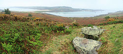
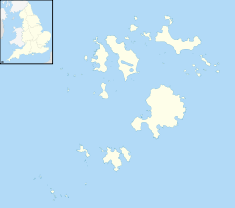
Obadiah's Barrow A view of Obadiah's BarrowLocation: Gugh, Cornwall, England[1] Coordinates: 49°53′44″N 6°20′05″W / 49.895594°N 6.334838°WCoordinates: 49°53′44″N 6°20′05″W / 49.895594°N 6.334838°W Area: Scilly Islands Built: During the Bronze Age Architectural style(s): British pre-Roman Architecture Scheduled monument Official name: Obadiah's Barrow Reference #: 303188[2] Obadiah's Barrow or Obadiah's Grave is one of around eighty burial chambers in the Scilly Islands, England.[3] It was excavated in 1901,[3] revealing a dozen cremation urns and a crouching skeleton.[4]
References
- ^ Ochyra, Helen (July 14, 2007). "Ten Tidal Islands". The Guardian. http://www.guardian.co.uk/travel/2007/jul/14/beach.uk21. Retrieved 4 December 2010.
- ^ "Detailed Result: Obadiah's Barrow". Pastscape. http://www.pastscape.org.uk/hob.aspx?hob_id=303188. Retrieved 30 November 2010.
- ^ a b Creigh, Andy. "Obadiah's Barrow". Megalithic Portal. http://www.megalithic.co.uk/article.php?sid=6333303. Retrieved 29 November 2010.
- ^ Dillon, Paddy (2006). Walking the Isles of Scilly. Cicerone Press. pp. 55. ISBN 1852844752. http://books.google.com/books?id=vP4Kew7CZbQC&pg=PA55&lpg=PA55&dq=Obadiah's+Barrow&source=bl&ots=H6OWYPIPol&sig=zmahpOZNUK-YBHn4fkBAx1RZwWk&hl=en&ei=x_TzTPfTLM3hnQeW77nYCg&sa=X&oi=book_result&ct=result&resnum=10&ved=0CEoQ6AEwCTgU#v=onepage.
External links
The Isles of Scilly Inhabited islands 
Uninhabited islands Annet · Bishop Rock · Crim Rocks · English Island · Great Ganilly · Gweal · Rosevear · Round Island · Samson · St Helens · Teän · Western Rocks · White Island · Zantman's RockTopics Environment · History · People · TransportCategories:- Isles of Scilly
- Archaeological sites in Cornwall
- Bronze Age Britain
- Barrows in the United Kingdom
- United Kingdom archaeology stubs
- Cornwall building and structure stubs
Wikimedia Foundation. 2010.


