Crim Rocks

Crim Rocks

Coordinates: 49°53′48″N 6°27′00″W / 49.8967°N 6.4500°W / 49.8967; -6.4500

Crim Rocks
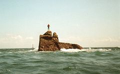
Peaked Rock - Isles of Scilly - geograph.org.uk - 971251.jpg
Peaked Rock, one of the Crim Rocks, and the most westerly piece of land of England
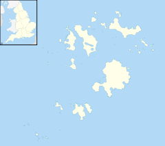
Crim Rocks is located in Isles of Scilly
{{{alt}}}
Crim Rocks

Red pog.svg Crim Rocks shown within Isles of Scilly
OS grid reference SV802092
List of places: UK • England • Isles of Scilly

Crim Rocks (Cornish: An Creeban) is a small group of uninhabited islands in the Isles of Scilly, England, United Kingdom.

They lie on the western fringe of the Isles of Scilly.[1] They are about 1.5 miles (2.4 km) north of Bishop Rock,[2] and about 0.25 miles (0.40 km) southwest of Zantman's Rock. The name may be cognate with the Middle Welsh "crimp" meaning "shin, ridge, or ledge."[1] The most conspicuous of the Crim Rocks is the Peaked Rock.[2]

See also

References

  1. ^ a b Andrew Breeze, (2007), Cornish toponyms: Crim Rocks, Darite, Perranuthnoe, Port Isaac, and Treverva. Celtica Vol. 25, page 2
  2. ^ a b Great Britain, Hydrographic Dept, (1891), Sailing directions for the west coast of England, page 26

External links


Wikimedia Foundation. 2010.

Игры ⚽ Нужна курсовая?

Look at other dictionaries:

  • Zantman's Rock — is located 34 miles to the west of Land s End, Cornwall, and six miles away from the Isles of Scilly. Viewed from a distance, it is barely visible on the surface of the waters. It is 2 miles north of Bishop s Rock Lighthouse. Between Zantman and… …   Wikipedia

  • Isles of Scilly — Scilly redirects here. For the area of Surrey, see Scilly Isles, Surrey. For the atoll in the Society Islands, sometimes called Scilly Atoll, see Manuae (Society Islands). Isles of Scilly Syllan Map of the Isles of Scilly …   Wikipedia

  • Extreme points of the United Kingdom — This is a list of the extreme points of the United Kingdom: the points that are farther north, south, east or west than any other location. Traditionally the extent of the island of Great Britain has stretched from Land s End to John o Groats… …   Wikipedia

  • 1983 British Airways Sikorsky S-61 crash — Accident summary Date 16 July 1983 Type Pilot error in poor visibility Site …   Wikipedia

  • Gugh — Coordinates: 49°53′47″N 6°19′58″W / 49.89626°N 6.33266°W / 49.89626; 06.33266 …   Wikipedia

  • Bishop Rock — Traduction à relire Bishop Rock → Bishop Rock …   Wikipédia en Français

  • Liste De Points Extrêmes Du Royaume-Uni — Voici une liste des points extrêmes du Royaume Uni. Cet article considère le Royaume Uni comme composé de l Angleterre, de l Écosse, du Pays de Galles (tous trois situés principalement sur l île de Grande Bretagne), de l Irlande du Nord (située… …   Wikipédia en Français

  • Liste de points extremes du Royaume-Uni — Liste de points extrêmes du Royaume Uni Voici une liste des points extrêmes du Royaume Uni. Cet article considère le Royaume Uni comme composé de l Angleterre, de l Écosse, du Pays de Galles (tous trois situés principalement sur l île de Grande… …   Wikipédia en Français

  • Liste de points extrêmes du Royaume-Uni — Carte du Royaume Uni Voici une liste des points extrêmes du Royaume Uni. Cet article considère le Royaume Uni comme composé de l Angleterre, de l Écosse, du Pays de Galles (tous trois situés principalement sur l île de Grande Bretagne), de l… …   Wikipédia en Français

  • Liste de points extrêmes du royaume-uni — Voici une liste des points extrêmes du Royaume Uni. Cet article considère le Royaume Uni comme composé de l Angleterre, de l Écosse, du Pays de Galles (tous trois situés principalement sur l île de Grande Bretagne), de l Irlande du Nord (située… …   Wikipédia en Français

Share the article and excerpts

Direct link
Do a right-click on the link above
and select “Copy Link”