- Nuyts Land District
-
Nuyts
Western Australia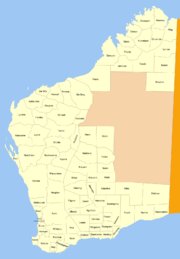
Lands administrative divisions around Nuyts Buningonia Giles Giles Balladonia Nuyts Nurina Mardarbilla Great Australian Bight Great Australian Bight
Nuyts Land District is a land district (cadastral division) of Western Australia, located within the Eastern and Eucla land divisions on the Nullarbor Plain. It spans roughly 31°00'S - 32°50'S in latitude and 124°00'E - 125°30'E in longitude.Location and features
The district is located on the Nullarbor Plain in the south-east of the state and falls generally between the Great Australian Bight to the south and the Trans-Australian Railway to the north. The Caiguna roadhouse on the Eyre Highway and the railway town of Rawlinna are located within its boundaries.[1]
History
The district was created on 4 March 1903, but only extended north to 31°30'S latitude.[2] When the Trans-Australian Railway was being built in 1914, the district was extended northwards and was defined in the Government Gazette:[3]
“ Bounded on the North by the centre of the Trans-Australian Railway Line; on the East by a North line from Point Dover; on the West by a North and South line through a point situate 20 miles East from the South-East corner of East Location 12, and on the South by the sea coast. ” References
- ^ "Index Map of Western Australia", Department of Lands and Surveys, 1949.
- ^ "New Land Districts (per 7835/97)". Western Australia Government Gazette: p. 1903:613. 4 March 1903.
- ^ "The Land Act, 1898. Amendment of Boundaries of Nurina, Mundrabilla and Nuyts Districts. (per 7835/97)". Western Australia Government Gazette: p. 1914:2559. 10 July 1914.
Coordinates: 31°35′S 124°40′E / 31.583°S 124.667°E
Land districts of Western Australia Ashburton · Avon · Balladonia · Balwina · Bulara · Bulga · Buningonia · Canning · Cockburn Sound · Dampier · De Grey · De Witt · Delisser · Dempster · Doongan · Dundas · Easton · Edel · Edjudina · Erivilla · Esperance · Fitzgerald · Fitzroy · Forrest · Fraser · Gascoyne · Giles · Gregory · Hampton · Hann · Hardey · Hay · Jarmura · Jaurdi · Jilbadji · Kaluwiri · Kent · King · Kojonup · Koondra · Kyarra · Leake · Luman · Lyndon · Lyons · Malcolm · Mardarbilla · Marmion · Marndoc · Meda · Melbourne · Milyuga · Mundrabilla · Murchison · Murray · Nabberu · Nelson · Neridup · Ngalbain · Ninghan · Nookawarra · Nuleri · Numalgun · Nurina · Nuyts · Oldfield · Omalinde · Pardu · Peawah · Plantagenet · Roe · Sussex · Swan · Teano · Thadoona · Tugaila · Ularring · Victoria · Wanman · Warramboo · Weld · Wellington · Wells · Williams · Windell · Yamarna · Yelina · Yilgarn · Yowalga · Yurabi
Categories:- Land districts of Western Australia
- Goldfields-Esperance
- Western Australia geography stubs

Wikimedia Foundation. 2010.