- De Grey Land District
-
De Grey
Western Australia
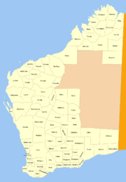
Region: Pilbara Lands administrative divisions around De Grey Indian Ocean Pardu Pardu Forrest De Grey Windell Koondra De Grey Land District is a land district (cadastral division) of Western Australia and a subdivision of the North-West Land Division. It includes the Pilbara towns of Marble Bar and Nullagine and the former town of Goldsworthy.
Coordinates: 21°20′S 120°05′E / 21.333°S 120.083°ELand districts of Western Australia Ashburton · Avon · Balladonia · Balwina · Bulara · Bulga · Buningonia · Canning · Cockburn Sound · Dampier · De Grey · De Witt · Delisser · Dempster · Doongan · Dundas · Easton · Edel · Edjudina · Erivilla · Esperance · Fitzgerald · Fitzroy · Forrest · Fraser · Gascoyne · Giles · Gregory · Hampton · Hann · Hardey · Hay · Jarmura · Jaurdi · Jilbadji · Kaluwiri · Kent · King · Kojonup · Koondra · Kyarra · Leake · Luman · Lyndon · Lyons · Malcolm · Mardarbilla · Marmion · Marndoc · Meda · Melbourne · Milyuga · Mundrabilla · Murchison · Murray · Nabberu · Nelson · Neridup · Ngalbain · Ninghan · Nookawarra · Nuleri · Numalgun · Nurina · Nuyts · Oldfield · Omalinde · Pardu · Peawah · Plantagenet · Roe · Sussex · Swan · Teano · Thadoona · Tugaila · Ularring · Victoria · Wanman · Warramboo · Weld · Wellington · Wells · Williams · Windell · Yamarna · Yelina · Yilgarn · Yowalga · Yurabi
Categories:- Land districts of Western Australia
- Western Australia geography stubs
Wikimedia Foundation. 2010.
