- Numbered Streets of St. Louis, Missouri
-
Number streets of St. Louis, Missouri, start at the Mississippi River and increase as they go west. They are primarily found Downtown and in Downtown West.
1st Street
1st Street is broken by the grounds of the Jefferson National Expansion Memorial, location of the Gateway Arch. South of the Memorial, it runs from Poplar Street down through the Kosiusko neighborhood to Victor Street where it dead-ends. 1st Street starts up again on Potomac Street and eventually turns into Gasconade Street. To the north, it runs from Washington Avenue as far as North Market Street (different from the downtown Market Street. 1st Street briefly shows up again in Near North Riverfront before turning into Kissock Avenue.
2nd Street
3rd Street
In the 1930s, the part of 3rd street beside the Jefferson National Expansion Memorial was converted into Memorial Drive. North of Biddle Street, 3rd merges with Broadway and continues on to the city limits.
4th Street
5th Street
5th Street is officially known as Broadway. Broadway goes as far south as Lemay in St. Louis County where it turns into Kingston Drive. To the north, Broadway intersects with 3rd Street and runs with it as far as Riverview Blvd where it then becomes Bellefontaine road. Broadway is one of the major boulevards for St. Louis. In the north it passes O'Fallon Park and Bellefontaine and Calvary Cemeteries.
6th Street
Northbound street
7th Street
8th Street
9th Street
10th Street
11th Street
12th Street
12th Street is officially known as Tucker Boulevard. It is double sized and serves as the border between Downtown and Downtown West.
13th Street
14th Street
15th Street
16th Street
17th Street
17th Street is notorious for the 7-11 that operates by Plaza Square Apartments. As the only convenience store in the area it receives a large amount of foot traffic and a fair amount of petty crime.
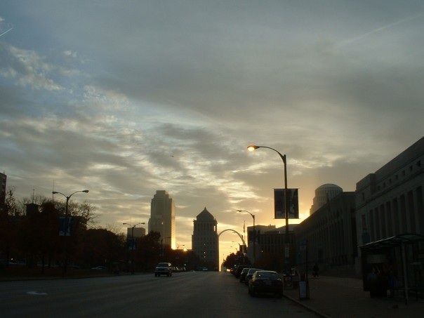
-
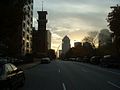
at dawn at 17th and Chestnut
18th Street
 18th Street in Downtown St. Louis
18th Street in St. Louis, Missouri runs north-south through Downtown West. Truman Parkway becomes 18th at Chouteau Avenue and continues north over the Union MetroLink Station. It passes between the St. Louis Post Office and Union Station on to the Gateway Mall where it separates the Mall's Neighborhood Room from Aloe Plaza. It continues north past the Salvation Army's Railton Building. 18th Street ends in Carr Square where it comes to a T on O'Fallon Street.
-
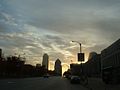
at dawn at 18th and Market
19th Street
20th Street
21st Street
22nd Street
As part of Paul McKee's NorthSide project, the broken section of 22nd street near the I-64 interchange is to be restored and rebuilt. A large office tower has been proposed to anchor it to the expanded Gateway Mall.
23rd Street
23rd is an irregular street that is broken up in many places. One such break was created by the Pruitt–Igoe site.
24th Street
24th Street has disappeared over time.
25th Street
25th Street appears to the north of downtown where Jefferson Avenue curves and creates space for another road.
See also
Streets of St. Louis, Missouri
References
- Charles C. Savage (1987), Architecture of the private streets of St. Louis
- A walk in the streets of St. Louis in 1845, 1928
- A. N. Milner (1898), General information: city streets St. Louis
- Cory Allan Davis (2005), On these very streets: the automobile and the urban environment in St. Louis 1920-1930, University of Missouri-Columbia
- Norman J. Johnston (1962), St. Louis and her private residential streets
- Street Lighting in St. Louis, Civic League Of Saint Louis, 1908
- Earl B. Morgan (1908), Street pavements in St. Louis
- William B. Magnan (1994), Streets of St. Louis: An Entertaining History of St. Louis Street Names
- Andrew D. Young, Ray Gehl, Mark D. Goldfeder (2002), Streets & streetcars of St. Louis: a sentimental journey
- Andrew Hurley (1999), Streets and neighborhood history: a handbook for researchers in St. Louis, St. Louis. Public Policy Research Centers
- Virginia Nester (1991), Streets of St. Louis, Mo: avenues through time
- Oscar Newman, Frank J. Wayno (1974), The privatization of streets in St. Louis: its effect on crime and community stability, National Science Foundation (U.S.)
- William H. Bryan (1894), The street railways of St. Louis
- McCune Gill (1920), The streets of St. Louis
External links
Streets and highways of St. Louis Numbered Streets 1st St. • 2nd St. • 3rd St. • 4th St. • 5th St. • 6th St. • 7th St. • 8th St. • 9th St. • 10th St. • 11th St. • 12th St. • 13th St. • 14th St. • 15th St. • 16th St. • 17th St. • 18th St. • 19th St. • 20th St. • 21st St. • 22nd St. • 23rd St. • 24th St. • 25th St.Streets Arsenal St. • Bates St. • Biddle St. • Carr St. • Chestnut St. • Chippewa St. • Cole St. • Commercial St. • Delor St. • Germania St. • Hall St. • Itaska Street • Keokuk St. • La Salle St. • Locust St. • Market St. • Meramec St. • Miami St. • O'Fallon St. • Olive St. • Palm St. • Papin St. • Parnell St. • Pine St. • Salisbury St. • Sarah St. • Sidney St. • St. Charles St. • Thomas St. • Utah St. • Walnut St. • Wyoming St.Boulevards Leonor K. Sullivan Blvd. • Lacledes Landing Blvd. • Tucker Blvd. • Grand Blvd. • Kingshighway Bivd. • Delmar Blvd. • Lindell Blvd. • Page Blvd. • Lindbergh Blvd. • Union Blvd. • Skinker Blvd. • Brentwood Blvd. • Olive Blvd. • Midland Blvd. • Big Bend Blvd. • Goodfellow Blvd. • James S. McDonnell Blvd. • Lewis & Clark Blvd. • Holly Hills Blvd. • Wydown Blvd. • Forsyth Blvd. • Carondelet Blvd. • Christy Blvd. • W. Pine Blvd. • Shaw Blvd.Avenues Jefferson Ave. • St. Louis Ave. • W. Florissant Ave. • Manchester Ave. • Chouteau Ave. • Lucas Ave. • Clark Ave. • Hampton Ave. • Page Ave. • Vandeventer Ave. • Maryland Ave. • Compton Ave. • Euclid Ave. • Meramec Ave. • Cass Ave. • Newstead Ave. • DeBaliviere Ave. • Taylor Ave. • Park Ave. • Lafayette Ave. • Magnolia Ave. • Loughborough Ave. • Adelaide Ave. • Tower Grove Ave. • Frost Ave. • Dale Ave. • Southwest Ave. • Oakville Ave. • Kingsland Ave. • Clayton Ave. • Oakland Ave. • Laclede Ave. • Brannon Ave. • Jamieson Ave. • Nebraska Ave.Roads Natural Bridge Rd. • St. Charles Rock Rd. • Gravois Rd. • Missouri Bottom Road • Ladue Rd. • Clayton Rd. • Hanley Rd. • North & South Rd. • Lucas & Hunt Rd. • Jennings Station Rd. • New Ballas Rd. • Spoede Rd. • Halls Ferry Road • Old Halls Ferry Rd. • New Halls Ferry Rd. • Fee Fee Rd. • Airport Rd. • Old Bonhomme Rd. • Florissant Rd. • Big Bend Rd. • State Rd. • Morganford Rd. • Watson Rd. • MacKenzie Rd. • Tesson Ferry Rd. • Dunn Road • Chambers Rd. • Meramec Bottom Rd. • Brown Rd.Parkways, Drives, and Expressways Memorial Dr. • Delmar Loop • Forest Park Pkwy. • River Des Peres Pkwy • Dr. Martin Luther King Dr. • Riverview Dr. • Maryland Heights Expy • Earth City Expy • Truman Pkwy. • Chesterfield Pkwy. • Bermuda Dr.See also Streets and Highways of St. Louis, MissouriCategories:- Streets in St. Louis, Missouri
-

Wikimedia Foundation. 2010.