- Ñuflo de Chávez Province
-
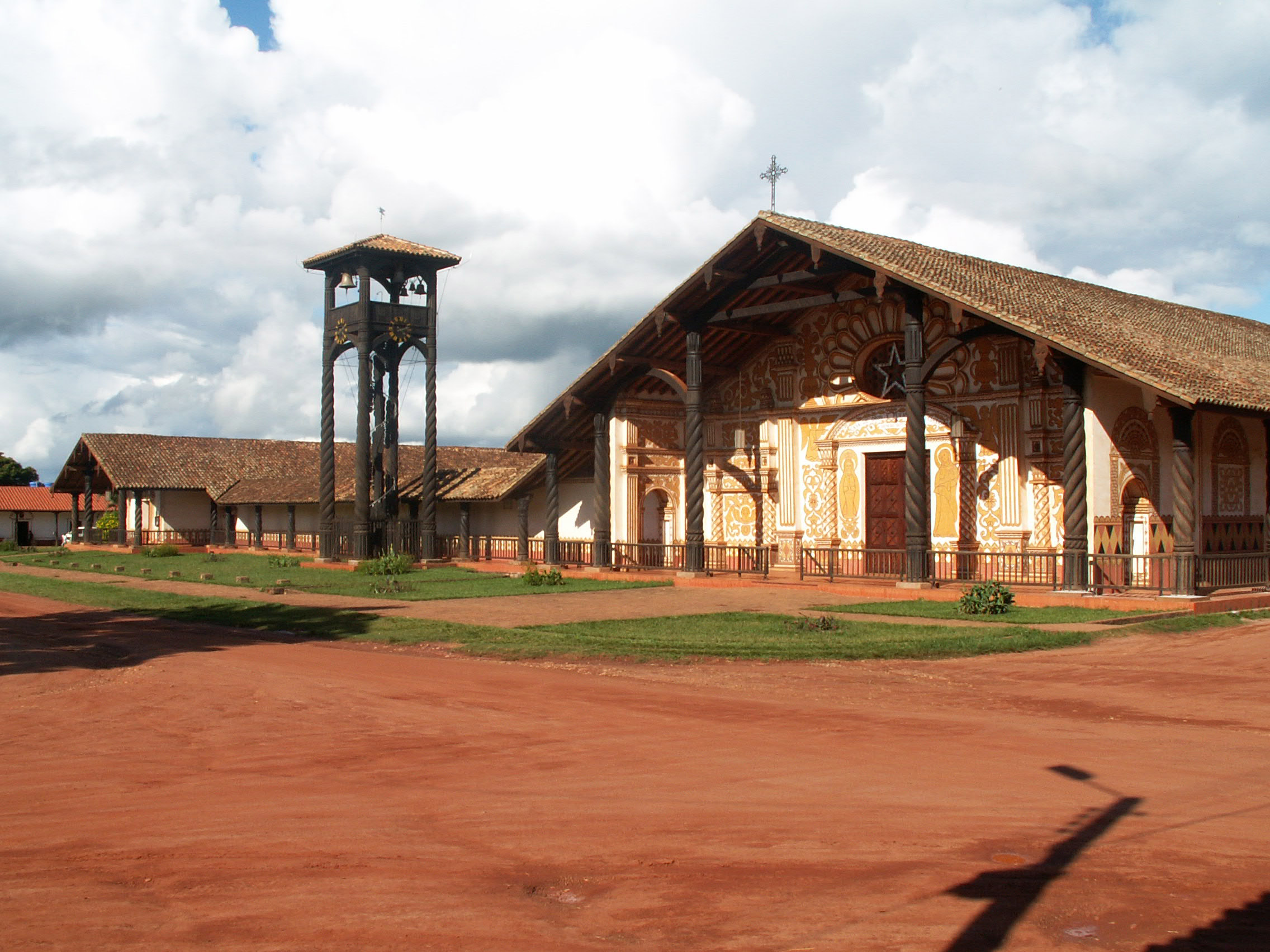
Ñuflo de Chávez Province — Province — Mission church in Concepción known as part of the Jesuit Missions of the Chiquitos and declared a World Heritage Site in 1990 Location of Ñuflo de Chávez Province within Bolivia
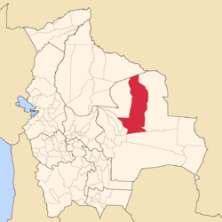 Provinces of the Santa Cruz Department
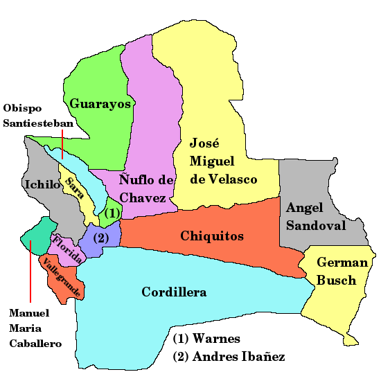
Coordinates: 16°00′0″S 62°00′0″W / 16°S 62°W Country  Bolivia
Department Santa Cruz Department Capital Concepción Government – Sub governor Widen Barbery (Concepción) Area – Total 20,907.4 sq mi (54,150 km2) Elevation 1,627 ft (496 m) Population (2001) – Total 93,997 – Density 4.4/sq mi (1.7/km2) – Ethnicities Chiquitos Time zone BOT (UTC-4) Area code(s) BO.SC.NC Ñuflo de Chávez[1] is one of the fifteen provinces of the Bolivian Santa Cruz Department and is situated in the northern central parts of the department. The name of the province honors the conquistador Ñuflo de Chaves (1518–1556) who founded the city of Santa Cruz de la Sierra. Its capital is Concepción. The province was created by law of September 16, 1915, during the presidency of Ismael Montes. Originally it was part of the Chiquitos Province.[2]
Contents
Location
Ñuflo de Chávez Province is located between 13° 45' and 17° 30' South and between 61° 30' and 63° 25' West. It extends over a length of 520 km from north to south, and up to 250 km from west to east.
The province is situated in the Bolivian lowlands and borders Beni Department in the north, Guarayos Province in the north-west, Obispo Santistevan Province and Ignacio Warnes Province in the south-west, Andrés Ibáñez Province and Chiquitos Province in the south, and José Miguel de Velasco Province in the east.
Division
The province comprises six municipalities which are further subdivided into cantons:[2]
Section Municipality Inhabitants (2001) [3] Seat Inhabitants (2001) 1st Concepción Municipality 14,522 Concepción 5,586 2nd San Javier Municipality (also San Xavier Municipality) 11,316 San Javier 5,538 3rd San Ramón Municipality 5,660 San Ramón 4,746 4th San Julián Municipality 56,206 San Julián 6,585 5th San Antonio de Lomerío Municipality 6,293 San Antonio de Lomerío 1,313 6th Cuatro Cañadas Municipality 17, 574 Cuatro Cañadas 4,571 Population
The inhabitants of the Ñuflo de Chávez Province are mainly Chiquitos whose culture roots in the fusion of their ancient customs and the influence of the Jesuit missionaries.[2] During the 2001 census the ethnic composition of the population was as follows:[4]
Ethnic group Concepción Municipality (%) San Javier Municipality (%) San Ramón Municipality (%) San Julián Municipality (%) San Antonio de Lomerío Municipality (%) Cuatro Cañadas Municipality (%) Quechua 4.2 3.6 13.5 49.6 1.5 36.4 Aymara 1.2 1.4 2.3 2.2 0.2 2.2 Guaraní, Chiquitos or Moxos 67.8 68.4 31.1 8.6 87.0 7.8 Not indigenous 25.1 24.7 52.5 38.1 10.7 51.3 Other indigenous groups 1.8 1.9 0.7 1.5 0.7 2.4 The population of the province has increased by more than 100 % over the recent two decades:
- 1992: 61,008 inhabitants (census)
- 2001: 93,997 inhabitants (census)
- 2005: 111,813 inhabitants (est.)[5]
- 2010: 131,856 inhabitants (est.)[6]
48.3 % of the population are younger than 15 years old. (1992)
The literacy rate of the province is 72.6 %.
87.3 % of the population have no access to electricity, 50.4 % have no sanitary facilities. (1992)
79.5 % of the population are Catholics, 17.2 % are Protestants. (1992)
In 1992 91.6 % of the population spoke Spanish, 30.1 % Quechua, 2.0 % Aymara and 1.2 spoke Guaraní. During the 2001 census Spanish was spoken by 79,377 people, Quechua by 20,763, Aymara by 1,362, Guarani by 1,002, other native languages by 3,619 and foreign languages by 5,617 people. The following table shows the number of speakers per municipality:[4]
Language Concepción Municipality (%) San Javier Municipality (%) San Ramón Municipality (%) San Julián Municipality (%) San Antonio de Lomerío Municipality (%) Cuatro Cañadas Municipality (%) Quechua 363 247 468 14,855 46 4,782 Aymara simi 120 104 75 804 7 252 Guaraní 53 142 25 682 14 86 Another native 901 128 29 138 2.221 202 Spanish 13,370 10,414 5,278 32,182 5.480 12.637 Foreign 134 102 84 1,209 199 3,864 Only native 138 31 46 2,430 162 628 Native and Spanish 1,264 559 522 13,469 2,118 4,558 Only Spanish 12,119 9,865 4,769 19,405 3,474 11,018 Economy
The principal economic activities are devoted to animal husbandry, dairy farming, forestry and tourism. Another important occupation is handicraft like the fabrication of hammocks, textiles, hats, bags and baskets.[2]
See also
- Jesuit Missions of the Chiquitos
References
- ^ Ñuflo de Chaves (1518-1568) was a Spanish conquistador. He is best known for founding the city of Santa Cruz de la Sierra.
- ^ a b c d Official site of Ñuflo de Chávez Province (Spanish)
- ^ Instituto Nacional de Estadística, Bolivia (Spanish)
- ^ a b obd.descentralizacion.gov.bo / Observatorio Bolivia Democrático (inactive site)
- ^ Instituto Nacional de Estadística
- ^ Instituto Nacional de Estadística - Proyecciones
External links
Santa Cruz Department Andrés Ibáñez · Ángel Sandoval · Chiquitos · Cordillera · Florida · Germán Busch · Guarayos · Ichilo · Ignacio Warnes · José Miguel de Velasco · Manuel María Caballero · Ñuflo de Chávez · Obispo Santistevan · Sara · Vallegrande
Categories:

Wikimedia Foundation. 2010.