- North Platte Project
-
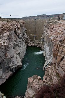 Pathfinder Dam
The North Platte Project (originally the Sweetwater Project) is an irrigation project in the U.S. states of Wyoming and Nebraska. The project provides irrigation service to about 335,000 acres (1,360 km2). The primary water storage for the project is in Pathfinder Reservoir in Wyoming. Downstream, Guernsey Dam manages river flow and provides secondary storage for water released from Pathfinder. Near Fort Laramie the Whalen Diversion Dam diverts water into Fort Laramie Canal and Interstate Canal which distribute water to farms in Wyoming and Nebraska.
History
Surveys for the project began shortly after the Reclamation Act was enacted in 1902. The project was approved by the Department of the Interior in 1903, and work began on Pathfinder Dam and Interstate Canal in 1905. Guernsey Dam was completed in 1927.
Facilities
- Pathfinder Dam
- Guernsey Dam and Guernsey Powerplant
- Whalen Diversion Dam
- Interstate Canal
- Fort Laramie Canal
References
Categories:- Buildings and structures in Wyoming
- Buildings and structures in Nebraska
- Water management authorities in the United States

Wikimedia Foundation. 2010.