- Nordaust-Svalbard Nature Reserve
-
Nordaust-Svalbard Nature Reserve 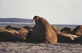
Walrus colony on Nordaustlandet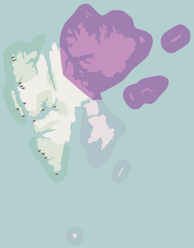
Location Svalbard, Norway Nearest city Longyearbyen Coordinates 79°N 23°E / 79°N 23°ECoordinates: 79°N 23°E / 79°N 23°E Area 55,354 km2 (21,372 sq mi), of which
18,663 km2 (7,206 sq mi) is land
36,691 km2 (14,166 sq mi) is waterEstablished 1 July 1973 Governing body Norwegian Directorate for Nature Management Nordaust-Svalbard Nature Reserve (Norwegian: Nordaust-Svalbard naturreservat) is located in the north-eastern part of the Svalbard archipelago in Norway. The nature reserve covers all of Nordaustlandet, Kong Karls Land, Kvitøya, Sjuøyane, Storøya, Lågøya, Wilhelmøya, Wahlbergøya and a small section of the north-east corner of Spitsbergen. The reserve is 55,354 square kilometres (21,372 sq mi), of which 18,663 square kilometres (7,206 sq mi) is on land and 36,691 square kilometres (14,166 sq mi) is on water—making it the largest preserved area in Norway (including national parks). It includes the largest glacier in Norway, Austfonna, as well as and Vestfonna and parts of Olav V Land. The reserve has been protected since 1 July 1973 and borders in the south to Søraust-Svalbard Nature Reserve.[1]
The Kong Karls Land archipelago serves as the most important breeding ground for polar bears in Svalbard and Franz Josef Land; therefore, the archipelago is completely off limit to all visitors. Walruses have resting places in the reserve. At Alkefjleet, guillemots have a nesting ground, and also brent geese can be found breeding in the reserve, as can Sabine's gull and ivory gull. Other important breeding areas for seabirds include Sjuøyane, Lågøya and Hinlopenstretet.[1] Common animals within the nature reserve is Arctic fox and Svalbard reindeer.[2]
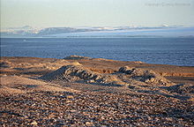
Three-quarters of Nordaustlandet is covered by glaciers, the largest being Austfonna at 7,000 square kilometres (2,700 sq mi). The landscape has low, rounded hills and plains, created by glaciation during former ice ages. Most of the reserve has little or no vegetation, and the reserve belongs to the polar desert. The nature reserve is used by scientists and tourists, the latter commonly sailing eastwards along Hinlopenstretet or round Nordaustlandet. The most popular places to visit are Sjuøyane, Alkefjellet, Bråsvellbreen and Kvitøya.[1]
There are some cultural heritage sites within the reserve, including a Russian Orthodox cross on Krossøya, and Andréeneset on Kvitøya, the starting point for the S. A. Andrée's Arctic balloon expedition of 1897. There is also a winter camp at the shores of Sorgfjorden, which hosted a 1899–1900 Swedish-Russian Arc-of-Meridian Expedition to measure the meridian arc. In Rijpfjorden there is a German meteorological station from World War II.[1]
References
- ^ a b c d "Protected Areas in Svalbard" (in Norwegian). Norwegian Directorate for Nature Management. http://www.dirnat.no/attachment.ap?id=1043. Retrieved 28 March 2010.
- ^ "Protected areas". Governor of Svalbard. http://www.sysselmannen.no/hovedEnkel.aspx?m=45281. Retrieved 27 March 2010.
Categories:- IUCN Category Ia
- Nature reserves in Svalbard
- Protected areas established in 1973
- 1973 establishments in Norway


Wikimedia Foundation. 2010.