- Needle Peak (Livingston Island)
-
Needle Peak 
Needle Peak from Bransfield Strait, 2004Elevation 370 m (1,214 ft) [1] Location Location Livingston Island, Antarctica Coordinates 62°44′S 60°11′W / 62.733°S 60.183°WCoordinates: 62°44′S 60°11′W / 62.733°S 60.183°W[1] 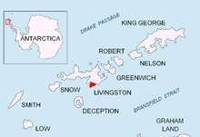 Location of Rozhen Peninsula on Livingston Island in the South Shetland Islands.
Needle Peak is a sharply-pointed black peak, 370 m, standing at the west side of Brunow Bay on the south coast of Livingston Island in the South Shetland Islands. Situated in the southeast foothills of Friesland Ridge on Rozhen Peninsula, 1 km south-southeast of Ludogorie Peak, and surmounting Prespa Glacier to the west, Samuel Point to the east by south, and Brunow Bay to the northeast.
The feature was named ‘Barnards Peak’ on James Weddell's chart published in 1825, but the name ‘Needle Peak’ given by Discovery Investigations personnel following a 1935 survey has succeeded it in usage. The name Barnard Point has been approved for the nearby point at the southeast side of False Bay.[1]
Maps
- L.L. Ivanov et al., Antarctica: Livingston Island and Greenwich Island, South Shetland Islands (from English Strait to Morton Strait, with illustrations and ice-cover distribution), 1:100000 scale topographic map, Antarctic Place-names Commission of Bulgaria, Sofia, 2005
- L.L. Ivanov. Antarctica: Livingston Island and Greenwich, Robert, Snow and Smith Islands. Scale 1:120000 topographic map. Troyan: Manfred Wörner Foundation, 2009. ISBN 978-954-92032-6-4
Reference

This Livingston Island location article is a stub. You can help Wikipedia by expanding it.

