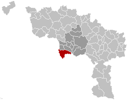
- Honnelles
-
Honnelles 
Flag
Coat of armsLocation in Belgium Coordinates: 50°21′N 03°43′E / 50.35°N 3.717°E Country Belgium Region Wallonia Community French Community Province Hainaut Arrondissement Mons Government – Mayor Bernard Paget (PS) – Governing party/ies PS Area – Total 43.65 km2 (16.9 sq mi) Population (1 January 2010)[1] – Total 4,971 – Density 113.9/km2 (295/sq mi) Postal codes 7387 Area codes 065 Website www.honnelles.be Honnelles is a Walloon municipality located in the Belgian province of Hainaut. On January 1, 2006 Honnelles had a total population of 4,998. The total area is 43.65 km² which gives a population density of 114 inhabitants per km².
Honnelles is located 18 km southwest of Mons, 16 km east of the French city Valenciennes, 50 km west of Charleroi and 72 km southwest of Brussels.
The municipality includes the localities of Angre, Angreau, Athis, Autreppe, Erquennes, Fayt-le-Franc, Marchipont, Montignies-sur-Roc, Onnezies and Roisin.
References
- ^ Population per municipality on 1 January 2010 (XLS; 221 KB)
Ath 
Charleroi Mons Mouscron Soignies Thuin Anderlues · Beaumont · Binche · Chimay · Erquelinnes · Estinnes · Froidchapelle · Ham-sur-Heure-Nalinnes · Lobbes · Merbes-le-Château · Momignies · Morlanwelz · Sivry-Rance · ThuinTournai Antoing · Brunehaut · Celles · Estaimpuis · Leuze-en-Hainaut · Mont-de-l'Enclus · Pecq · Péruwelz · Rumes · TournaiCategories:- Municipalities of Hainaut
- Hainaut geography stubs
Wikimedia Foundation. 2010.


