- Colfontaine
-
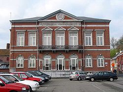
Colfontaine Colfontaine: the Town Hall 
Flag
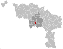
Coat of armsLocation in Belgium Coordinates: 50°23′N 03°52′E / 50.383°N 3.867°E Country Belgium Region Walloon Region Community French Community Province Hainaut Arrondissement Mons Government - Mayor Luciano D'Antonio - Governing party/ies PS Area - Total 13.62 km2 (5.3 sq mi) Population (1 January 2010)[1] - Total 20,090 - Density 1,475/km2 (3,820.3/sq mi) Postal codes 7340 Area codes 065 Website www.colfontaine.be Colfontaine is a Walloon municipality located in the Belgian province of Hainaut, and comprises the former villages of Pâturages, Warquignies, Wasmes, and Petit Wasmes.
On 1 January 2006 the municipality had 20,021 inhabitants. The total area is 13.62 km², giving a population density of 1,470 inhabitants per km².
References
- ^ Population per municipality on 1 January 2010 (XLS; 221 KB)
External links
- Official website of the commune of Colfontaine (in French)
- Independent Colfontaine website (in French)
Ath 
Charleroi Mons Mouscron Soignies Thuin Anderlues · Beaumont · Binche · Chimay · Erquelinnes · Estinnes · Froidchapelle · Ham-sur-Heure-Nalinnes · Lobbes · Merbes-le-Château · Momignies · Morlanwelz · Sivry-Rance · ThuinTournai Antoing · Brunehaut · Celles · Estaimpuis · Leuze-en-Hainaut · Mont-de-l'Enclus · Pecq · Péruwelz · Rumes · TournaiCategories:- Municipalities of Hainaut
- Hainaut geography stubs
Wikimedia Foundation. 2010.


