- Tell Brak
-
Tell Brak
Nagar (ancient name)
 Shown within Syria
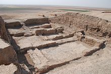
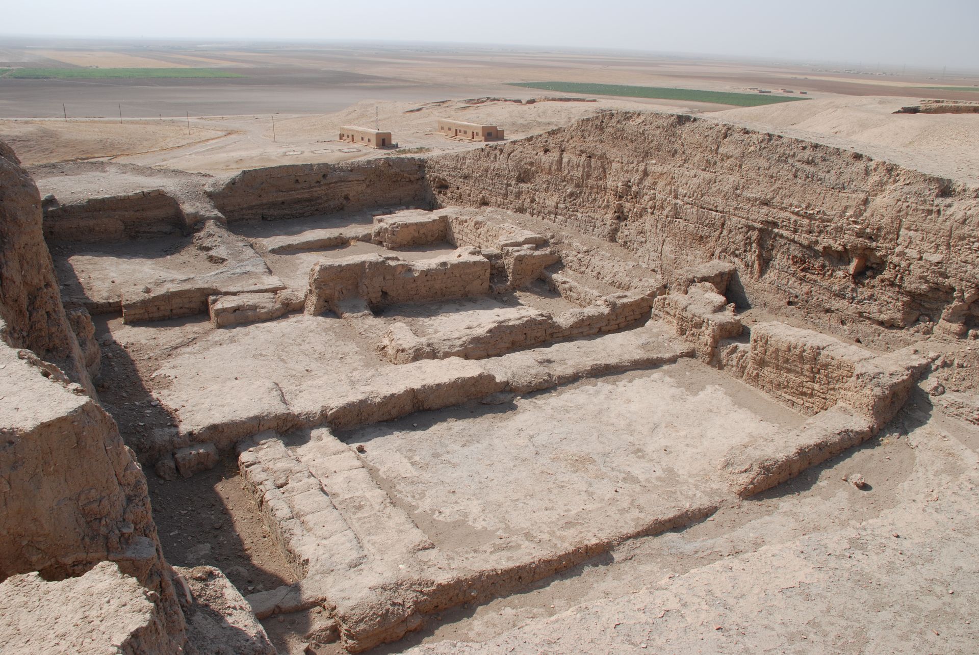
Location Syria Region Al-Hasakah Governorate Coordinates 36°40′02″N 41°03′30″E / 36.667222°N 41.058333°E Type tell Area 130 hectares (320 acres) Height 40 metres (130 ft) History Periods Halaf, Ubaid, Uruk, Early Bronze Age, Middle Bronze Age, Late Bronze Age Site notes Excavation dates 1937–1938, 1976–2011 Archaeologists M.E.L. Mallowan, D. Oates, J. Oates Public access yes Website mcdonald.cam.ac.uk/projects/brak Tell Brak, ancient Nagar, is a tell, or settlement mound, in the Upper Khabur area in Al-Hasakah Governorate, northeastern Syria. The site was occupied between the sixth and second millennia BCE. At 40 metres (130 ft) in height, and an area of approximately 130 hectares (320 acres), it is one of the largest archaeological sites in northern Mesopotamia.
Contents
History of research
Tell Brak was excavated by the British archaeologist Sir Max Mallowan in 1937 and 1938.[1] A team from the Institute of Archaeology of the University of London and later from the McDonald Institute for Archaeological Research of the University of Cambridge led by David and Joan Oates worked there for 14 seasons between 1976 and 1993.[2][3][4] Following the Oates' team, the field director of the dig was Roger Matthews. In 1998, Geoff Emberling, who had dug with the Matthews team became co-field director (1998–2004) with Helen McDonald, the longtime registrar and draftsperson at Brak.[5][6] [7] This effort was co-sponsored by the British Institute for the Study of Iraq and the Metropolitan Museum of Art. Augusta McMahon, of the University of Cambridge, took over as field director in the spring of 2006. [8] A regional archaeological field survey in a 20 km (12 mi) radius around Brak was supervised by Henry T. Wright of the University of Michigan (2002–2005). The finds from the excavations at Tell Brak are on display in the Deir ez-Zor Museum.[9]
Occupation history
Halaf period
A small settlement existed at the site as early as 6000 BCE, and materials from the Late Neolithic Halaf culture have been found there.[10]
Late Chalcolithic period
Occupation continued into the succeeding Ubaid and Uruk periods. Excavations and surface survey of the site and its surroundings reveal a city that developed from the early 4th millennium BCE (Late Chalcolithic 3 Period) contemporaneously with (or even slightly earlier than) better known cities of southern Mesopotamia, such as Uruk. Public buildings include the Eye Temple at the settlement's southern edge and an administrative building with attached workshops and kilns at its northern edge (Area TW). From ca 3500 BCE, Brak, along with many other settlements in northern Mesopotamia, was partly colonised by immigrants from Late Uruk southern Mesopotamia. Among extensive Late Uruk materials found at Brak/Nagar is a standard text for educated scribes (the "Standard Professions" text, known from Uruk IV), part of the standardized education taught in the 3rd millennium BCE over a wide area of Syria and Mesopotamia.[11]
The most famous of the Late Chalcolithic features is the 4th millennium BCE "Eye Temple", which was excavated in 1937–38. The temple, built around 3500–3300 BCE, was named for the hundreds of small alabaster "eye idol" figurines, which were incorporated into the mortar with which the mudbrick temple was constructed. The building's surfaces were richly decorated with clay cones, copper panels and gold work, in a style comparable to contemporary temples of Sumer. The most dramatic discoveries during recent excavations are a series of mass graves dating to circa 3800–3600 BCE, which suggest that the process of urbanization was accompanied by an increase in the organization of warfare.
Early Bronze Age
Third millennium BCE cuneiform texts from the city of Ebla and from Brak itself identify Nagar (Brak's ancient name) as the major point of contact between the cities of the northern Levant, eastern Anatolia and northern Mesopotamia. Nagar's active commercial and cultural interchanges with Ebla are also recorded, as its power over the intervening city of Nabada (Tell Beydar). A partially-burned administrative building or temple near the centre of Brak, destroyed around 2400 BCE (rediscovered in 1998) has a curved exterior wall reminiscent of the Khafajah Temple Oval in central Mesopotamia. Skeletal remains show that the city was a source for donkey-onager hybrids used for drawing wheeled carts before the introduction of the horse, about 2300 BCE.[12][13][14] In the late 3rd millennium BCE, Nagar lay at the northern edge of the Akkadian sphere of influence. To the north, the nearby city of Urkesh may have retained some form of independence. The palace-stronghold of Naram-Sin of the 22nd century BCE, built at a time when Nagar was a northern administrative center of the Akkadian Empire, was more of a depot for the storage of collected tribute and agricultural produce than a residential seat. The excavators do not credit the Akkadians with political control of the city, and the political significance of cuneiform administrative documents in Akkadian retrieved from the palace are open to interpretation.[15] At the end of the Early Bronze Age, the site shrank in size, contemporary with a region-wide settlement disruption that some scholars have attributed to dramatic climate change.
Middle Bronze Age
In its early 2nd millennium BCE strata (contemporary with the Old Babylonian Period and the local kingdom of Shamshi-Adad), the site remains relatively small, with at least two areas of houses restricted to the highest ridge of the mound.
Late Bronze Age
In the latter half of the 2nd millennium BCE, the still relatively small area occupied contained a Late Bronze Age monumental palace and Mitanni temple (circa 1500-1360 BCE) and a continuation of the sequence of domestic occupation. A "suburb" off the main mound to the north may have comprised additional houses but is now all-but-destroyed through modern agriculture.
See also
Notes
- ^ Mallowan, M.E.L. (1947). "Excavations at Brak and Chagar Bazar". Iraq 9: 1–259. ISSN 0021-0889. http://www.jstor.org/stable/i389659.
- ^ Oates, David; Oates, Joan (1991). "Excavations at Tell Brak, 1990–91". Iraq 53: 127–145. ISSN 0021-0889. JSTOR 4200342.
- ^ Oates, David; Oates, Joan; McDonald, Helen (1998). Excavations at Tell Brak - Vol. 1: The Mitanni and Old Babylonian periods. London: British School of Archaeology in Iraq. ISBN 0951942050.
- ^ Oates, David; Oates, Joan; McDonald, Helen (2002). Excavations at Tell Brak - Vol. 2: Nagar in the Third Millennium BC. London: British School of Archaeology in Iraq. ISBN 0951942093.
- ^ Geoff Emberling et. al., Excavations at Tell Brak 1998: Preliminary Report, Iraq, vol. 61, pp. 1-41, 1999
- ^ Emberling, Geoff; McDonald, Helen (2001). "Excavations at Tell Brak 2000: Preliminary Report". Iraq 63: 21–54. ISSN 0021-0889. JSTOR 4200500.
- ^ G. Emberling and H. McDonald, Excavations at Tell Brak 2001-2002: Preliminary report, Iraq, vol. 65, pp. 1-76, 2003
- ^ A. McMahon et al., Excavations at Tell Brak 2006-2007, Iraq, vol. 69, pp. 145-171, 2007
- ^ Bonatz, Dominik; Kühne, Hartmut; Mahmoud, As'ad (1998). Rivers and steppes. Cultural heritage and environment of the Syrian Jezireh. Catalogue to the Museum of Deir ez-Zor. Damascus: Ministry of Culture. OCLC 638775287.
- ^ Oates, Joan; Oates, David (1994). "Tell Brak: A Stratigraphic Summary, 1976-1993". Iraq 56: 167–176. ISSN 0021-0889. JSTOR 4200394.
- ^ Oates, Joan (1987). "A Note on 'Ubaid and Mitanni Pottery from Tell Brak". Iraq 49: 193–198. ISSN 0021-0889. JSTOR 4200272.
- ^ Juliet Clutton-Brock, A Dog and a Donkey Excavated at Tell Brak, Iraq, vol. 51, pp. 217-224, 1989
- ^ Juliet Clutton-Brock and Sophie Davies, More Donkeys from Tell Brak, Iraq vol. 55, pp. 209-221, 1993
- ^ "Archaeology in Mesopotamia: Digging deeper et Tell Brak". British Academy. http://www.britac.ac.uk/events/2004/reckitt.html. Retrieved 3 December 2010.
- ^ Milano, Lucio (1991). Mozan 2. The Epigraphic Finds of the Sixth Season. Malibu: Udena. ISBN 0890032769. http://128.97.6.202/urkeshpublic/921-02.htm.
Further reading
- Matthews, Donald M. (1997). The early glyptic of Tell Brak: cylinder seals of third millennium Syria. Göttingen: Vandenhoeck & Ruprecht. ISBN 3525538960.
- Matthews, Donald; Eidem, Jesper (1993). "Tell Brak and Nagar". Iraq 55: 201–207. ISSN 0021-0889. JSTOR 4200376.
- Matthews, Roger (2001). Excavations at Tell Brak - Vol. 4: Exploring an Upper Mesopotamian Regional Centre, 1994–1996. Cambridge: McDonald Institute for Archaeological Research. ISBN 1902937163.
- J. Oates, Digging Deeper at Tell Brak, Proceedings of the British Academy, vol. 131, pp. 1–39, 2005
- Oates, David; Oates, Joan (1989). "Akkadian Buildings at Tell Brak". Iraq 51: 193–211. ISSN 0021-0889. JSTOR 4200303.
- Oates, David; Oates, Joan (2008). Excavations at Tell Brak - Vol. 3: The Uruk and Ubaid Periods. Cambridge: McDonald Institute for Archaeological Research. ISBN 1902937155.
- Oates, Joan (1982). "Some Late Early Dynastic III Pottery from Tell Brak". Iraq 44 (2): 205–219. ISSN 0021-0889. JSTOR 4200163.
- Joan Oates, Joan; McMahon, Augusta; Karsgaard, Philip; Al Quntar, Salam; Ur, Jason (2007). "Early Mesopotamian urbanism: a new view from the north". Antiquity 81 (313): 585–600. ISSN 0003-598X.
- Wilhelm, G. (1991). "A Hurrian Letter from Tell Brak". Iraq 53: 159–168. ISSN 0021-0889. JSTOR 4200345.
- R. J. Matthews, Imperial catastrophe or local incident? An Akkadian hoard from Tell Brak, Syria, Cambridge Archaeological Journal, vol. 4, pp. 290–302, 1994
External links
- Tell Brak feature
- (Yale University) Akkadian Empire Project: The Limits of Knowledge
- Piotr Michalowski, "Bibliographical information (Tell Brak & related matters)
- Piotr Michalowski, "An Early Dynastic Tablet of ED Lu A from Tell Brak (Nagar)" (pdf file)
- SciAm: Ancient Squatters May Have Been the World's First Suburbanites
- Death and the City: Recent Work at Tell Brak, Syra - Oriental Institute video/audio lecture
Categories:- Sumerian cities
- Akkadian cities
- Hurrian cities
- Archaeological sites in Syria
- Stone Age sites in Syria
- Former populated places in Syria
- Al-Hasakah Governorate

Wikimedia Foundation. 2010.