Nabala

Nabala
Nabala
—  Village  —
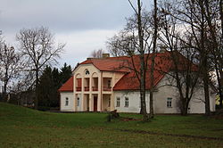
Nabala Manor
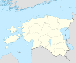
Nabala is located in Estonia
Nabala
Location in Estonia
Coordinates: 59°16′24″N 24°52′22″E / 59.27333°N 24.87278°E / 59.27333; 24.87278Coordinates: 59°16′24″N 24°52′22″E / 59.27333°N 24.87278°E / 59.27333; 24.87278
Country  Estonia
County Flag of et-Harju maakond.svg Harju County
Municipality Flag of Kiili.svg Kiili Parish
Population (2009[1])
 - Total 147

Nabala is a village in Kiili Parish, Harju County, in northern Estonia, located about 20 km southeast of Tallinn. It has a population of 147 (as of 2009).[1]

Estonian largest karst area (80.8 km²) is located around Nabala.

References

External links


Wikimedia Foundation. 2010.

Игры ⚽ Нужна курсовая?

Look at other dictionaries:

  • Nabala — ist ein Titularbistum der römisch katholischen Kirche. Es geht zurück auf ein spätantikes Bistum in der römischen Provinz Mauretania Caesariensis im Norden des heutigen Algerien. Liste der Titularbischöfe Paulo Garbinati (1669–?) Alexandre de… …   Deutsch Wikipedia

  • nabala- — s. nabalō ; …   Germanisches Wörterbuch

  • Bir Nabala — Infobox Palestinian Authority muni name=Bir Nabala imgsize=250 caption= arname=بئر نبالا meaning= founded= type=mund typefrom= altOffSp=Beer Nabala altUnoSp= governorate=jl latd=31|latm=51|lats=06.09|latNS=N longd=35… …   Wikipedia

  • Beit Nabala — Infobox Former Arab villages in Palestine name=Beit Nabala imgsize= caption= arname=بيت نبالا meaning= altSp=Bayt Nabala district=rl population=2,310 popyear=1945 area=15,051 areakm= date=May 13, 1948 cause=A *= **= curlocl=Kfar Truman, and Beit… …   Wikipedia

  • Bir Nabala — Original name in latin Br Nabl Name in other language Bi r Nabala, Bir Nabala, Bi’r Nabl Br Nabl byr nbala State code PS Continent/City Asia/Hebron longitude 31.8508 latitude 35.2036 altitude 759 Population 4776 Date 2012 01 18 …   Cities with a population over 1000 database

  • Kidnapping of Nachshon Wachsman — Location West Bank Date October 1994 Attack type Kidnapping, Shooting attack Death(s) 2 Israeli soldiers (Nachshon Wachsman and one Matka …   Wikipedia

  • Highway 60 (Israel) — Highway 60 (Hebrew: כביש 60‎, Kvish Shishim ) is a north south intercity road in Israel and the West Bank that stretches from Beersheba to Nazareth.[citation needed] Contents …   Wikipedia

  • Exode palestinien de Lydda et Ramle — 31°56′30.01″N 34°52′41.83″E / 31.9416694, 34.8782861 …   Wikipédia en Français

  • Жертвы межнационального противостояния в подмандатной Палестине до Арабо-Израильской войны 1948-49 г.г. — Жертвы межнационального противостояния в подмандатной Палестине до Арабо Израильской войны 1948 49 г.г. Жертвы межнационального противостояния в подмандатной Палестине до Арабо Израильской войны 1948 49 г.г. Содержание 1 Исторический фон 1.1 1920 …   Википедия

  • District of Ramle — The District of Ramle was an administrative sub district, a division of the Lydda district of the British Mandate of Palestine. The sub district s main city was Ramle. Its total population in 1944 was estimated at 123,490, of which 88,560 were… …   Wikipedia

Share the article and excerpts

Direct link
Do a right-click on the link above
and select “Copy Link”