Mu River (Hokkaidō)

Mu River (Hokkaidō)
Mu River (Mu-kawa)
鵡川
River
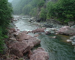
Red and Blue Boulder Gorge (赤岩青巌峡 Aka-iwa-sei-gan-kyō?) in Shimukappu (July 2000)
Country Japan
State Hokkaidō
Regions Iburi, Kamikawa
District Yūfutsu
Municipalities Mukawa, Shimukappu
Source Mount Karifuri
 - location Shimukappu, Hokkaidō, Japan
 - elevation 740 m (2,428 ft)
 - coordinates 43°1′41″N 142°41′4″E / 43.02806°N 142.68444°E / 43.02806; 142.68444
Mouth Pacific Ocean
 - location Mukawa, Hokkaidō, Japan
 - elevation 0 m (0 ft)
 - coordinates 42°33′45″N 141°55′1″E / 42.5625°N 141.91694°E / 42.5625; 141.91694
Length 135 km (84 mi)
Basin 1,270 km2 (490 sq mi)
Discharge
 - average 50.44 m3/s (1,781 cu ft/s)

Mu River (鵡川 Mu-kawa?) is a river in Hokkaidō, Japan.

Course

The Mu River rises on the slopes of Mount Karifuri in the Hidaka Mountains.[1] It flows South and West until it reaches the Pacific Ocean at Mukawa.

References

  1. ^ "鵡川". Ministry of Land,Infrastructure and Transport and Tourism Hokkaido Regional Development Bureau. http://www.hkd.mlit.go.jp/zigyoka/z_kasen/kawa/pro_mukawa.html. Retrieved 2009-05-04. 

Wikimedia Foundation. 2010.

Игры ⚽ Нужно решить контрольную?

Look at other dictionaries:

  • Hokkaido Sapporo Minami High School — (北海道札幌南高等学校, Hokkaidō Sapporo Minami Kōtō Gakkō) is a high school in Chuo ku, Sapporo, Hokkaidō, Japan, founded in 1895. It is one of the top high schools in Hokkaido.(Deviation is No.1)[citation needed] There are approximately 1,100 students… …   Wikipedia

  • Hokkaido — /hawk kuy daw /; Eng. /ho kuy doh/, n. a large island in N Japan. 5,660,000; 30,303 sq. mi. (78,485 sq. km). Formerly, Yezo. * * * formerly Yezo Island (pop., 2000 prelim.: 5,683,000) and province, northern Japan. Northernmost of the four main… …   Universalium

  • Ishikari River — River, Hokkaido, Japan. Rising near the centre of the Kitami Mountains, it flows southwest to empty into Ishikari Bay of the Sea of Japan (East Sea). It is 275 mi (442 km) long, the second longest river in Japan. Its name is derived from the Ainu …   Universalium

  • Mu River — For the Mu River in Hokkaidō, Japan, see Mu River (Hokkaidō). Coordinates: 21°56′N 95°38′E / 21.933°N 95.633°E / 21.933; 95.633 …   Wikipedia

  • Asahikawa, Hokkaidō — Asahikawa 旭川   Core city   旭川市 …   Wikipedia

  • Obihiro, Hokkaidō — Obihiro 帯広   City   …   Wikipedia

  • Chitose River — Coordinates: 43°07′05″N 141°33′24″E / 43.11806°N 141.55667°E / 43.11806; 141.55667 …   Wikipedia

  • Shiraoi, Hokkaidō — Infobox City Japan Name= Shiraoi JapaneseName= 白老町 Map Region= Hokkaidō Prefecture= Hokkaidō (Iburi) District=Shiraoi Area km2= 425.75 PopDate=31 May 2008 Population= 20,3731 Density km2=47.86 Coords= coord|42|33|N|141|21|E|region:JP type:city… …   Wikipedia

  • Shizunai River — Geobox|River name = Shizunai River native name = Shizunai gawa other name = 静内川 category = River etymology = Ainu language: Shiputnai A marsh at the origin of the Ainu or Shuttonai A marsh with lots of grapes or Shutnai A river at the foot of a… …   Wikipedia

  • Mitsuishi River — Coordinates: 42°14′40″N 142°34′11″E / 42.24444°N 142.56972°E / 42.24444; 142.56972 …   Wikipedia

Share the article and excerpts

Direct link
Do a right-click on the link above
and select “Copy Link”