Mount Kupreanof

Mount Kupreanof
Mount Kupreanof

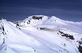
Steam plumes (center) rising from a prominent fumarole on the upper south-southwest flanks of Mount Kupreanof.
Elevation 1,895 m (6,217 ft)
Listing List of volcanoes in the United States
Location
Location Lake and Peninsula Borough, Alaska, United States
Coordinates 56°06′36″N 159°47′49″W / 56.11°N 159.797°W / 56.11; -159.797Coordinates: 56°06′36″N 159°47′49″W / 56.11°N 159.797°W / 56.11; -159.797
Geology
Type Stratovolcano
Volcanic arc/belt Aleutian Arc
Last eruption 1987

Mount Kupreanof is a stratovolcano on the Alaska Peninsula, United States. It is the largest and the northeasternmost in a group of five volcanoes opposite from Stepovak Bay. Mount Kupreanof displays extremely strong fumarole activity and its latest eruption in 1987 produced minor steam and ash emission.[1] This is the only known historical eruption from Mount Kupreanof.

References


Wikimedia Foundation. 2010.

Игры ⚽ Поможем решить контрольную работу

Look at other dictionaries:

  • Kupreanof Island — Infobox Islands name = Kupreanof image caption = image size = locator Location map|Alaska|lat=56.8|long= 133.416667 map custom = yes native name = native name link = nickname = location = coordinates = coord|56|48|N|133|25|W|display=inline… …   Wikipedia

  • Liste von Vulkanen in den USA —  Karte mit allen Koordinaten: OSM, Google oder …   Deutsch Wikipedia

  • Volcanes de la Tierra — Anexo:Volcanes de la Tierra Saltar a navegación, búsqueda Contenido 1 Afganistán 2 Alemania 3 Antártica 4 …   Wikipedia Español

  • United States — <p></p> <p></p> Introduction ::United States <p></p> Background: <p></p> Britain s American colonies broke with the mother country in 1776 and were recognized as the new nation of the United States… …   The World Factbook

  • Anexo:Islas de los Estados Unidos — Este Anexo:Islas de los Estados Unidos recoge en forma de tabla las islas de los Estados Unidos, ordenadas por área. Incluye todas las islas con una superficie de más de 70 km2, aunque puede estar incompleta. No incluye penínsulas que… …   Wikipedia Español

  • Revillagigedo Island — Blick auf Ketchikan Gewässer Pazifischer Ozean Inselgruppe …   Deutsch Wikipedia

  • Kuiu Island — Infobox Islands name = Kuiu image caption = image size = locator Location map|Alaska|lat=56.466667|long= 134.016667 map custom = yes native name = native name link = nickname = location = Pacific Ocean coordinates =… …   Wikipedia

  • Alaska Panhandle — Der Alaska Panhandle Der Alaska Panhandle (deutsch etwa „Alaska Landzipfel“, wortwörtliche Bedeutung „Alaska Pfannenstiel“, wegen der charakteristischen Form des Gebiets) ist die Bezeichnung für den östlich des 141. westlichen Längengrads… …   Deutsch Wikipedia

  • Русская Америка — владения Российской империи 1799  1867 …   Википедия

Share the article and excerpts

Direct link
Do a right-click on the link above
and select “Copy Link”