- Mount Kamui (Lake Mashū caldera)
-
Mount Kamui カムイヌプリ 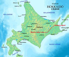
Map of Hokkaido showing location of Mount Kamui and Lake Mashū.Elevation 857 m (2,812 ft) Listing List of mountains and hills of Japan by height Translation mountain of the gods (Ainu) Location Location Hokkaido, Japan Range Daisetsuzan Volcanic Group Coordinates 43°34′20″N 144°33′39″E / 43.57222°N 144.56083°ECoordinates: 43°34′20″N 144°33′39″E / 43.57222°N 144.56083°E Topo map Geographical Survey Institute 25000:1 摩周湖南部, 50000:1 摩周湖 Geology Type stratovolcano Volcanic arc/belt Kurile arc Last eruption 970 AD ± 100 years Climbing Easiest route Hike Mount Kamui (カムイヌプリ Kamui-nupuri [1] ), also Kamuinupuri or Mount Mashū, a potentially active volcano, is a parasitic stratovolcano of the Mashū caldera (itself originally a parasitic cone of Lake Kussharo)[2][3][4] located in the Akan National Park of Hokkaido, Japan.
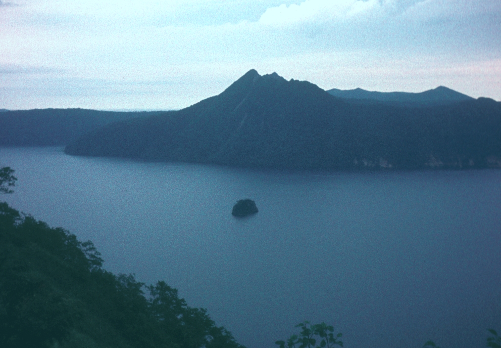
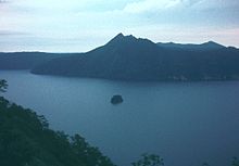 Mount Kamui rising above Lake Mashū.
Volcanism
Mount Kamui rose on the rim of 6 km-wide Mashū caldera, about four thousand years ago, after the collapse of Mashū volcano. Its last eruption took place about 1000 years ago.[5]
Tourism
Hikers can follow a 7.2 km wooded trail to the peak of the mountain, walking along the ridge of the caldera, which is a 300-m vertical drop to the surface of the Lake Mashū, offering spectacular views.[6]
References
- ^ "Kamui-nupuri: Japan". Geograpnical Names. http://www.geographic.org/geographic_names/name.php?uni=-347044&fid=3230&c=japan. Retrieved 2011-03-08.
- ^ "Geospatial Information Authority of Japan". http://www.gsi.go.jp/ENGLISH/index.html. Retrieved 2011-03-08.
- ^ "KAMUINUPURI". Quaternary Volcanoes of Japan, Geological Survey of Japan, AIST, 2006. http://riodb02.ibase.aist.go.jp/strata/VOL_JP/EN/vol/220d.htm. Retrieved 2011-03-08.
- ^ "Mashu". Global Volcanism Program, Smithsonian National Museum of Natural History. http://www.volcano.si.edu/world/volcano.cfm?vnum=0805-081. Retrieved 2011-03-08.
- ^ "Mashu caldera, Japan". Volcano Photos. http://www.geographic.org/photos/volcanoes/volcano_photos_41.html. Retrieved 2011-03-08.
- ^ "カムイヌプリ(摩周岳)( 857m) [第一展望台コース". 一人歩きの北海道山紀行. http://sakag.web.infoseek.co.jp/masyu.htm. Retrieved 2011-03-08.
Categories:- Mountains of Hokkaidō
- Volcanoes of Hokkaidō
- Stratovolcanoes
- Potentially active volcanoes

Wikimedia Foundation. 2010.