- Pico do Fogo
-
Pico do Fogo 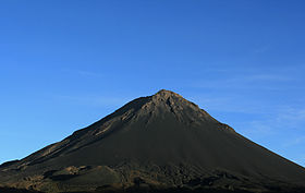
Elevation 2,829 m (9,281 ft) [1] Prominence 2,829 m (9,281 ft) Listing Country high point
Ultra
List of mountains in Cape VerdeLocation Fogo, Cape Verde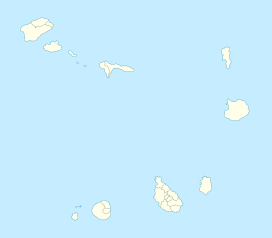
 Pico do Fogo
Coordinates 14°57′00″N 24°20′30″W / 14.95°N 24.34167°WCoordinates: 14°57′00″N 24°20′30″W / 14.95°N 24.34167°W[1] Geology Type Stratovolcano Last eruption 1995 Pico do Fogo pronounced: [ˈpiku du ˈfoɡu] is the highest peak of Cape Verde, rising to 2,829 metres (9,281 ft) above sea level. It is an active stratovolcano lying on the island of Fogo. The main cone last erupted in 1675, causing mass emigration from the island, while a subsidiary vent erupted in 1995. The only deadly eruption was in 1847 when earthquakes generated in all the island claimed several lives.
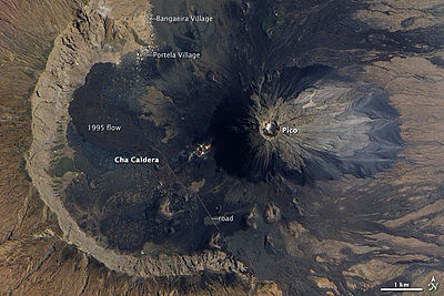
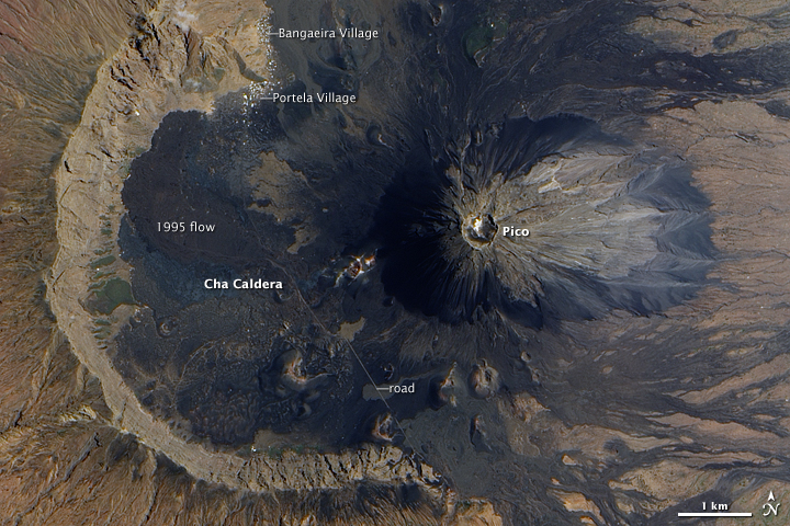
The mountain's slopes are used to grow coffee, while its lava is used as building material. Near its peak is a caldera and a small village, Chã das Caldeiras, is inside this caldera.
1995 eruption
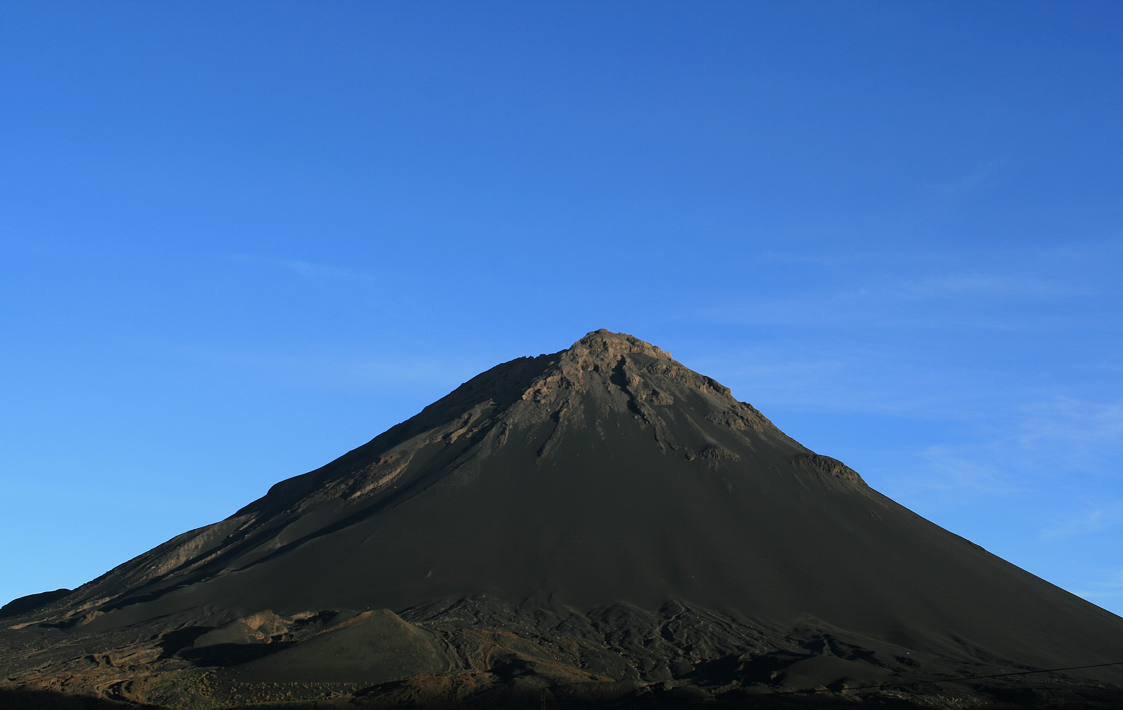
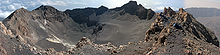 Pico de Fogo (caldera).
The eruption began on the night of 2–3 April, covering the island with a cloud of ash.[2] Residents were evacuated from Chã das Caldeiras, as their homes were destroyed.[3]
A team of United States Geological Survey (USGS) volcanologists has been monitoring an eruption that began just after midnight on April 3 on Fogo. Frank Trusdell from the Hawaiian Volcano Observatory (HVO) and Richard Moore (former geologist on the staff of the HVO) from our Denver, Colorado office arrived in Fogo on April 10 in response to a request from the State Department. Our Volcano Disaster Assistance Program, funded by U.S. AID and the USGS, provides assistance in volcanic crises or emergencies around the world. This report is based mainly on their daily communications from Fogo, and an earlier report on the eruption sent to the Smithsonian Institution's Global Volcanism Network by geologists J. Gaspar and N. Wallenstein from the University of the Azores. They were on Fogo when the eruption began.[2]
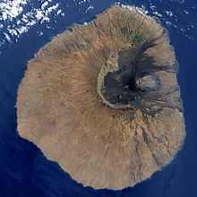 Satellite image of Fogo.
Like Hawaii, Fogo is a "hot-spot" volcanic island. It last erupted in 1951. It is the youngest and most active volcano in the Cape Verde Islands. The Cape Verde Islands, a short chain of volcanic islands that generally are younger at the western end, formed as the African Plate moved towards the east over the hotspot in much the same way that the Hawaiian Ridge formed as the Pacific Plate moved west-northwestward over a hotspot.[2]
Unlike the island of Hawaii, Fogo consists of a single volcano, so the island is nearly round and about 25 kilometers (16 mi) in diameter. The large summit caldera (about 10 kilometers in the north-south direction and 7 kilometers in the east-west direction) is not located in the center of the island, but rather towards its northeastern corner. The caldera is bounded by steep near-vertical fault scarps on the north, west, and south sides but is breached to the east where lava can flow to the coast. The current north-northeast-trending eruptive fissures are located along the western flank of a large cone named Pico, which formed inside the caldera between about 1500 and 1760.[2]
Residents reported that the eruption was heralded by small earthquakes which began about six days prior to the outbreak of lava. These earthquakes increased in size and frequency through April 2, and a particularly strong one was reported at about 8 p.m., some four hours before the eruption apparently began. Just after midnight, the fissures opened on the flank of Pico. One resident said it looked as if the cone had "been cut by a knife." The eruption began with Strombolian (moderately explosive) activity, quickly followed by a curtain-of-fire fountain that fed a flow which cut off the road to the village of Portela by 2 a.m. The 1,300 people living inside the caldera fled during the night to the safety of villages on the north coast. No one was killed; about 20 people required medical attention, although our reports do not indicate the nature or severity of their injuries. We suspect that they inhaled volcanic fumes and ash particles, which caused difficulties in breathing.[2]
During the day on April 3, the island was covered by a thick cloud of dark ash that reached 2.5 to 5 kilometers high. The initial flows were pahoehoe lava, although their extent was apparently small. The violent eruption produced lava bombs up to 4 meters across that were ejected as far as 500 meters from the vents. On April 4, lava fountains reached 400 meters high beneath a cloud of ashes about 2 kilometers high. A new scoria cone formed that was open to the southwest and fed a growing 'a'a flow. On April 5, the new 'a'a flow reached the western caldera wall and destoyed about five houses and the main water reservoir. During these first few days, civil authorities evacuated about 3,000 people.[2]
 Chã das Caldeiras and main ash cone, Fogo, 2009
The eruption has become more steady following the first few days, and moderate, Hawaiian-style lava fountains about 100-120 meters high have built a spatter cone that now stands more than 140 meters high. The flows have been 'a'a and have flowed towards the west to the caldera wall and then turned north. These flows have advanced episodically as pressure builds from ponding and thickening of the flows. On April 13, a second 'a'a flow began to cover an earlier, stagnant 'a'a flow and was almost entirely on top of the earlier flow until April 15, when it spread out and destroyed another home. Cinder fell as far as two kilometers south of the vents on April 15. By the 17th, the flow had advanced to within 420 meters of the nearest house in the village of Portela, but was stagnant again.[2]
On April 18, the portable sesismometer installed by the USGS team began to record much stonger volcanic tremor (continuous ground shaking) that indicated a change in eruptive style from fire fountains back to Strombolian activity. Spatter was discharged every 3-8 seconds with loud gas bursts. In addition, the eruptive rate increased and the upper 300 meters of the channel was largely pahoehoe lava. The eruption rates, estimated from the dimensions and flow rates in the channel, are between 4 and 8.5 million cubic meters per day. For comparison, the current eruption at Kilauea has been producing about one-half million cubic meters per day. In comparison, eruption rates exceeded 10 and 20 million cubic meters per day during the high-fountain phases of the Kilauea eruption (1983-1986) and the initial phases of the 1984 Mauna Loa eruption, respectively. Despite the increased eruption rate at Fogo during this time period, the flow fronts advanced only a few meters as the flows thickened.[2]
During the night of April 18, a series of large, explosive bursts occurred that may have followed collapse of parts of the cone into the vents and subsequent explosive clearing of the debris. By morning, the activity had returned to fire fountains, and the seismic record was much quieter. The lava flows continued to thicken, and lava ponded along the central channel. As pressure builds within the flow, a rapid advance of the flow into Portela seems likely.[2]
The structure of Fogo, with the caldera open to the sea on the east side, is caused by processes similar to those that shape Hawaiian and other basaltic volcanoes. The structure results from the sliding of the east flank of the volcano in much the same way that the south flank of Kilauea slides towards the ocean. In Hawaii, the most similar structure can be seen on Kohala Volcano, where a landslide structure has moved the northeastern side of the volcano down and away from the summit. The indentation in the coastline between Waipio Valley and Akoakoa Point mark the edges of the slide. Reunion Island in the Indian Ocean has a structure most similar to Fogo, although Reunion consists of an older western volcano and an active eastern volcano named Piton de la Fournaise, which has a structure very similar to that of Fogo. It, too, has been shaped by landslides that breached its caldera on the east side, and, like Fogo, has had numerous historic-aged lava flows that reached the sea along its eastern coast.[2]
USGS scientists are presently training several Cape Verde geologists in the use and interpretation of the seismometer records, and in the assessment of the eruptive activity and lava flows for future hazards mitigation. These flows are presently ponding within the western part of the caldera, but if the eruption were to continue at similar eruptive rates for another month or so, the lava flows could thicken enough and spill out of the caldera on the east side and advance to the coast.[2]
References
- ^ a b "Fogo". Global Volcanism Program, Smithsonian Institution. http://www.volcano.si.edu/world/volcano.cfm?vnum=1804-01=. Retrieved 2011-04-11.
- ^ a b c d e f g h i j k "Volcano Watch: Fogo Volcano, Cape Verde Islands". Hawaiian Volcano Observatory. April 21, 1995. http://hvo.wr.usgs.gov/volcanowatch/1995/95_04_21.html. Retrieved 2007-10-17.
- ^ "Fogo Caldera". MTU Volcanoes Page. Michigan Technological University. http://www.geo.mtu.edu/volcanoes/africa/fogo/. Retrieved 2007-10-17.
External links
- Fogo, Cape Verde Islands at NASA Earth Observatory
- Fogo Summary at Smithsonian Global Volcanism Program
Categories:- Fogo, Cape Verde
- Mountains of Cape Verde
- Volcanoes of Cape Verde
- Stratovolcanoes


Wikimedia Foundation. 2010.