- Mont-Noble
-
Mont-Noble Nax village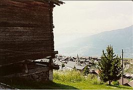
Country Switzerland 
Canton Valais District Hérens 46°13′N 07°25′E / 46.217°N 7.417°ECoordinates: 46°13′N 07°25′E / 46.217°N 7.417°E Population 876 (Dec 2009)[1] - Density 20 /km2 (53 /sq mi) Area 43.0 km2 (16.6 sq mi) Elevation 1,286 m (4,219 ft) Postal code 1973 SFOS number 6090 Website Mont-Noble.ch
SFSO statistics
 Mont-Noble
View map of Mont-Noble Mont-Noble is a municipality in the district of Hérens in the canton of Valais in Switzerland. It was created on 1 January 2011 through the merger of the municipalities of Mase, Vernamiège and Nax.[2]
Contents
History
Mase is first mentioned about 1100 as villa Magis. Until 1902 it was known as Mage.[3] Nax is first mentioned around 1001-1100 as Nas.[4] Nax's village church collapsed in 1909 during a service, killing 31 and injuring 50.
Geography
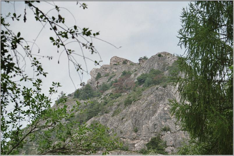
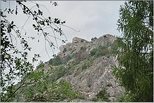 Rocky promontory near Nax
Mont-Noble has an area, as of 2011[update], of 43 square kilometers (17 sq mi). Of this area, 32.7% is used for agricultural purposes, while 39.5% is forested. Of the rest of the land, 2.8% is settled (buildings or roads) and 25.0% is unproductive land.[5]
The village of Mase is located in the Hérens district on the right bank of the Borgne and the left bank of the Rhone in the Val d'Hérens at an elevation of 1,345 m (4,413 ft).
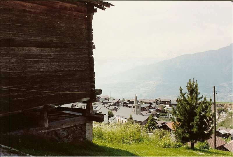
Nax is situated at the entrance to the Hérens valley near a rocky promontory which may provided its name, from the Latin: nasus, nose.
Demographics
Mont-Noble has a population (as of December 2009[update]) of 876.[1] As of 2008[update], 7.2% of the population are resident foreign nationals.[6] Over the last 10 years (1999–2009 ) the population has changed at a rate of 10.6%. It has changed at a rate of 15.5% due to migration and at a rate of -6.2% due to births and deaths.[5]
Most of the population (as of 2000[update]) speaks French (92.8%) as their first language, German is the second most common (5.2%) and Italian is the third (0.8%).[5]
The age distribution of the population (as of 2000[update]) is children and teenagers (0–19 years old) make up 17.3% of the population, while adults (20–64 years old) make up 57.6% and seniors (over 64 years old) make up 25.1%.[5]
As of 2000[update] the average number of residents per living room was 0.56 which is less people per room than the cantonal average of 0.63 per room.[5] In this case, a room is defined as space of a housing unit of at least 4 m² (43 sq ft) as normal bedrooms, dining rooms, living rooms, kitchens and habitable cellars and attics.[7] About 83.8% of the total households were owner occupied, or in other words did not pay rent (though they may have a mortgage or a rent-to-own agreement).[8]
As of 2009[update], the construction rate of new housing units was 6.8 new units per 1000 residents.[5] The vacancy rate for the municipality, in 2010[update], was 1.49%.[5]
Historic Population
The historical population is given in the following chart:[3][4][9]

Sights
The entire village of Mase is designated as part of the Inventory of Swiss Heritage Sites[10]
Economy
As of 2010[update], Mont-Noble had an unemployment rate of 5.7%. As of 2008[update], there were 27 people employed in the primary economic sector and about 16 businesses involved in this sector. 26 people were employed in the secondary sector and there were 8 businesses in this sector. 93 people were employed in the tertiary sector, with 31 businesses in this sector.[5]
Of the working population, 11.8% used public transportation to get to work, and 67.1% used a private car.[5]
References
- ^ a b Swiss Federal Statistical Office, MS Excel document – Bilanz der ständigen Wohnbevölkerung nach Kantonen, Bezirken und Gemeinden (German) accessed 25 August 2010
- ^ Amtliches Gemeindeverzeichnis der Schweiz published by the Swiss Federal Statistical Office (German) accessed 19 July 2011
- ^ a b Mase in German, French and Italian in the online Historical Dictionary of Switzerland.
- ^ a b Nax in German, French and Italian in the online Historical Dictionary of Switzerland.
- ^ a b c d e f g h i Swiss Federal Statistical Office accessed 08-September-2011
- ^ Swiss Federal Statistical Office - Superweb database - Gemeinde Statistics 1981-2008 (German) accessed 19 June 2010
- ^ Eurostat. "Housing (SA1)" (pdf). Urban Audit Glossary. 2007. p. 18. http://www.bfs.admin.ch/bfs/portal/en/index/international/22/lexi.Document.116365.pdf. Retrieved 12 February 2010.
- ^ Urban Audit Glossary pg 17
- ^ Federal Statistical Office STAT-TAB Bevölkerungsentwicklung nach Region, 1850-2000 (German) accessed 29 January 2011
- ^ "Kantonsliste A-Objekte" (in German). KGS Inventar. Federal Office of Civil Protection. 2009. http://www.bevoelkerungsschutz.admin.ch/internet/bs/de/home/themen/kgs/kgs_inventar/a-objekte.html. Retrieved 25 April 2011.
Les Agettes | Ayent | Evolène | Hérémence | Mont-Noble | Saint-Martin | Vex
Valais | Districts of Canton Valais | Municipalities of the canton of Valais
 Categories:
- Municipalities of Valais
- Municipalities of Switzerland


Wikimedia Foundation. 2010.