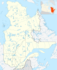
- Saint-Maxime-du-Mont-Louis, Quebec
-
Location of Saint-Maxime-du-Mont-Louis in Quebec
Saint-Maxime-du-Mont-Louis is a municipality in Quebec. Located in the administrative region of Gaspésie–Îles-de-la-Madeleine and the regional county municipality of La Haute-Gaspésie, the municipality comprises the communities of Mont-Louis, Ruisseau-des-Olives, L'Anse-Pleureuse, Les Côtes-du-Portage and Gros-Morne.
The municipality had a population of 1,194 in the Canada 2006 Census.[1]
Climate
Climate data for Saint-Maxime-du-Mont-Louis Month Jan Feb Mar Apr May Jun Jul Aug Sep Oct Nov Dec Year Record high °C (°F) 12
(54)15.6
(60.1)20
(68)30
(86)31
(88)36.7
(98.1)34.5
(94.1)35.6
(96.1)32.2
(90.0)26.7
(80.1)21.7
(71.1)17.8
(64.0)36.7
(98.1)Average high °C (°F) −7.2
(19.0)−6.1
(21.0)−0.2
(31.6)5.7
(42.3)12.8
(55.0)19.1
(66.4)22.1
(71.8)20.9
(69.6)15.8
(60.4)9.3
(48.7)3
(37)−3.6
(25.5)7.6 Daily mean °C (°F) −11.7
(10.9)−10.6
(12.9)−4.7
(23.5)1.8
(35.2)8.1
(46.6)14
(57)17.3
(63.1)16.3
(61.3)11.4
(52.5)5.5
(41.9)−0.3
(31.5)−7.4
(18.7)3.3 Average low °C (°F) −16.1
(3.0)−15.1
(4.8)−9.1
(15.6)−2.1
(28.2)3.3
(37.9)8.9
(48.0)12.5
(54.5)11.7
(53.1)7
(45)1.7
(35.1)−3.5
(25.7)−11.2
(11.8)−1 Record low °C (°F) −35
(−31)−30
(−22)−25.6
(−14.1)−17
(1)−10
(14)−1.1
(30.0)1.1
(34.0)1.7
(35.1)−3.3
(26.1)−9.4
(15.1)−20
(−4)−27.8
(−18.0)−35
(−31)Precipitation mm (inches) 64.1
(2.524)47.6
(1.874)64.8
(2.551)62.1
(2.445)66.7
(2.626)76
(2.99)84.7
(3.335)91.6
(3.606)83.5
(3.287)94.1
(3.705)70
(2.76)79.8
(3.142)885
(34.84)Source: Environment Canada[2] References
Coordinates: 49°13′52″N 65°43′55″W / 49.231°N 65.732°W
Categories:- Municipalities in Quebec
- Incorporated places in Gaspésie–Îles-de-la-Madeleine
- Quebec geography stubs
Wikimedia Foundation. 2010.

