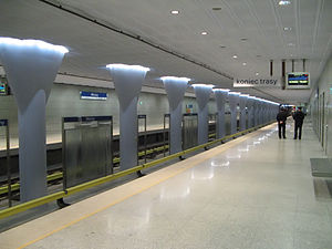
- Młociny metro station
-
Młociny 
Station statistics Coordinates 52°17′28″N 20°55′44″E / 52.2911°N 20.9289°ECoordinates: 52°17′28″N 20°55′44″E / 52.2911°N 20.9289°E Other information Opened 2008 Code A23 Owned by ZTM Services Preceding station Warsaw Metro Following station Terminus Line 1 Wawrzyszewtoward KabatyMłociny is a Warsaw Metro station. It became the 21st station of the Warsaw Metro when it opened on 25 October 2008. It is the northern end of the first metro line and also serves as a major transfer point between different modes of transport in Warsaw, thanks to a large bus and tram interchange that was previously called Huta. It is also situated near the tram depot Żoliborz. There is also a proposed tram link due to be built in around five years linking Młociny with the North-East of the city.
References
External links
 Media related to Młociny metro station at Wikimedia Commons
Warsaw Metro Line 1
(north to south)Młociny • Wawrzyszew • Stare Bielany • Słodowiec • Marymont • Plac Wilsona • Dworzec Gdański • Ratusz Arsenał • Świętokrzyska • Centrum • Politechnika • Pole Mokotowskie • Racławicka • Wierzbno • Wilanowska • Służew • Ursynów • Stokłosy • Imielin • Natolin • KabatyLine 2
(west to east)Rondo Daszyńskiego • Rondo ONZ • Świętokrzyska • Nowy Świat • Powiśle • Stadion • Dworzec Wileński
This Warsaw Metro-related article is a stub. You can help Wikipedia by expanding it.
