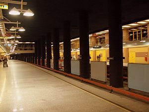
- Centrum metro station
-
Centrum Station statistics Coordinates 52°13′53″N 21°0′38″E / 52.23139°N 21.01056°ECoordinates: 52°13′53″N 21°0′38″E / 52.23139°N 21.01056°E Other information Opened 1998 Code A-13 Owned by ZTM Services Preceding station Warsaw Metro Following station Świętokrzyskatoward MłocinyLine 1 Politechnikatoward KabatyMetro Centrum is a Warsaw Metro station located under the Plac Defilad square in the borough of Śródmieście, next to the Roman Dmowski roundabout, where two main streets, Marszałkowska and Aleje Jerozolimskie, intersect. It is located close to the Palace of Culture and Science and Warsaw Central Rail Station. It has two levels, the lower one with metro platforms and the upper one is a shopping gallery.
See also
- Plac Konstytucji: a planned station south of Centrum
References
External links
 Media related to Centrum metro station at Wikimedia Commons
Warsaw Metro Line 1
(north to south)Młociny • Wawrzyszew • Stare Bielany • Słodowiec • Marymont • Plac Wilsona • Dworzec Gdański • Ratusz Arsenał • Świętokrzyska • Centrum • Politechnika • Pole Mokotowskie • Racławicka • Wierzbno • Wilanowska • Służew • Ursynów • Stokłosy • Imielin • Natolin • KabatyLine 2
(west to east)Rondo Daszyńskiego • Rondo ONZ • Świętokrzyska • Nowy Świat • Powiśle • Stadion • Dworzec Wileński
This Warsaw Metro-related article is a stub. You can help Wikipedia by expanding it.

