- Mitsuzawa-kamichō Station
-
Misuzawa-kamichō Station三ツ沢上町駅
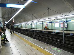
Misuzawa-kamichō Station platform Location Prefecture Kanagawa
(See other stations in Kanagawa)City Yokohama Ward Kanagawa Neighborhood etc. Misuzawa-kamichō 5-9 Postal Code 221 - 0856 (in Japanese) 横浜市神奈川区三ツ沢上町5-9 History Year opened 1985 Rail services Station number(s) B22 Operator(s) Yokohama Municipal Subway Line(s) Blue Line Statistics 7,281 passengers/day 2008 Misuzawa-kamichō Station (三ツ沢上町駅 Misuzawa-kamichō-eki) is an underground metro station located in Kanagawa-ku, Yokohama, Kanagawa, Japan operated by the Yokohama Municipal Subway’s Blue Line (Line 3). It is 24.8 kilometers from the terminus of the Blue Line at Shōnandai Station.
Contents
History
Misuzawa-kamichō Station was opened on March 14, 1985. Platform screen doors were installed in April 2007.
Lines
Station layout
Misuzawa-kamichō Station has a dual opposed side platforms serving two tracks, located five stories underground. The station was constructed at a depth of 30.5 meters using the NATM method, with rounded tunnels unusual for Japanese metro systems.
Platforms
■Blue Line (Yokohama) Yokohama, Kannai, Totsuka, Shōnandai ■Blue Line (Yokohama) Shin-Yokohama, Azamino Adjacent stations
« Service » Yokohama Subway Blue Line (B22) Mitsuzawa-shimochō (B21) - Katakurachō (B23) Surrounding area
- Yokohama National University
- Mitsuzawa Park and Mitsuzawa Stadium
- Yokohama Municipal Hospital
- Bugenji Temple
- Mitsuzawa Cemetery
References
- Harris, Ken and Clarke, Jackie. Jane's World Railways 2008-2009. Jane's Information Group (2008). ISBN 0-7106-2861-7
External links
- Mitsuzawa-kamichō Station (Blue Line) (Japanese)
Azamino – Nakagawa – Center-Kita – Center-Minami – Nakamachidai – Nippa – Kita Shin-Yokohama – Shin-Yokohama – Kishine-kōen – Katakurachō – Mitsuzawa-kamichō – Mitsuzawa-shimochō – Yokohama – Takashimachō – Sakuragichō – Kannai – Isezaki-chōjamachi – Bandōbashi – Yoshinochō – Maita – Gumyōji – Kamiōoka – Kōnan-Chūō – Kaminagaya – Shimonagaya – Maioka – Totsuka – Odoriba – Nakada – Tateba – Shimoiida – Shōnandai
Coordinates: 35°28′35.49″N 139°36′19.42″E / 35.476525°N 139.6053944°ECategories:- Railway stations in Kanagawa Prefecture
- Railway stations opened in 1985
- Stations of Yokohama City Transportation Bureau
- Blue Line (Yokohama)
- Kanagawa Prefecture railway station stubs
Wikimedia Foundation. 2010.

