- Milos (regional unit)
-
Milos
Περιφερειακή ενότητα
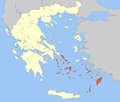
Μήλου— Peripheral unit — Municipalities of the Cyclades The Cyclades within Greece Coordinates: 36°35′N 24°25′E / 36.583°N 24.417°ECoordinates: 36°35′N 24°25′E / 36.583°N 24.417°E Country Greece Periphery South Aegean Area - Total 362.5 km2 (140 sq mi) Population (2001) - Total 9,396 - Density 25.9/km2 (67.1/sq mi) Milos (Greek: Περιφερειακή ενότητα Μήλου) is one of the peripheral units of Greece. It is part of the periphery of South Aegean. The peripheral unit covers the islands of Kimolos, Milos, Serifos, Sifnos and several smaller islands in the Aegean Sea.
Administration
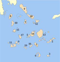
As a part of the 2011 Kallikratis government reform, the peripheral unit Milos was created out of the former Cyclades Prefecture. It is subdivided into 4 municipalities. These are (number as in the map in the infobox):[1]
References
Administrative division of the South Aegean Region Area: 5,286km² • Population: 302,686 (2001) • Capital: Ermoupoli  Regional unit of KalymnosRegional unit of KarpathosRegional unit of Kea-KythnosRegional unit of KosRegional unit of MilosRegional unit of ParosRegional unit of RhodesRegional unit of Santorini
Regional governor: Ioannis Machairidis • Website: www.pnai.gov.gr Categories:- South Aegean
- Regional units of Greece
- 2011 establishments in Greece
- Greece geography stubs
Wikimedia Foundation. 2010.


