- Miller's pier
-
Miller's pier Russian: пристань Миллера
regional rail
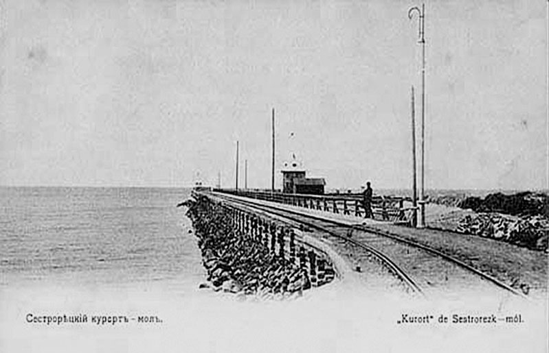
View to the Miller's pier in 1913Station statistics Coordinates 60°7′5″N 29°56′28″E / 60.11806°N 29.94111°ECoordinates: 60°7′5″N 29°56′28″E / 60.11806°N 29.94111°E Lines Miller's line Structure at-grade Other information Opened 1875 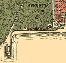 Station at the beginning of 20th centuries
Primorskaya Railway, Russia
Primorsky Rail Terminal - SestroretskLegend
Distances in kilometers
35.1 Dyuny 

34.1 Shkolnaya 

33.3 Line SPb-Sestr.-Beloostrov 
To Beloostrov 


33.1 Zavodskaya sestra cr. Z. s. 
Planned ferry line 
Miller's pier Gulf of Finland 


32.7 Kurort 


31.4 Sestroretsky Kyrort 


31.3 Trackside 

31.2 Line Miller's line 
Sestroretsk 
31.1 Yermolovsky prospect Sestroretsk 31.0 Yermolovskaya 

30.7 Sestroretsk armory 

30.2 Voskov street Sestroretsk Line Dubki horse-iron road (1847-bf 1870) Sestroretsk armory (1847-bf 1870) 
Dubkovsky pier 

35.1 Sestroretsk 
29.7 Liteyny bridge Vodoslivnoy channel Vyborg Saint Petersburg 
29.4 Sestroretsky crossover M10 highway 
33.3 Razliv 26.5 Tarkhovka 
26.3 Tarkhovskaya street Tarkhovka 26.1 Alexandrovskaya 24.0 Gorskaya 23.9 Gorskaya road interchange KAD 
22.1 Kaupilovo 
21.1 Aerodromnaya street To Gorskaya
23.3 Export goods for Spb Dam 


23.3 Lisy Nos, before 1928 To Kronshtadt before 1928 Gulf of Finland 


20.3 Lisy Nos 
18.8 Morskaya 
North-West Thermal Power Plant 15.2 Olgino 15.1 Konnolakhtinsky prospect Olgino 

17.1 Lakhta station Lakhta, (b. 1894) 12.1 Granichnaya street Lakhta 


200-metre pile bridge 1894–1924 
10.5 Lakhtinsky crossover build 1925 
lake Lakhtyinsky razliv 


Shunting loop Dum build 1894 later – Yakhtennaya pl. build 1980s 8.0 Shunting loop 2 verst build 1894 6.6 Planerny crossover Planernaya st. 


Kirovskaya Small October railway 


Sub Staraya Derevnya Line 4 

5,4 Staraya Derevnya 5.3 Torfyanaya doroga 4.4 Serebryakov pereulok 
3.5 Akademik Shimansky street 

1.3 Chyornaya rechka crossover 


1.0 Novaya Derevnya Objects 1893 
Severny factory 


0.8 Line Ozerki line 

Ozerki Kolomuagi 
Skachki 
Tovarnaya line Serdobolsky stop Flugov post 1924-1934 Finlyandsky Rail Terminal SPb-Sestr.-Beloostrov Finlyandsky Rail Terminal Flugov post 1924-1934 
Lanskaya Chernaya River 
0.6 Kolomyajskу bridge 


Primorsky - Goods 1904-1924 

0.0 Primorsky Rail Terminal To Summer Garden (Neva)
Railway line consists of single-track line tracksidesMiller's pier (Russian: при́стань Ми́ллера, Pristan Millera), is a railway station at the quay in Sestroretsky kurort, Russia.
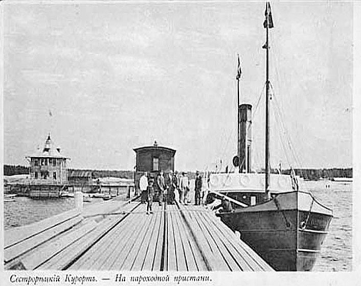
In harbour of Gulf of Finland from boulders the 50-metre dam was dumped. In an operating time the name "Miller's Harbour" was fixed to harbour. On bay coast in 1875 have laid a branch line to landing stage and the same year on it the first structures have gone.[1]
In 1899–1900 the Kurort's esplanade has been opened. To this event a line have surrounded with two low enclosure.[1]
References
Societies of the Sestroretsk railway,
Miller's line (1873-1886)Legend
Distances in kilometers
line Vyborg line 
Vyborg Zelenogorsk Solnechnoye 5.8 5.9 Sestra crossover 
6.3 
6.6 Beloostrov line Vyborg line Finlyandsky Rail Term. Lanskaya Pesochny 
Sestra river 

2.3 
1.8 Trackside 1871-1886 
line SPb-Sestr.-Beloostrov Kurort Planned ferry line 2.9 Miller's pier Gulf of Finland Trackside line SPb-Sestr.-Beloostrov Kurort 2.2 Sestroretsky kurort 1.7 1.0 


0.8 


0.6 


0.5 Factory bridge Zav. s. 


0.2 0.0 Sestroretsk railway station Sestroretsk (1871-1924) Sestroretsk armory 
lake Rasliw 
planned trackside 


Vodoslivnoy channel 


1.7 Sestroretsk 

1.7 Line Dubki horse-iron road Sestroretsk armory (1847-before 1870) Dubkovsky pier 
2.1 Liteyny bridge 3.5 Razliv 

3.6 line SPb-Sestr.-Beloostrov Finlyandsky Rail Term. Novaya derevnya Tarkhovka 

5.7 Tarkhovka pier Ships to Saint Petersburg (Gulf of Finland)
Miller's line railroad line includes Sestroretsk spur line- ^ a b Chepurin, Sergey; Arkady Nikolayenko (May 2007). "Sestroretsk and Primorskaya railways(Сестрорецкая и Приморская железные дороги)" (in ru). http://terijoki.spb.ru/trk_about.php3. http://terijoki.spb.ru/railway/rw_dir_sestr.php#red. Retrieved 21 February 2009.
Landing stages of Russian coast in Gulf of Finland North gulf coast (Leningrad Oblast) Miller's pier · 1875 - 19XX • Dubkovsky pier · 1847 - before 1870 • Tarkhovka pier • Lisy Nos pier · 1894 - 1928 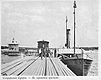
South gulf coast (Leningrad Oblast) Peterhof landing stage · 1XXX See also: Sea and river terminals, Yacht-clubs Categories:- Landing stages of Russian coast in Gulf of Finland

Wikimedia Foundation. 2010.