- Military Park (NLR station)
-
Military Park 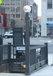
Station entrance at the south end of parkStation statistics Address Park Place
at Broad Street
Newark, New JerseyLines Connections NJT Bus: 13, 27, 39, 40, 41, 42, 43, 59, 62, 65, 66, 67, 70, 71, 72, 73, 76, 78, 79 and 108
ONE Bus: 24, 44Platforms 2 side platforms Tracks 2 Other information Opened 1935 Owned by New Jersey Transit Formerly Broad Street(1935-2005) Services Preceding station Newark Light Rail Following station Washington Streettoward Grove StreetGrove Street – Newark Penn Terminus Interior
Military Park Station is an underground station on the Newark City Subway Line (blue) of the Newark Light Rail. The station is owned and service is operated by New Jersey Transit. The station is located at the intersection of Raymond Boulevard, Park Place and Broad Street in Downtown Newark at Military Park. The station was opened in 1935 and called Broad Street Station. It was renamed so only one station in the system would carry the name Broad Street when Downtown Newark's stations (Penn Station and Broad Street) were connected by the Newark Light Rail Line. The station is decorated with beige tiles and colored tiles for borders, mosaics and street indicator signs. This station is not wheelchair accessible. The adjacent stations, Penn Station and Washington St. are handicap accessible.
Contents
History
In 1910, the Public Service Corporation planned to build two subway lines meeting at Broad Street (now Military Park). An additional north-south line would have connected Bridge Street to the north with Clinton Avenue near The Coast/Lincoln Park neighborhood near Lincoln Park. The proposed second segment of the Newark-Elizabeth Rail Link (NERL) together with the first segment, the Newark Light Rail would service this area. The existing Newark City Subway Line was built in the old Morris Canal bed with construction beginning in 1929 and service starting on the line on May 26, 1935.
Attractions
- Military Park
- New Jersey Historical Society
- Aljira Gallery
- Park Place Farmers Market
- Trinity and St. Phillips Cathedral
- East Coast Greenway (undeveloped)
- Lenape Trail (unmarked)
- shops and restaurants and hotels
Other Attractions
These attractions are less than a half mile from Military Park Station and not served by a closer station:
- Prudential Center
- Government Center:
- Newark City Hall
Transfers
Connections are available to the following lines:
- NJ Transit: 13, 27, 39, 40, 41, 42, 43, 59, 62, 65, 66, 67, 70, 71, 72, 73, 76, 78, 79 and 108
- ONE Bus: 24, 44
External links
- NJT Newark Light Rail station information page for Military Park
- Newark Light Rail schedule
- Broad Street entrance from Google Maps Street View
Coordinates: 40°44′14.42″N 74°10′16.13″W / 40.7373389°N 74.1711472°W
Categories:- Newark Light Rail stations
- Railway stations opened in 1935


Wikimedia Foundation. 2010.