- Mickfield
-
Coordinates: 52°12′43″N 1°07′37″E / 52.212°N 1.127°E
Mickfield 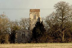
St. Andrew's church, Mickfield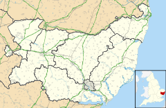
 Mickfield
Mickfield shown within SuffolkPopulation 200 [1] District Mid Suffolk Shire county Suffolk Region East Country England Sovereign state United Kingdom Police Suffolk Fire Suffolk Ambulance East of England EU Parliament East of England List of places: UK • England • Suffolk Mickfield is a village and civil parish in the Mid Suffolk district of Suffolk in eastern England. Located around five miles north-east of Stowmarket, in 2005 its population was 200.[1]
The Church of St Andrew was made redundant in the late 70's and was allowed to fall into disrepair. The building has now been restored by the ACT (Anglia Church Trust) and is being used by the community. The small brethren gospel hall was demolished in 2009, after 104 years, on completion of the new church building, Mickfield Evangelical Church. No longer known as a brethren church, the group are now affiliated with the FIEC (Fellowship of Independent Evangelical Churches).
References
- ^ a b Estimates of Total Population of Areas in Suffolk Suffolk County Council
http://www.mickfieldvillage.co.uk/
External links
 Media related to Mickfield at Wikimedia CommonsCategories:
- Suffolk geography stubs
- Villages in Suffolk
- Civil parishes in Suffolk
- Mid Suffolk


Wikimedia Foundation. 2010.