- Metamorfosi, Laconia
-
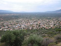 Panoramic view of the village by the foot of the mountain Koulochera.
The village of Metamorfosi (Greek: Μεταμόρφωση) is just 5 km from the center of Molaoi city, and about 78 km southeast of Sparta. The village is built at the foot of the mountain Koulochera on the outskirts of Parnonas, 120 meters in altitude and according to the latest census numbers Metamorfosis has only 555 residents.
Contents
History
It is believed that an ancient town named Lefki (Λεύκη) existed at the northern end of the Asopos plain and that a river flowed in the middle of this plain, by the name of Asopos or Lefki. In the devastating earthquake of 375 AD, the river disappeared underground forming the natural swallow hole (katavothra) at the north east end of the plain. Three distinct areas of interest are found in the flat outskirts of the village with worthy enough archeological finds that hold testament to the existence and development of ancient dwellings, occupying most likely the original site of the village. These areas are found near the public school and the cemetery and artifacts from the Roman and Byzantine times have been found there.
It appears that the early dwellers of Laconia were of a Pre-Hellenic race called Leleges who inhabited the region during the Bronze Age, and made a living by hunting and farming. In 3000 BC the Acheans, a Hellenic race, came from the north and settled in Laconia establishing strong commercial centers close to the shoreline. In 1100 BC, the Dorians invade the area and this period comes to be known as the Spartan Years that lasted until 146 BC. During this time these centers lose their autonomy and are brought under the "guardianship" of Sparta. In 146 BC, eighteen Laconic cities including Gythio, Asopos and Epidavros Limira, declare their independence from Sparta and establish an independent federation, the Union of the Free Laconians. The Romans who dominated the area in 27 AD, granted this federation many privileges and freedoms and the region of Epidavros Limira flourished greatly and experienced its own "golden age".
In 375 AD, severe earthquakes shake the Laconic lands and completely destroy major centers like Asopos and Epidavros Limira. In their place, the new focal city of Monemvasia was created and in the Byzantine years that followed, from 395 to 1210, this region continued to grow and flourish. Twenty years following the earthquakes the Goths arrive and loot the area. Barbarian invasions greatly decrease the population and by the 8th century, Slaves settle the highlands of Laconia who bring further conflict and insecurity to the region. Due to these barbarian invasions from the north, many villages in the surrounding areas were deserted by their inhabitants who sought refuge and better defense in higher grounds. In this manner, around the 10th century the Katavothrians, relocate close the foot of the hill which is the present site of the village. When the Crusades invade Constantinople in 1204, the region falls to the Franks who rule from 1210-1259. With the reestablishment of the Byzantine Empire, in 1259, the region experiences new growth and prosperity and the sparsely populated villages establish themselves under the protection of Monemvasia until 1347, and later under the mighty Domain of Mystra until 1460. At this time, the bishop of Mystra allowed the emigration and settlement of 10,000 Albanians in the general vicinity of Mystra, some of whom settled in Katavothra and adopted their new land as their own, making a living as shepherds. English historians Vace and Hasluck (BSA volume 12 pg. 146-160) refer to this Albanian settlement, "... Albanians inhabited the area that included the villages called Geraka, Rehia, Niata, Harakas, Kyparissi, Kremasti, Giotsali, Geraki, Katavothra and Sikia".
After the Fall of Constantinople, the Emperor Mohammed II in 1460, occupies Laconia, the fortress of Mystra and all the surrounding area. Thus, Katavothra, as most of Greece falls in Turkish hands excluding a short time from 1684–1715, when the Venetians dominated Laconia. In the years of the Ottoman rule, the Turks were drawn to settle in Katavothra due to its abundant cultivated land and its very productive vineyards. In this manner, before the 1821 War of Independence, we find 15 Turkish families and 36 Greek families residing in Katavothra. Most of the fertile land has fallen to the Turks and a scarce amount of less fertile land is given to the Christians. Under Venetian rule the Laconians paid heavy taxes and were subjected to Venetian attempts to convert to Catholicism. The Venetians however, were responsible for much of the economic and cultural improvements of the area. This is exemplified by the systematic cultivation of the olive tree and the population growth in Katavothra rising in 1700 to 128, comprising 32 families, compared to 15 families seventy years later.
The Turks once again reclaim Laconia in 1715. In 1770, the enslaved Greeks rebelled under the protection of Russia. The Peloponnesus, especially Laconia and Messinia fought courageously, but the Turks called for the help of Turkish Albanians; the Arvanites, who brought immense devastation to the Greek uprisers by burning whole villages to the ground and butchering its people or selling them as slaves in the slave trade of the East. Many of the villagers went into hiding in caves and in the mountiains and others escaped to Hydra, Spetses, Russia and Asia Minor. The cultivations stopped, productivity fell to one third and only shepherds were left to view the devastated villages. After nine years, in 1779, Greek guerrillas and Turks were able to neutralize the Albanians. Turkish rule continued with heavy taxation but with some from of calm until the glorious 1821 revolution.
On March 22, 1821, the Turks living in Katavothra; fearing the coming of revolution, barracked themselves in the castle of Monemvasia. The Greeks including many Katavothrians seized the castle on March 29 and forced the Turks to give themselves up who fled as fast as they could to Asia Minor. Ibrahim Pasha however, had more suffering in store for the Greeks. He was send to crush the uprisings in the Peloponnesus in 1825, and with Tripolis as his headquarters, he went on severe campaigns to burn, butcher and destroy all the villages of Laconia, including Katavothra.
The long awaited independence finally came with the arrival of Kapodistrias in January 1828 and with the withdrawal of the ruthless Ibrahim forces. In 1830, Hellas was declared a nation. Thus, in 1928 Katavothra had 761 inhabitants. Many families who had left the village returned such as the Roumanis from Spetses, the Laggis from Crete and the Batsakis from Zaraka.
The year 1927 completed the construction of primary school. Two-seater primary school remains active and is home to students of E or F grade from the same village as well as from neighboring Sykea. Students of other classes are transported every day and attend classes at Elementary School of Sykea.
The year 1961 in the village renamed Metamorphosi on the occasion of completion of the new temple named "Metamorfosis of Christ". The new Church was built in place of the old with the help of both expatriates from abroad and the personal work of the villagers.
Religious life
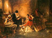 Nikolaos Gyzis, "To krifó scholió", Oil painting, 1885/86.
Despite the immense persecution of the Turks, no villager ever converted. Deep in their heart, they upheld the faith and in secret carried out their religious responsibilities. The oldest church in Metamorfosi is the church of St. Georgios in the cemetery which was built in the middle of the Byzantine era. Marble and old Roman columns were used in its construction. Nestled between the majestic cypress trees, it served as a hiding place for many throughout the years and according to some, it served as "Krifo Scholio" during the Turkish occupation. Unfortunately, the original church was torn down and rebuilt thus, losing its original Byzantine architecture and its connection to our roots.
In later years and in the middle of the present day square, the church of Panagia was built. South of the church lay the village square with a few cypress and lilac trees. Under their shadow, the village festivities unfolded especially during the Easter holiday. This church was demolished in 1922 and a new, larger one was built to accommodate the increasing population and it was dedicated to the Metamorfosis of Christ. This church was built with a dome and decorated with precious icons and hand carved wood. Many of the precious icons as well at the holy articles were donated to the church by the Roumanis and Manolakakis families from Odessa. Unfortunately, most of these items were distributed to large city centres and museums in 1967 when this church was also demolished for the construction of the new and present day one.
Places of interest
Metamorfosi has shown its own beauty. On the one hand, the beautiful valley of the village with a variety of vegetation and the other the mountain slot, which has been declared a protected area, are sources of wealth and parts suitable for walking and meditation.
Separate piece, worthy of observation is a natural sink 1,300 meters southeast of the village with the surrounding meadow and wetland in Vothana. The wetland is the interesting flora and fauna (especially birds) periodically collects and presents scientific interest.
Still, a place of natural beauty is Tsakonas stream west of the village, which is a quiet canyon, a place suitable for meditation and concentration. In the natural landscape of the region come to add their presence to their beauty many churches with the special historic and architectural interest.
Such is St. John, the chapel of St. Nicholas, St. Marina, St. Gregory, etc., are examples of deep faith of the villagers. Important in terms of delivery is the area "Pigadia" (English: Wells) in the southern boundaries of the settlement. This is an area where traditional watermills recently restored and is a picture that arouses nostalgic moments of the past for their elders and a source of teaching materials for less.
Of particular interest from an archeological point of view, presents the Cave " Trypa tou Voria" (English: Hole of North) which was discovered by the Italian Speleological Group "SPARVIERE" in the late 1990s lots of beautiful stalagmites and stalactites. The speleologists who looked at talk about a miracle of Greek nature. The rarity renders them unique for Greek standards. The scale is such that, as indicated by the experts, the village is built on a section of that cave.
Climate
The climate is Mediterranean type, characterized by the alternation of wet and cold period, with a dry and warm period. A feature of the village is the strong northerly winds affecting the village winter - summer.
Nearest Places
- Molaoi
- Sykea
- Monemvasia
- Elafonissos
- Neapoli
- Kythira
- Sparta
Notable people
- Giorgos Lafkas,(1919–1972) singer/songwriter
References
Bibliography
- Giorgos Koutsogiannopoulos, To chorio Metamorfosi, proin Katavothra, Metamorfosi 1996
- Giorgos Koutsogiannopoulos, I Monemvasia kai i endochora tis, Athens 2001
- Giorgos Koutsogiannopoulos, Monemvasiotikes diadromes stin chersoniso tou Malea, Athens 2009
External links
Categories:- Populated places in Laconia


Wikimedia Foundation. 2010.