- Myeik, Burma
-
This article is about the city. For the archipelago, see Mergui Archipelago.
 Location of Myeik
Myeik (Burmese: မြိတ်မြို့; MLCTS: mrit mrui., IPA: [mjeiʔ mjo̰] or [beiʔ mjo̰]; Mon: ဗိက်, [pòik]; also Mergui) is a city in Tanintharyi Division in Myanmar (Burma), located in the extreme south of the country on the coast of an island on the Andaman Sea. As of 2010[update] the estimated population was over 209,000.[1] The area inland from the city is a major smuggling corridor into Thailand.
Contents
History
Myeik was the southernmost part of the Pagan Empire between the 11th and 13th centuries. After the Pagan Empire's collapse in 1287, Myeik became part of successive Siamese kingdoms (first Sukhothai, and later Ayutthaya) from the late 13th century to the middle of 18th century (except between 1564 and 1593 when the Burmese temporarily regained control).
From the 16th century on, the city was an important seaport and trading center with the Europeans, who would land at Myeik (then called Mergui), travel upriver to Tanintharyi (Tenasserim) and then cross the mountains to reach Ayutthaya. The French officer Chevalier de Beauregard was made Governor of the city of Mergui after the revolt against the English there in July 1687.[2] De Beauregard was named Governor by Narai, the King of Siam, replacing an Englishman, Samuel White.[3] The French were then expelled from Mergui following the 1688 Siamese revolution.
The Burmese captured Myeik in 1765 as part of an invasion that would ultimately topple the Ayutthaya kingdom in 1767. In 1826, the Burmese ceded the region to the British after the First Anglo-Burmese War (1824-1826).
Economy
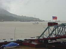 Port of Myeik
The population is engaged in fishing, production of rubber and coconuts, manufacture of fermented shrimp paste, the collection of edible bird's nests and pearl farming. Mergui is a gateway to the 800 offshore islands of the Mergui Archipelago which are developing a tourist trade. Tourism in the area is restricted to cruises as land based accommodations are currently non-existent on the islands. This keeps the area very attractive as low impact tourism preserves the area's natural beauty.[4]
Ethnicity
The inhabitants of the city are descended from many ethnic groups (Burmese, Chinese, Karen, Indian, Mon, and Moken). They speak Burmese with a distinctive accent. The island people, the Moken (Salone),[4] are famous as the "Sea Gypsies" and are said to be related to island tribes from Malaysia.
Education
The town is home to Myeik University.
See also
Notes
- ^ "Myanmar: largest cities and towns and statistics of their population:calculation 2010" World Gazetteer
- ^ Smithies, p.99
- ^ Anderson, John (1890) English intercourse with Siam in the seventeenth century K. Paul, Trench, Trübner, & Company, London, Reprinted by Routledge, London in 2000 page 365, ISBN 0-415-24548-6
- ^ a b "Mergui Archipelago" Mergui.org
See Also Speedboat
References
- ^ "Myanmar: largest cities and towns and statistics of their population:calculation 2010" World Gazetteer
- ^ Smithies, p.99
- ^ Anderson, John (1890) English intercourse with Siam in the seventeenth century K. Paul, Trench, Trübner, & Company, London, Reprinted by Routledge, London in 2000 page 365, ISBN 0-415-24548-6
- ^ a b "Mergui Archipelago" Mergui.org
- Smithies, Michael (2002) Three military accounts of the 1688 revolution in Siam Orchid Press, Bangkok, ISBN 974-524-005-2
- Pardieu, Vincent (December 2007) "South Sea Cultured Pearls From Mergui, Burma (Myanmar)" FieldGemology. org (author's webpage)
Coordinates: 12°26′N 98°36′E / 12.433°N 98.6°E
Capital: Myeik Adon • Alechaung • Anyin • Atwingyi • Awegyun • Bandane • Banmadi • Bashugyaung • Be-makyauk • Binlaing • Bok (12°41'0"N 98°46'0"E) • Bok (12°30'0"N 98°52'0"E) • Chaungnyi-ako • Dathwe • Dawe • Dechaung • Gyindaungchaung • Gyodaung • Gyon-gyon-gya • Hpayaungnekyun • Ingamaw • Kabaw • Kabin • Kabingyaung • Kadinchaung • Kahan • Kalatanyet • Kalinban • Kalwin • Kamagyaung • Kanazogalet • Kanazogon • Kanbyin • Kangalet • Kangyi (12°35'0"N 98°27'0"E) • Kangyi (12°34'0"N 98°28'0"E) • Kanmaw • Kapa • Katan • Kathayaing • Kattaluchaung • Kaungmu • Kawsaing • Kin • Kinso • Kobin • Konmaw Thagan • Kude • Kyatchaung • Kyattaungnge • Kyauk-kon • Kyaukpeik • Kyaukpya (12°31'0"N 98°42'0"E) • Kyaukpya (12°28'0"N 98°42'0"E) • Kyauk-pyu • Kyaukpyu • Kyauktaung-nge • Kyaukthinbaw • Kywegu • Leikkye • Leiktaung • Letme • Linlut • Lutlut • Lwa-zadon • Lwazin • Ma-ainggyun • Ma-e • Maingtwe • Maingtwedaung • Malagu • Mashweu • Mathe • Maunglaw • Maw-yut • Mayanbin • Mayanbinchaung • Mayanchaung (12°26'0"N 98°25'0"E) • Mayanchaung (12°0'0"N 98°50'0"E) • Mayinla (12°16'0"N 98°44'0"E) • Mayinla (12°15'0"N 98°44'0"E) • Mayinnge • Mazaw • Mazawpyingyi • Mechaung • Medaw • Milaungbyin • Mingok • Minkaungse • Minthan • Myeik • Nandawya • Nanhpon • Nat-einhmaw • Ngamangyaung-auk • Ngapeinchaung • Nyaungbi • Okpogyauk • Okpo-maw • Pabwi • Pabyin (12°41'0"N 98°48'0"E) • Pabyin (12°39'0"N 98°48'0"E) • Padauk • Palawbaw-aw • Palawgon • Palon • Panadaung • Pasut • Pataw • Pathaung • Pawutgyichaungwa • Payatwet • Payi • Pedaing • Peindaw • Peinnedaung • Peywa • Pin-o • Pyinbyu • Pyindaung • Pyingyi • Pyinnge • Pyinwun • Sakanthit • Salin • Salun • Sandange • Sandawut • Shanbon • Shannge • Shwedu • Sidaungaing • Sidongyaung • Sihposhwe • Singu (11°51'0"N 98°45'0"E) • Singu (11°48'0"N 98°44'0"E) • Singugyi • Tamok • Tamyaung • Tankyun • Tanpane • Tanyet • Tarokpa • Tarokpyin • Tasha • Tattaung • Tatwingyi • Taubye • Taungbyo • Taungkanlan • Taungnge • Taungnyo • Taungpila • Taungshe • Taungthame • Taungthaya • Taungyade • Taungyagyi (12°14'0"N 98°36'0"E) • Taungyagyi (12°1'0"N 98°44'0"E) • Tawbya • Tawbyagyi • Tawga • Tawgya • Tawnaukle • Tazin • Thagan (12°21'0"N 98°52'0"E) • Thagan (12°21'0"N 98°51'0"E) • Thalame • Thamet • Thamēyē • Tharapaing • Tharapyet • Tharawungyi • Tharawuntaungngē • Thayingan • Thebonpya • Thechaung (11°39'0"N 98°17'0"E) • Thechaung (11°38'0"N 98°30'0"E) • Thedangyi • Thinbonkyun • Thingantaw • Thitmin • Thityawa • Tibu • Tichaung • Ti-ywa • Tonbyaw • Wadawbyin • Wadawchaung • Waingdaung • Wayit • Wunbyegyi • Wunbyenge • Wunchaung • Wunpo • Yadaung • Yahugan • Yazaba • Yazabachaungbya • Yedwingyaung • Ye-e • Yegyo • Yemyitkyi (12°33'0"N 98°20'0"E) • Yemyitkyi (12°28'0"N 98°45'0"E) • Zawepyingyi • Zegami
Categories:- Populated places in Taninthayi Region
- Township capitals of Burma
- Myeik Township


Wikimedia Foundation. 2010.