- Medusae Fossae Formation
-
Medusa Fossae Coordinates 3°12′S 163°00′W / 3.2°S 163.0°WCoordinates: 3°12′S 163°00′W / 3.2°S 163.0°W Length 333.0 km The Medusae Fossae Formation is a broad geological unit of uncertain origin on the planet Mars. It is named for the Medusa of Greek mythology. "Fossae" is Latin for "trenches". Located roughly at 5°S 213°E / 5°S 213°E, it straddles the highland - lowland boundary near the Tharsis and Elysium volcanic areas.
The Medusae Fossae Formation is a soft, easily eroded deposit that extends for nearly 1,000 km along the equator of Mars. Sometimes, the formation appears as a smooth and gently undulating surface, however in places it is wind-sculpted into ridges and grooves.[1] Radar imaging has suggested that the region may contain either extremely porous rock (for example volcanic ash) or deep layers of glacier-like ice deposits amounting to about the same quantity as is stored in Mars' south polar cap.[2][3] Another evidence for a fine-grained composition is that the area gives almost no radar return. For this reason it has been called a "stealth" region.[4] The formation is divided into three subunits (members) that are all considered to be Amazonian age, the youngest era in martian geological history.[5]
-
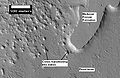
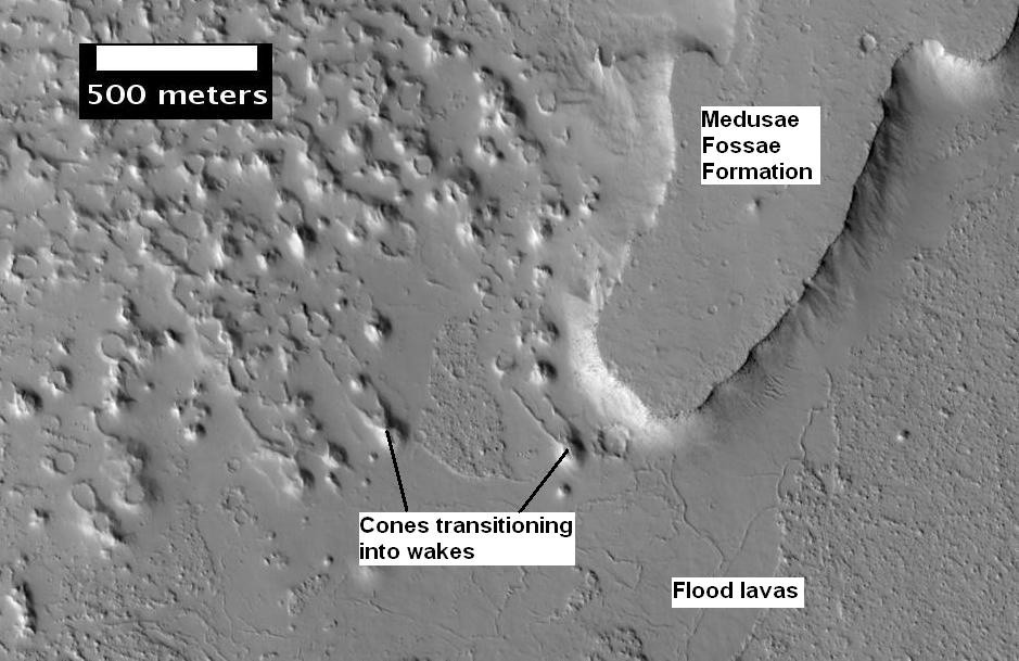
Plateau made up of Medusae Fossae materials and rootless cones, as seen by HiRISE. Rootless cones are caused by lava interacting with water ice. Wakes are caused by lava flowing over a source of steam.
-
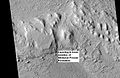
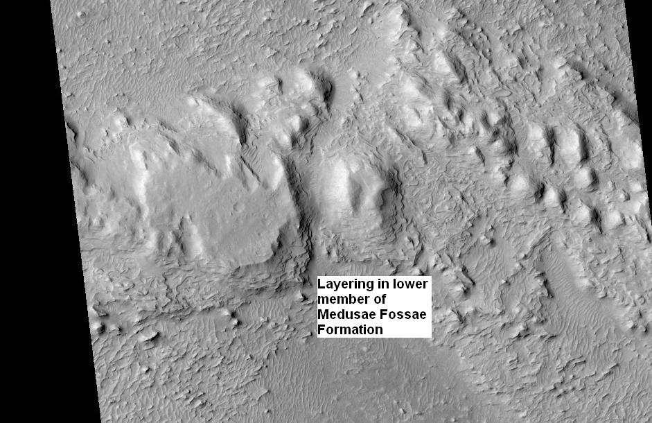
Layers in lower member of Medusae Fossae Formation, as seen by HiRISE. Location is Aeolis quadrangle.
Contents
Inverted Relief
The lower portion (member) of Medusae Fossae Formation contins many patterns and shapes that are thought to be the remains of streams. It is believed that streams formed valleys that were filled and became resistant to erosion by cementation of minerals or by the gathering of a coarse covering layer. These inverted stream beds are sometimes called sinuous ridges or raised curvilinear features. They have been divided into six classes: flat-crested, narrow-crested, round-crested, branching, non-branching, and multilevel. They may be a kilometer or so in length. Their height ranges from a meter to greater than 10 meters, while the width of the narrow ones is less than 10 meters.[6][7]
-
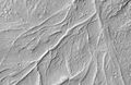
Sinuous Ridges within a branching fan in lower member of Medusae Fossae Formation, as seen by HiRISE. Location is Aeolis quadrangle.
Yardangs
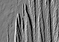
The surface of the formation has been eroded by the wind into a series of linear ridges called yardangs. These ridges generally point in direction of the prevailing winds that carved them, and demonstrate the erosive power of martian winds. The easily eroded nature of the Medusae Fossae Formation suggests that it is composed of weakly cemented particles, and was most likely formed by the deposition of wind-blown dust or volcanic ash. Layers are seen in parts of the formation. A resistant caprock on the top of yardangs has been observed in Viking,[8] Mars Global Surveyor,[9] and HiRISE photos.[10] Images from spacecraft show that they have different degrees of hardness probably because of significant variations in the physical properties, composition, particle size, and/or cementation. Very few impact craters are visible throughout the area so the surface is relatively young.[11]
-
Medusae Fossae Formation as seen with Mars Odyssey's THEMIS. Notice elongated formations called yardangs.
-
Medusae Fossae Formation as seen with HiRISE. Image is located in the Aeolis quadrangle.
-

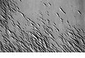
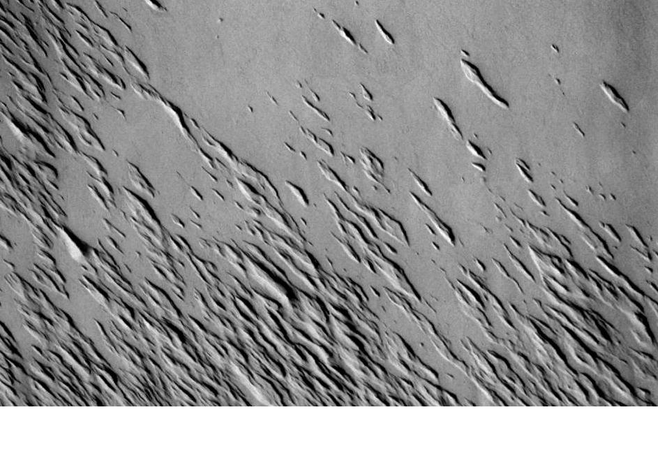
Yardangs in the Medusae Fossae formation, as seen by HiRISE under HiWish program. Location is the Amazonis quadrangle.
-
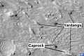
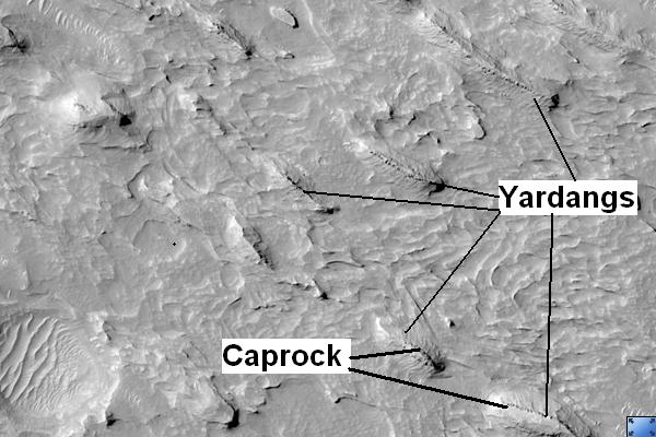
Yardangs in Medusae Fossae Formation with caprock labeled, as seen by HiRISE. Location is Aeolis quadrangle.
References
- ^ http://www.universetoday.com/2005/03/29/medusa-fossae-region-on-mars/
- ^ Shiga, David (1 November 2007). "Vast amount of water ice may lie on Martian equator". New Scientist Space. http://space.newscientist.com/article/dn12866-vast-amount-of-water-ice-may-lie-on-martian-equator.html. Retrieved 20 January 2011.
- ^ Watters, T. R.; Campbell, B.; Carter, L.; Leuschen, C. J.; Plaut, J. J.; Picardi, G.; Orosei, R.; Safaeinili, A. et al. (2007). "Radar Sounding of the Medusae Fossae Formation Mars: Equatorial Ice or Dry, Low-Density Deposits?". Science 318 (5853): 1125. Bibcode 2007Sci...318.1125W. doi:10.1126/science.1148112. PMID 17975034.
- ^ Barlow, Nadine G. (2008). Mars: an introduction to its interior, surface and atmosphere. Cambridge, UK: Cambridge University Press. pp. 75-76. ISBN 978-0-521-85226-5.
- ^ Scott, D.; Tanaka, K. (1986). "Geologic map of the western equatorial region of Mars" (PDF). U.S. Geol. Survey Misc. Invest Series Map 1:15,000,000. http://astrogeology.usgs.gov/Projects/PlanetaryMapping/DIGGEOL/mars/marswest/mw.pdf.
- ^ Zimbelman, James R.; Griffin, Lora J. (2010). "HiRISE images of yardangs and sinuous ridges in the lower member of the Medusae Fossae Formation, Mars". Icarus 205: 198–210. Bibcode 2010Icar..205..198Z. doi:10.1016/j.icarus.2009.04.003.
- ^ www.sciencedirect.com/science/journal/00191035
- ^ Scott, David H.; Tanaka, Kenneth L. (1982). "Ignimbrites of Amazonis Planitia Region of Mars". Journal of Geophysical Research 87: 1179–1190. Bibcode 1982JGR....87.1179S. doi:10.1029/JB087iB02p01179.
- ^ Malin, MC; Carr, MH; Danielson, GE; Davies, ME; Hartmann, WK; Ingersoll, AP; James, PB; Masursky, H et al. (March 1998). "Early views of the martian surface from the Mars Orbiter Camera of Mars Global Surveyor". Science 279 (5357): 1681–5. Bibcode 1998Sci...279.1681M. doi:10.1126/science.279.5357.1681. PMID 9497280.
- ^ Mandt, Kathleen E.; De Silva, Shanaka L.; Zimbelman, James R.; Crown, David A. (2008). "The origin of the Medusae Fossae Formation, Mars: Insights from a synoptic approach". Journal of Geophysical Research 113. Bibcode 2008JGRE..11312011M. doi:10.1029/2008JE003076. http://hdl.handle.net/10088/7052.
- ^ http://themis.asu.edu/zoom-20020416a
See also
- Amazonis Planitia
- Inverted relief
- Geology of Mars
- Impact crater
- Yardang
External links
Categories:- Memnonia quadrangle
- Surface features of Mars
- Amazonis quadrangle
- Valleys and canyons on Mars
-


Wikimedia Foundation. 2010.