- South Pole Traverse
-
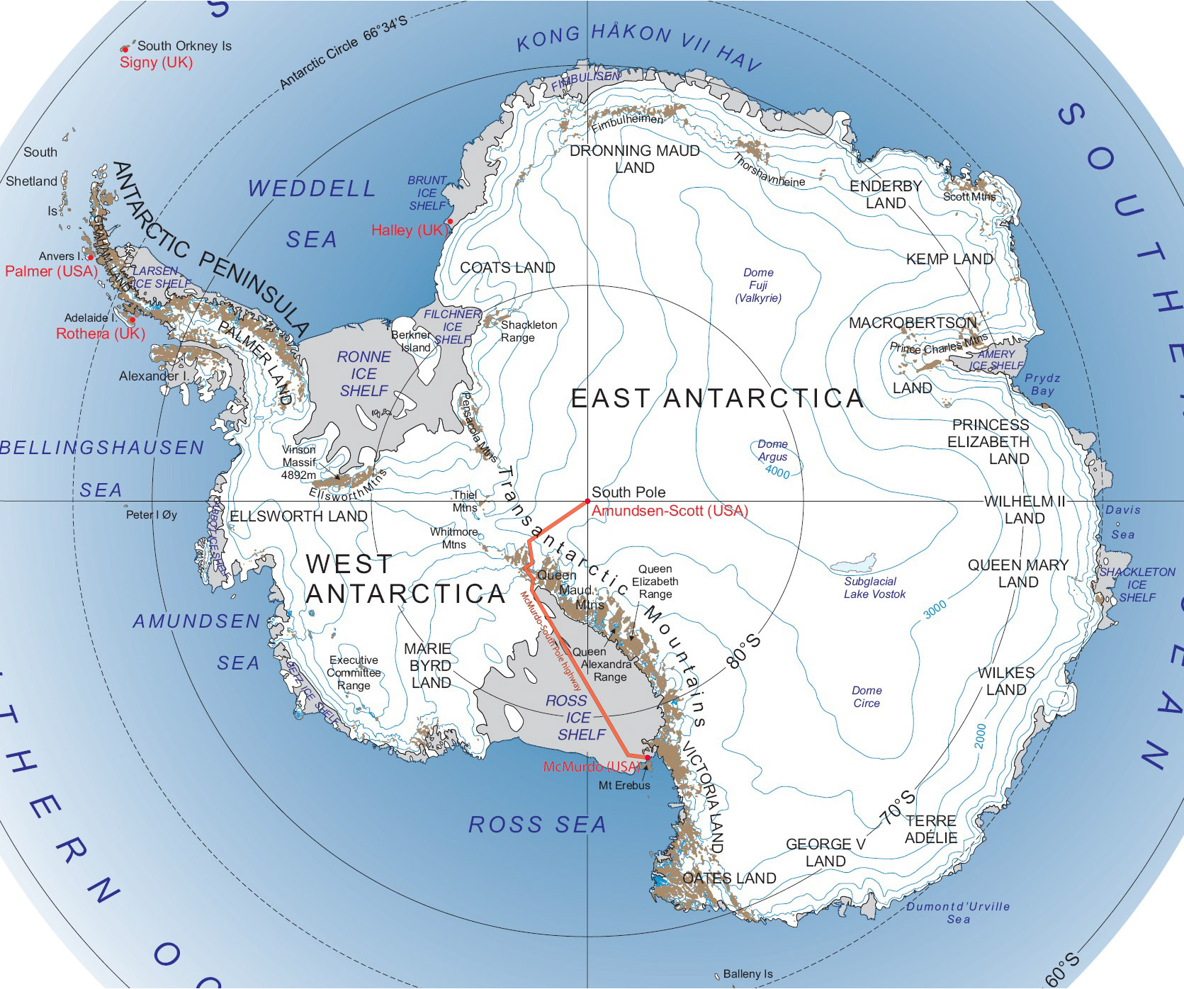
South Pole Traverse McMurdo – South Pole Highway 
A red line indicating the path of the traverseRoute information Length: 900 mi[citation needed] (1,400 km) Existed: 2007 – present Major junctions South end: Amundsen–Scott South Pole Station North end: McMurdo Station Highway system The South Pole Traverse, also called the McMurdo – South Pole Highway, is an approximately 900-mile (1450 km) compacted snow road in Antarctica that links the United States' McMurdo Station on the coast to the Amundsen–Scott South Pole Station. It was constructed by leveling snow and filling in crevasses, but is not paved; flags mark its route.
Contents
Route description
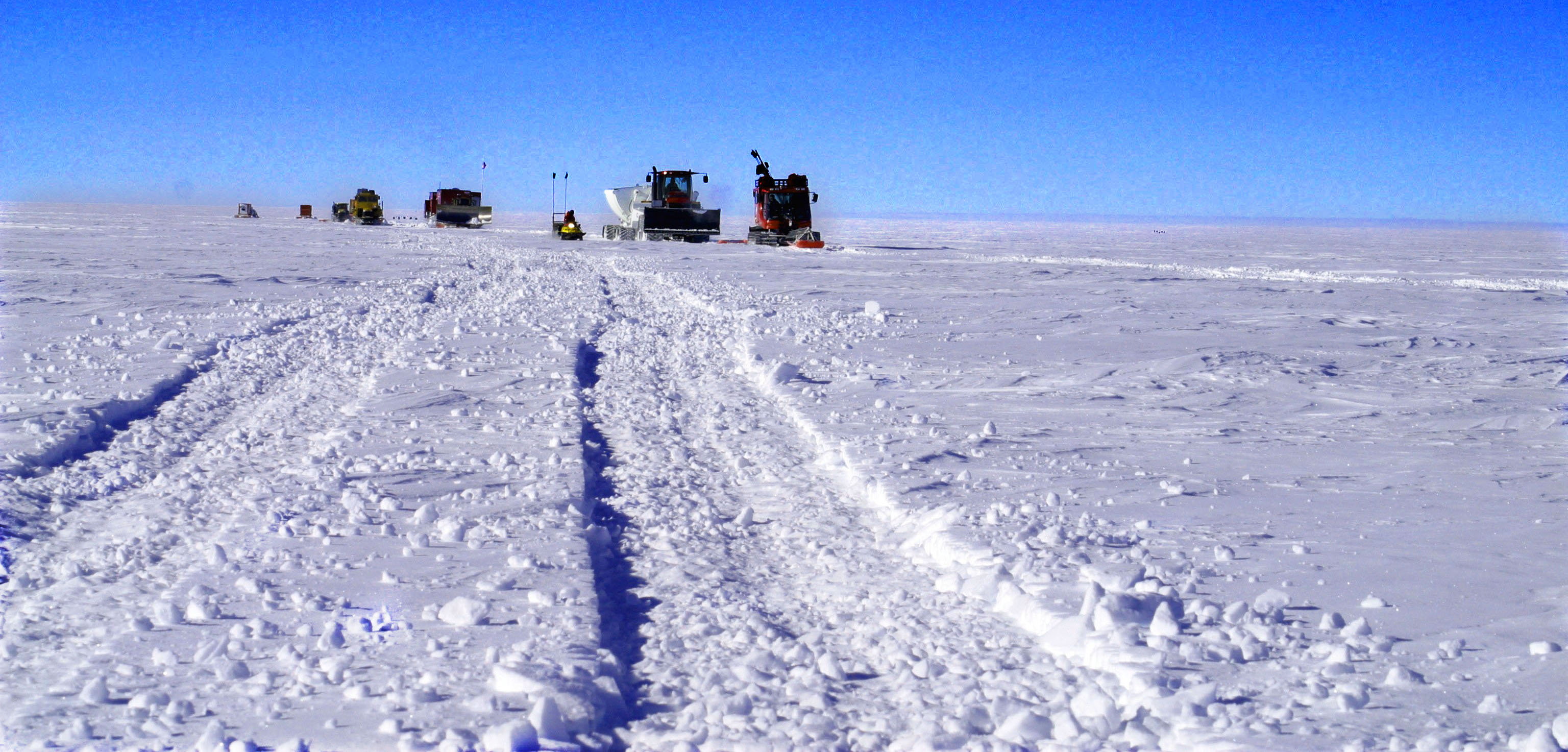
After four years of development, the trail is now operational, with Caterpillar and Case Corp. tractors pulling specialized sleds to deliver fuel and cargo to the South Pole in about 40 days. The return trip to McMurdo Station, with less fuel and cargo, is substantially shorter. Construction started during the 2002-03 southern summer field season. It was finished in the southern summer of 2005-2006.[1]
The McMurdo Ice Shelf and the Antarctic Plateau are relatively stable. Most crevasses occur in the short steep shear zone between them, where the road climbs to more than 2000 meters above sea level. This section of the road needs maintenance each season. The section caused much more construction work than planned, since two ice sheets move against each other there.[citation needed]
History
 Cargo caravan on the ice highway early 2006
The project was funded by the United States National Science Foundation to provide a lower cost, potentially more reliable method of supplying the South Pole Station. Bad weather at McMurdo some summers has reduced the total number of supply flights the NSF could make to bring in construction supplies and scientific equipment. In addition, the traverse saves an estimated 40 flights and lowers the carbon footprint over the use of aircraft[citation needed]. After a one-year hiatus, a traverse team re-occupied the trail during the 2007–08 season after extensive work and completed the first operational traverse in 2008–09.[2]
The road also facilitated the movement of heavy equipment needed to implement its proposed South Pole Connectivity Program, a planned optical fiber link between the South Pole and the French–Italian Concordia Station located at Dome C at the edge of the Antarctic Plateau; Concordia has 24-hour access to geosynchronous satellites. Such satellites cannot be used at the poles since they are below the horizon; the South Pole now uses a few older, low-bandwidth satellites that dip sufficiently south of the equator to be usable for several hours daily. These satellites are near the end of their life. A new road to McMurdo might provide a regularly maintained alternate route for such a link; however, opinions vary as to the shear zone section's suitability for a long-term cable. It's also possible the NSF may choose to deploy several special purpose satellites in polar orbits.[3]
A February 7, 2006 NSF press release stated that 110 tons (99,790 kg) of cargo had been successfully delivered overland to the South Pole Station in a "proof of concept" of the highway.[4]
Major intersections
Region Location Mile Destinations Notes East Antarctica Antarctic Plateau 0 Amundsen–Scott South Pole Station Southern terminus West Antarctica Ross Ice Shelf 900 McMurdo Station Northern terminus 1.000 mi = 1.609 km; 1.000 km = 0.621 mi References
- ^ "The Antarctic Sun, Jan. 1, 2006". The Antarctic Sun. http://antarcticsun.usap.gov/pastIssues/2005-2006/2006_01_01.pdf.
- ^ "Ready to roll". The Antarctic Sun. 2009-05-01. http://antarcticsun.usap.gov/features/contentHandler.cfm?id=1361.
- ^ "South Pole online in 2009". ITworld. December 24, 2002. http://www.itworld.com/Tech/4535/021224southpoleonline/.
- ^ "Icy Overland Trip May Add Ground Vehicles to South Pole Supply Missions" (Press release). National Science Foundation. February 7, 2006. http://www.nsf.gov/news/news_summ.jsp?cntn_id=105718. Retrieved March 31, 2011.
Further reading
- USA's Science-Driven "Ice Highway" Hitting Rough Sledding in Antarctica Online Insider, December 13, 2004
- No, not a ski resort - it's the south pole Guardian (UK), January 24, 2003
- "Construction Begins on South Pole Highway". Outside Online. January 30, 2003. http://outside.away.com/news/headlines/20030130_1.html.
- "US building highway to the South Pole". New Scientist. January 23, 2003. http://www.newscientist.com/article.ns?id=dn3300.
- NSF FY 2007 Budget Request to Congress -- see pages 197 to 203 for a discussion of the proposed highway
- NSF 2005 Facility Plan -- see page 53 for a brief overview of fiber vs. satellite links
- Diagram of route with timeline of progress made to date
- Tractor caravan supplies South Pole scientists; robotic replacements considered Washington Post, February 8, 2011
- Robotic Traverse
External links
 Media related to South Pole Highway at Wikimedia Commons
Categories:- Transport in Antarctica
- United States and the Antarctic
- 2007 in Antarctica
- McMurdo Station
Wikimedia Foundation. 2010.