- Maynas Province, Peru
-
Maynas — Province — [[File: 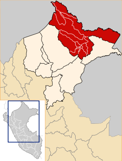 |250px|none|alt=|Location of Maynas in the Loreto Region]]Location of Maynas in the Loreto Region
Country Peru Region Loreto Founded Capital Iquitos Government - Mayor Salomon Abensur Diaz Area - Total 119,859.4 km2 (46,278 sq mi) Elevation 106 m (348 ft) Population - Total 536,423 UBIGEO 1601 Website www.munimaynas.gob.pe Maynas is a province in the Loreto Region in northeastern Peru. Its capital, Iquitos, is also Loreto's regional capital and the largest city in the Peruvian Amazon Rainforest.
Contents
Boundaries
The Maynas Province is bordered by Ecuador on the northwest, Colombia on the north, northeast and east, the Mariscal Ramón Castilla and Requena provinces on the south, and the Loreto Province on the southwest.
Demographics
Population
According to the 1993 Census, the Maynas Province has a population of 393,496 inhabitants, 50.6% of which (199,209) are male and 49.4% (194,287) are female.
As of 2005, the Instituto Nacional de Estadística e Informática esimates the province's population to be 536,423.
Languages
The majority of the province's residents (96%) speak Spanish at home; other languages spoken are Quechua (2%), Aymara (150 speakers, 0.0%), other indigenous languages (0.8%) and foreign languages (0.2%).
Immigration
Persons originating from other regions of the country make up 8.4% of the population and 0.3% of residents were born abroad.
The largest immigrant groups are from the San Martín Region (2.9% of the total population), the Lima Province/Lima Region (1.8%), and Ucayali Region (1.3%).
Age
The population is spread out with
- 54.1% under the age of 20,
- 8.9% from 20 to 24,
- 24.6% from 25 to 44,
- 9.5% from 45 to 64, and
- 3% who are 65 years of age or older.
Education
Secondary education has been attended by 28.8% of the population and 2.5% also have graduated from non-university higher education, while 2.6% have complete university studies. 46.7% only have attended primary education and 8.5% have not had any education.
The illiteracy rate in the province is 13.1%.
Political division
The province is divided into thirteen districts (Spanish: distritos, singular: distrito), each of which is headed by a mayor (alcalde). The districts, with their capitals in parenthesis, are:
Districts
- Alto Nanay (Santa María de Nanay)
- Belén (Belén)
- Fernando Lores (Tamshiyacu)
- Indiana (Indiana)
- Iquitos (Iquitos)
- Las Amazonas (Francisco de Orellana)
- Mazán (Mazán)
- Napo (Santa Clotilde)
- Punchana (Punchana)
- Putumayo (Puca Urco officially; El Estrecho de facto)
- San Juan Bautista (San Juan Bautista)
- Teniente Manuel Clavero
- Torres Causana (Pantoja)
Places of interest
- Allpahuayo-Mishana National Reserve
External links
- (Spanish) Municipalidad Provincial de Maynas - Maynas provincial municipality
 Provinces of Loreto Region | Peru
Categories:- Provinces of the Loreto Region
- Provinces of Peru

Wikimedia Foundation. 2010.