- Cataracts of the Nile
-
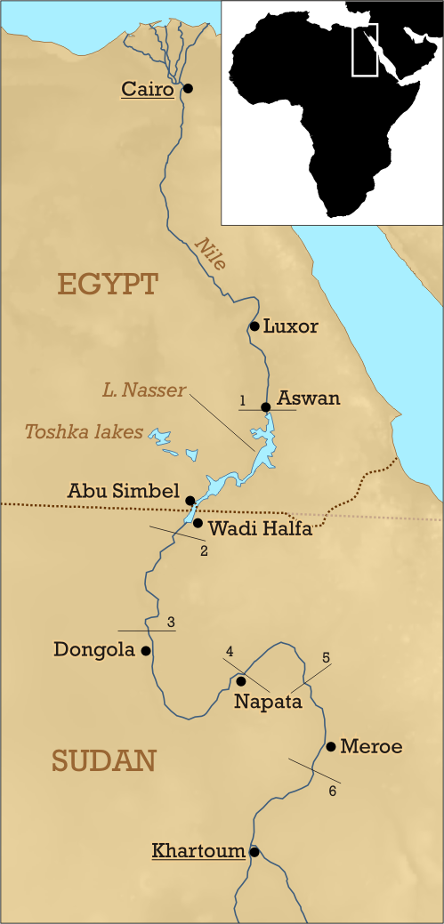
 The six cataracts of the Nile
 Fourth Cataract
 Sixth Cataract
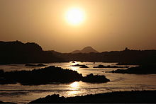
The cataracts of the Nile are shallow lengths (or white water rapids) of the Nile between Aswan and Khartoum where the surface of the water is broken by many small boulders and stones protruding out of the river bed, as well as many rocky islets. Aswan is also the Southern boundary of Upper Egypt. In some places, these stretches are punctuated by whitewater and are perhaps well characterized as rapids, while at others the water flow is smoother, but still shallow. Counted going upstream (from north to south), the First Cataract is in modern Egypt; the rest are in Sudan.
- The First Cataract cuts through Aswan (24°04′41″N 32°52′41″E / 24.078°N 32.878°E) This is also the only cataract that is in modern-day Egypt; the rest are now in Sudan.
- The Second Cataract (or Great Cataract) was in Nubia and is now submerged under Lake Nasser (21°29′N 30°58′E / 21.48°N 30.97°E)
- The Third Cataract is around Tombos/Hannek (19°46′N 30°22′E / 19.76°N 30.37°E)
- The Fourth Cataract is in the Manasir Desert and is flooded by the Merowe Dam beginning in the third quarter of 2008 (18°55′N 32°22′E / 18.91°N 32.36°E)
- The Fifth Cataract is near the confluence of the Nile and Atbarah Rivers (17°40′37″N 33°58′12″E / 17.677°N 33.970°E)
- The Sixth Cataract is where the Nile cuts through the Sabaluka pluton, close to Bagrawiyah (16°17′17″N 32°40′16″E / 16.288°N 32.671°E)
Characteristics
The word cataract is a Greek word literally "down-rushing", meaning "rapids", "floodgate" or "waterfall". However, none of the Nile's six primary cataracts could be accurately described as waterfalls, and given a broader definition, this is the same with many of the minor cataracts. Geologists indicate that the region of the northern Sudan is tectonically active and this activity has caused the river to take on "youthful" characteristics.[1] The Nubian Swell has diverted the river's course to the west, while keeping its depth shallow and causing the formation of the cataracts. Even as the river bed is worn down by erosion, the land mass is lifted, keeping parts of the river bed exposed. These distinctive features of the river between Aswan and Khartoum have led to the stretch being often referred to as the Cataract Nile, while the downstream portion is occasionally referred to as the "Egyptian" Nile. The geological distinction between these two portions of the river is considerable. North of Aswan, the river bed is not rocky, but is instead composed of sediment, and far from being a shallow river, it is believed[by whom?] that the bedrock was previously eroded to be several thousand feet deep. This created a vast canyon that is now filled by the sediment, some of which originated from the Mediterranean. For more information, see the Eonile as well as the Messinian salinity crisis.
Despite these characteristics, some of the cataracts which are normally impassable by boat become navigable during the flood season.
The six primary cataracts of the Nile are described extensively by European colonials, notably by Winston Churchill in The River War (1899), where he recounts the exploits of the British trying to return to Sudan between 1896 and 1898, after they were forced to leave in 1885.
In ancient times, Upper Egypt extended from south of the Nile Delta to the first cataract, while further upstream, the land was controlled by the ancient Kush civilization, that would later take over Egypt.[2]
Notes
- ^ Thurmond, A.K., et al. (2004). The Nubian Swell, The Journal of African Earth Sciences 39 pp. 401-407. [1] (accessed 21 October 2006)
- ^ "Cataracts of the Nile". Fummo.com. http://www.fummo.com/info/Cataracts_of_the_Nile.html. Retrieved 16 July 2011.
External links
- The Cataract Nile and the Great Bend (webpage) [2]
- The 1905-1907 Breasted Expeditions to Egypt and the Sudan: A Photographic Study [3] (See photos listed in the index under "Nile, Third Cataract" and "Nile, Fourth Cataract")
- Photo links
Categories:- Landforms of Egypt
- Landforms of Sudan
- Nile


![[4]](http://www.cromwell-intl.com/travel/egypt/pictures/egypt-0037.jpg)
![[5]](http://www.travelhistory.org/people+places/ModernNile/ModernNile-05pic1.jpg)
Wikimedia Foundation. 2010.