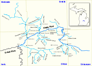
Maple River (Grand River)

Maple River (Grand River)
Maple River
River
Country USA
State Michigan
Counties Clinton, Ionia, Gratiot, Shiawassee
Cities Ovid, Elsie, Maple Rapids, Muir
Source
 - location Shiawassee Township, Shiawassee County, Michigan, USA
 - coordinates 42°56′42″N 84°6′53″W / 42.945°N 84.11472°W / 42.945; -84.11472
Mouth Grand River
 - location Muir, Michigan, USA
 - coordinates 42°59′45″N 84°57′18″W / 42.99583°N 84.955°W / 42.99583; -84.955
Length 74 mi (119 km)
Basin 944 sq mi (2,445 km2)

The Maple River is a 74.1-mile-long (119.3 km)[1] tributary of the Grand River in the central part of the Lower Peninsula of the U.S. state of Michigan. It rises in Shiawassee Township, Shiawassee County south of the city of Owosso. It flows west through Clinton, Gratiot and Ionia counties, flowing into the Grand River at Muir. Other cities it flows through along the way include Ovid, Elsie and Maple Rapids.[2]

There are 5 major dams along the river and its tributaries: Lake Victoria, Lake Ovid, Elsie, Rainbow and Hubbardston.[2]

References

  1. ^ U.S. Geological Survey. National Hydrography Dataset high-resolution flowline data. The National Map, accessed May 19, 2011
  2. ^ a b Maple River History Friends of the Maple River

External links


Wikimedia Foundation. 2010.

Игры ⚽ Нужно сделать НИР?

Look at other dictionaries:

  • Maple River (Michigan) — The Maple River is the name of three rivers in the U.S. state of Michigan: Maple River (Burt Lake), rises in Pleasant View Township, Emmet County, and flows into Burt Lake in Cheboygan County[1] Maple River (Grand River), rises in Shiawassee… …   Wikipedia

  • Grand River (Michigan) — Grand River Lage des Grand River in MichiganVorlage:Infobox Fluss/KARTE fehlt DatenVorlage:In …   Deutsch Wikipedia

  • Maple Rapids, Michigan —   Village   …   Wikipedia

  • Grand River (Michigan) — Infobox River river name = Grand River image size = 250px caption = A map of the Grand River origin = Somerset Township, Hillsdale County, Michigan mouth = Grand Haven, Michigan basin countries = length = 260 miles elevation = mouth elevation =… …   Wikipedia

  • Maple Leaf (train) — Maple Leaf The Maple Leaf crosses the Whirlpool Rapids Bridge, in 1983. Overview Service type International Inter city rail …   Wikipedia

  • Grand Trunk Western Railroad — 1887 map of GTW predecessor railroads Reporting mark GTW Locale Michiga …   Wikipedia

  • Maple Grove, Minnesota —   City   Maple Grove Government Center …   Wikipedia

  • Maple Green, New Brunswick — Maple Green   Unincorporated community   …   Wikipedia

  • Maple Lawn — U.S. National Register of Historic Places …   Wikipedia

  • Maple Bay, Minnesota — Maple Bay is an unincorporated community in Godfrey Township,in central Polk County, Minnesota, United States. A community of second homes and cabins, it lies on the west end of Maple Lake, approximately 6 miles west of Erskine. Maple Bay is… …   Wikipedia

Share the article and excerpts

Direct link
Do a right-click on the link above
and select “Copy Link”