- Maniitsoq ice sheet
-
 Maniitsoq ice sheetLocation within Greenland
Maniitsoq ice sheet (old spelling: Manîtsoq, Danish: Sukkertoppen iskappe) is a 58 × 41 km (36 × 25 mi) ice sheet in the Qeqqata municipality in western Greenland.
Geography
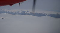 Aerial view of the icesheet in poor visibility.
There are no settlements in the vicinity of the ice sheet. In the southeast, Maniitsoq ice sheet is separated from the westward tongue of the Greenland ice sheet (Kalaallisut: Sermersuaq) by the narrow Kangerlussuatsiaup Qingua valley.
In the south, several mountain glaciers drain it towards the upper reaches of the Kangerlussuatsiaq Fjord. To the west, the ice sheet is drained by the long Sermitsiaq Glacier. To the northwest, numerous mountain glaciers drain it towards Kangerlussuaq Fjord.[1] To the northeast of the icesheet lies the wide highland of Angujaartorfiup Nunaa, home to herds of muskoxen,[2] originally reintroduced in its northern part from the populations of the Northeast Greenland National Park.[3]
Coordinates: 66°13′N 52°11′W / 66.217°N 52.183°W
References
- ^ Maniitsoq, Saga Map, Tage Schjøtt, 1992
- ^ "Moskusokser ved Kangerlussuaq tælles" (in Danish). Kalaallit Nunaata Radioa. 12 February 2010. http://www.knr.gl/index.php?id=183&tx_ttnews%5Btt_news%5D=53193&cHash=358cb81ead. Retrieved 18 May 2010.
- ^ O'Carroll, Etain (2005). Greenland and the Arctic. Lonely Planet. pp. 166. ISBN 1-74059-095-3.
Categories:- Glaciers of Greenland


Wikimedia Foundation. 2010.