- Nunatakassak
-

 Nunatakassak (Upernavik Archipelago)
Nunatakassak (old spelling: Nunatakavsak) is a nunatak (Kalaallisut: nunataq) in the Qaasuitsup municipality in northwestern Greenland. It is one of several nunataks in the Melville Bay region of Greenland, where the Greenland ice sheet (Kalaallisut: Sermersuaq) drains into the bay alongside its entire length apart from an occasional nunatak.[1][2]
Geography
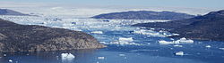 Aerial view of Nunatakassak and the Ikerasaa strait between the Kullorsuaq and Saqqarlersuaq islands.
Nunatakassak is located on the mainland of Greenland in the northernmost part of Upernavik Archipelago. To the south, Greenland icesheet drains into Melville Bay via Nunatakassaup Sermia glacier separating it from Wandel Land, another nunatak.[1] To the northwest lies the Nunatarsuaq nunatak, possibly isolated as a new island, with OpenStreetMap maps, and the satellite photographs of Google Maps showing the nunatak as already isolated, with fast sea-ice in place of the retreated icesheet.[3]
Coordinates: 74°40′N 56°37′W / 74.667°N 56.617°W
References
- ^ a b Upernavik Avannarleq, Saga Map, Tage Schjøtt, 1992
- ^ Qimmsseriarsuaq, Saga Map, Tage Schjøtt, 1992
- ^ Google. Google Maps (Map). http://maps.google.com/maps?f=q&source=s_q&hl=en&geocode=&q=74%C2%B043%E2%80%B200%E2%80%B3N+56%C2%B058%E2%80%B200%E2%80%B3W&sll=74.716667,-56.983333&sspn=0.151493,0.891953&ie=UTF8&ll=74.709528,-56.751938&spn=0.151561,0.891953&t=h&z=11.
Upernavik Archipelago, Greenland Bays Fjords Eqalugaarsuit • Kangerluarsuk • Kangerlussuaq (Kangeq Peninsula) • Kangerlussuaq Icefjord • Nasaussap Saqqaa • Nuussuup Kangia • Saqqarsuaq • Sullua • Tasersuatsiaq • Upernavik IcefjordGlaciers Alanngorsuup Sermia • Cornell • Giesecke • Hayes • Illullip Sermia • Kjer • Nunatakassaup Sermia • Nunatakassaup Sermia (Tasiusaq Bay) • UpernavikHeadlands Islands Melville BayInussulik BayIkermiut • Illoorfik • Inussullissuaq • KiatassuaqSugar Loaf BayAmitsorsuaq • Ikermiorsuaq • Itissaalik • Kittorsaq • Nasaussaq • Qullikorsuit • Sugar Loaf • TimilersuaTasiusaq BayAappilattoq • Anarusuk • Apparsuit • Ateqanngitsorsuaq • Aukarnersuaq • Horse Head • Illunnguit • Innaarsuit • Kangaarsuk • Maniitsoq • Mattaangassut • Mernoq • Naajaat • Nuuluk • Nutaarmiut • Paagussat • Paornivik • Puugutaa • Qaarsorsuatsiaq • Qallunaat • Qaneq • Qaqaarissorsuaq • Qullikorsuit • Saattorsuaq • Sisuarissut • Tasiusaq • Tussaaq • Tuttorqortooq • UigorlersuaqBaffin BayAappilattoq • Akia • Akuliaruseq • Amarortalik • Ammaussarsuaq • Atilissuaq • Iperaq • Karrat • Kingittorsuaq • Nako • Nunaa • Nutaarmiut • Qaarsorsuaq • Qasse • Qeqertaq • Qeqertarsuaq • Saattoq • Sanningassoq • Singarnaq-Annertussoq • Taartoq • Tukingassoq • Uilortussoq • UpernavikMountains/Nunataqs Akullikassaq • Anoritooq • Devil's Thumb • Inalugartuut • Inngik • Iviannernat • Kangerluarsuup Qaqqarsua • Kingittoq • Kissavaussaq • Kunngutip Qaqqaa • Naajannguaq • Naalungiussaq • Najaarsuit Qaqqat • Niaqornarsuaq • Nunatakassak • Nunatarsuaq • Nunatarsuaq (Tasiusaq Bay) • Nuniaat Qaqqarsua • Orsugissap Qaqqarsua • Paatuup Qaqqaa • Qaqqasunnarsuaq • Qassersuit • Saattup Akia • Sandersons Hope • Sisuarsuit • Toornaarsuttoq • Tunullersuaq • Tuttulikassak • Umiasussuk • Wandel LandPeninsulas Straits Akornat • Ammarqua • Appaalissiorfiup Ikerasaa • Ikerasaa • Ikerasak • Ikerasakassak • Ikerasassuaq • Qassersuit Saqqaa • Saqqarlersuup Sullua • Simiuttap Ikerasaa • TorsukattakTowns/Settlements Aappilattoq • Kangersuatsiaq • Kullorsuaq • Innaarsuit • Naajaat • Nutaarmiut • Nuussuaq • Tasiusaq • Upernavik • Upernavik KujalleqCategories:- Melville Bay
- Nunataks of Greenland
- Upernavik Archipelago

Wikimedia Foundation. 2010.