- Mernoq Island
-
Mernoq 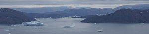
Aerial view of Mernoq Island (right)
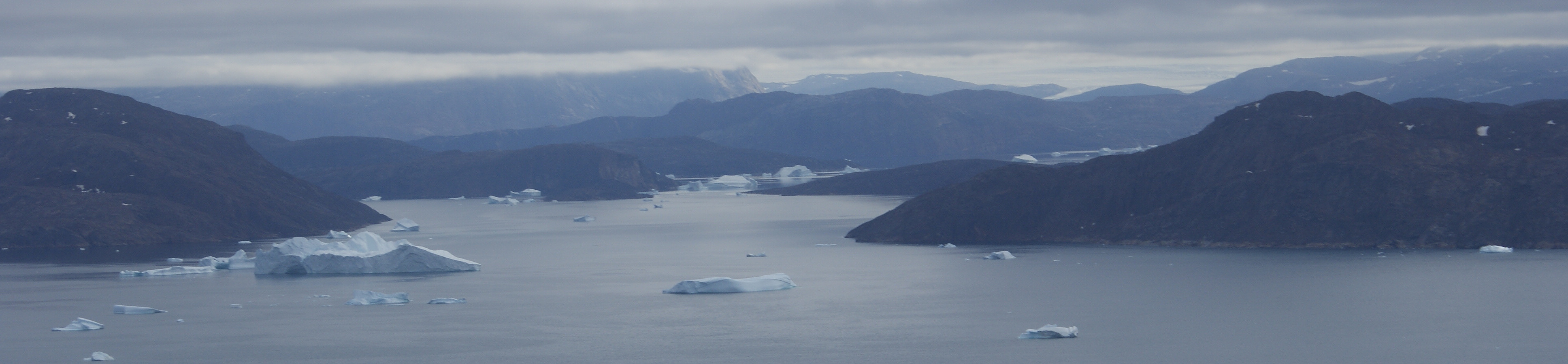
 Mernoq Island (Upernavik Archipelago)
Geography Location Greenland Coordinates 73°44′50″N 56°17′00″W / 73.74722°N 56.2833333°WCoordinates: 73°44′50″N 56°17′00″W / 73.74722°N 56.2833333°W Archipelago Upernavik Archipelago Length 9.7 km (6.03 mi) Country GreenlandMunicipality Qaasuitsup Mernoq Island is an uninhabited island in the Qaasuitsup municipality in northwestern Greenland.
Contents
History
With brief intervals of no permanent settlement, Mernoq Island was inhabited between 1891, when the Kuuk settlement was founded, and 1972, when it was abandoned.[1] Kuuk was perched on the southern end of the island, at the Qernertunnguaq cape.[2]
Geography
Mernoq Island is located in Tasiusaq Bay, in the north-central part of Upernavik Archipelago. It is sandwiched between Qullikorsuit Island in the north − from which it is separated by the Mernup Tunua strait − Paornivik Island in the northeast, and Tuttorqortooq Island in the southwest.[2]
The island is hilly, but not mountainous; the highest point is an unnamed hill of 386 m (1,266 ft) in the center of the island.[2]
Coastline
The coastline of the island is generally undeveloped, with two shallow, unnamed bays in the east.[2]
Promontories
Name Direction Latitude N Longitude W Mernup Erqua Northwestern Cape 73°46′20″ 56°24′50″ Nannuffik Eastern Cape 73°43′13″ 56°09′50″ Qernertunnguaq Southern Cape 73°42′20″ 56°11′40″ References
Upernavik Archipelago, Greenland Bays Fjords Eqalugaarsuit • Kangerluarsuk • Kangerlussuaq (Kangeq Peninsula) • Kangerlussuaq Icefjord • Nasaussap Saqqaa • Nuussuup Kangia • Saqqarsuaq • Sullua • Tasersuatsiaq • Upernavik IcefjordGlaciers Alanngorsuup Sermia • Cornell • Giesecke • Hayes • Illullip Sermia • Kjer • Nunatakassaup Sermia • Nunatakassaup Sermia (Tasiusaq Bay) • UpernavikHeadlands Cape Shackleton • Nuussuup Nuua • Wilcox HeadIslands Melville BayKiatassuaq • Kiataussaq • Kullorsuaq • Saarlia • SaqqarlersuaqInussulik BayIkermiut • Illoorfik • Inussullissuaq • KiatassuaqSugar Loaf BayAmitsorsuaq • Ikermiorsuaq • Itissaalik • Kittorsaq • Nasaussaq • Qullikorsuit • Sugar Loaf • TimilersuaTasiusaq BayAappilattoq • Anarusuk • Apparsuit • Ateqanngitsorsuaq • Aukarnersuaq • Horse Head • Illunnguit • Innaarsuit • Kangaarsuk • Maniitsoq • Mattaangassut • Mernoq • Naajaat • Nuuluk • Nutaarmiut • Paagussat • Paornivik • Puugutaa • Qaarsorsuatsiaq • Qallunaat • Qaneq • Qaqaarissorsuaq • Qullikorsuit • Saattorsuaq • Sisuarissut • Tasiusaq • Tussaaq • Tuttorqortooq • UigorlersuaqBaffin BayAappilattoq • Akia • Akuliaruseq • Amarortalik • Ammaussarsuaq • Atilissuaq • Iperaq • Karrat • Kingittorsuaq • Nako • Nunaa • Nutaarmiut • Qaarsorsuaq • Qasse • Qeqertaq • Qeqertarsuaq • Saattoq • Sanningassoq • Singarnaq-Annertussoq • Taartoq • Tukingassoq • Uilortussoq • UpernavikMountains/Nunataqs Akullikassaq • Anoritooq • Devil's Thumb • Inalugartuut • Inngik • Iviannernat • Kangerluarsuup Qaqqarsua • Kingittoq • Kissavaussaq • Kunngutip Qaqqaa • Naajannguaq • Naalungiussaq • Najaarsuit Qaqqat • Niaqornarsuaq • Nunatakassak • Nunatarsuaq • Nunatarsuaq (Tasiusaq Bay) • Nuniaat Qaqqarsua • Orsugissap Qaqqarsua • Paatuup Qaqqaa • Qaqqasunnarsuaq • Qassersuit • Saattup Akia • Sandersons Hope • Sisuarsuit • Toornaarsuttoq • Tunullersuaq • Tuttulikassak • Umiasussuk • Wandel LandPeninsulas Straits Akornat • Ammarqua • Appaalissiorfiup Ikerasaa • Ikerasaa • Ikerasak • Ikerasakassak • Ikerasassuaq • Qassersuit Saqqaa • Saqqarlersuup Sullua • Simiuttap Ikerasaa • TorsukattakTowns/Settlements Aappilattoq • Kangersuatsiaq • Kullorsuaq • Innaarsuit • Naajaat • Nutaarmiut • Nuussuaq • Tasiusaq • Upernavik • Upernavik KujalleqCategories:- Uninhabited islands of Greenland
- Tasiusaq Bay
- Upernavik Archipelago
Wikimedia Foundation. 2010.