- Duhring, West Virginia
-
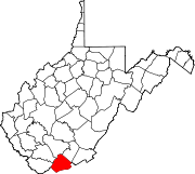
Duhring, West Virginia — Unincorporated community — Location within the state of West Virginia Coordinates: 37°20′51″N 81°15′49″W / 37.3475°N 81.26361°WCoordinates: 37°20′51″N 81°15′49″W / 37.3475°N 81.26361°W Country United States State West Virginia County Mercer Elevation 2,260 ft (689 m) Time zone Eastern (EST) (UTC-5) – Summer (DST) EDT (UTC-4) Area code(s) 304 & 681 GNIS feature ID 1538416[1] Duhring is an unincorporated community in Mercer County, West Virginia, United States. Duhring is 1 mile (1.6 km) southwest of Montcalm.
References
Municipalities and communities of Mercer County, West Virginia Cities Towns CDPs Other
communitiesAda | Arista | Beeson | Black‡ | Bluestone | Brush Fork | Camp Creek | Cashers Hill | Ceres | Chestnut Knob | Coaldale | Crystal | Dott | Duhring | Dunns | Eads Mill | Edison | Egeria‡ | Elgood | Flat Top | Flipping | Gardner | Gardner Junction | Giatto | Glenwood | Godfrey | Goodwill | Green Valley | Hardy | Hatcher | Hiawatha | Ingleside | Johnston Town | Kale | Kegley | Kellysville | Lake Shawnee | Lamar‡ | Lerona | Lilly Grove | Littlesburg | Lorton Lick | Lovern | Maple Acre | Maple View | McComas | Melrose | Micajah | Midway | Mount Olive | Nemours | New Hope | Oak Grove | Piedmont | Pinoak | Rock | Sandlick | Spanishburg | Speedway | Wolfe | Yards‡
Footnotes ‡This populated place also has portions in an adjacent county or counties
Categories:- Populated places in Mercer County, West Virginia
- Unincorporated communities in West Virginia
- New River Greenbrier geography stubs
Wikimedia Foundation. 2010.


