- Drumanagh
-
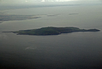 The island of Lambay is just off the County Dublin coast close to Drumanagh. Some remains (Roman brooches and decorative metalware) were discovered on the island, which are thought to date to the 1st century AD. The nature of artefacts found there also demonstrated Romano-British trading.
Drumanagh (Irish Droim Meánach)[1] is a headland 20 km north of Dublin, Ireland. It features a 19th century Martello tower and a large (200,000 m²) iron age promontory fort which has produced Roman artefacts.
Some archaeologists have suggested the fort was a bridgehead for Roman military campaigns, while others suggest it was a Roman trading colony or a native Irish settlement that traded with Roman Britain.[2][3]
Contents
Characteristics
Drumanagh is nearly 900 m. long and 190 m. wide. The area consists of a small peninsula defended by three rows of parallel ditches on the landward side. It is surrounded on three sides by the Irish sea, showing huge erosion that could have reduced its size to the present 44 acres (180,000 m2) and may have destroyed evidences of old Roman structures.
The site is privately owned and is a Recorded Monument, protected under the Section 12 of the National Monuments (Amendment) Act, l994, and by a Preservation Order placed on it in 1977. Although its archaeological importance has been known since the 1950s, when ploughing turned up sherds of Roman samian ware, it has not been subject to archaeological excavation, but numerous artefacts have been dug up by illegal metal detectorists. One such collector attempted to sell a trove of Roman coins and ornaments at Sotheby's in London in the 1980s, which was impounded and deposited in the National Museum of Ireland. Since then, a legal dispute over ownership has prevented the artefacts and their provenance from being discussed publicly.[4][3][5]
History
 Tacitus wrote that the roman general Agricola in 82 crossed the sea (of Ireland?) from western Britain and conquered "tribes unknown" to Romans
Barry Raftery[6] and Gabriel Cooney[7] have suggested that the fort may have been used by Gnaeus Julius Agricola, then Roman governor of Britain, for an invasion of Ireland in AD 82. The Roman historian Tacitus mentions that Agricola entertained an exiled Irish prince, thinking to use him as a pretext for a possible conquest of Ireland. Agricola, says Tacitus, "crossed in the first ship" and defeated peoples unknown to the Romans until then. He does not specify which body of water he crossed, although many scholars believe it was the Clyde or Forth; however, the rest of the chapter exclusively concerns Ireland.[8]
Agricola fortified the coast facing Ireland, and Tacitus recalls that his father-in-law often claimed the island could be conquered with a single legion and auxiliaries.[9] This conquest never happened, but some historians believe that the crossing referred to was in fact a military expedition to Ireland.[10]
Vittorio De Martino [10] argues that there was continuous interaction between Roman Britain and Ireland. Richard Warner suggests that Drumanagh may have been the bridgehead for an invasion of exiled Irish and British adventurers, who, with Roman support, carved out kingdoms for exiled Irish noblemen, and links this with the legend of Tuathal Techtmar, who is said to have been exiled to Britain in the 1st or 2nd century, and returned with an army to seize the kingship.[11] A group of burials on Lambay Island, just off the coast near Drumanagh, contained Roman brooches and decorative metalware of a style also found in Roman Britain from the late first century. Indeed, some archeological discoveries inside Ireland, like Roman jewelry and coins at Tara and Clogher, support the possibility of a Roman invasion of Ireland.[12]
Notes
- ^ Placenames Database of Ireland, retrieved 22 June 2009
- ^ Richard Warner, "Yes, the Romans did invade Ireland", British Archaeology 14, May 1996, retrieved 14 August 2009
- ^ a b Shawn Pogatchnik, "Experts Claim Romans May Have Established Colonies in Ireland", Los Angeles Times, 17 November 1996, retrieved 22 July 2009
- ^ John M. Byrne, "Drumanagh Promontory Fort", Archaeology News & Views website, 2003, retrieved 22 July 2009>
- ^ "In Brief", British Archaeology 12, March 1996, retrieved 22 July 2009
- ^ Barry Raftery, Pagan Celtic Ireland, Thames & Hudson Ltd, London, 1997
- ^ Gabriel Cooney, "Ireland, the Romans and all that", Archaeology Ireland, Spring 1996
- ^ Tacitus, Agricola 24
- ^ Tacitus Agricola 24
- ^ a b Vittorio di Martino (2003), Roman Ireland, The Collins Press, London, 2003
- ^ "Roman Ireland: What did the Romans ever do for us?", Blather.net, 27 July 2002, retrieved 14 August 2009
- ^ R. B. Warner (1995), "Tuathal Techtmar: a myth or ancient literary evidence for a Roman invasion?", Emania 13, pp. 23-32
Coordinates: 53°32′N 6°05′W / 53.54°N 6.08°W
Bibliography
- Cooney, Gabriel. Ireland, the Romans and all that from Archaeology Ireland, Spring 1996.
- Di Martino, Vittorio. Roman Ireland, The Collins Press. London, 2003.
- Raftery, Barry. Pagan Celtic Ireland. Thames & Hudson Ltd. London, 1997.
See also
- Hibernia
- Hibernia and Roman Empire
- History of Ireland
- Roman Empire
- Tuathal Techtmar
External links
Categories:- Roman Britain
- Ancient Ireland
- Geography of Fingal


Wikimedia Foundation. 2010.