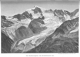
- Dreiherrnspitze
-
Dreiherrnspitze 
Elevation 3,499 m (11,480 ft) Location Location Salzburg, Tyrol, both Austria, and South Tyrol, Italy Range Hohe Tauern Coordinates 47°4′12″N 12°14′22″E / 47.07°N 12.23944°ECoordinates: 47°4′12″N 12°14′22″E / 47.07°N 12.23944°E Climbing First ascent 2 November 1866 by Balthasar Ploner, M. Dorer and I. Feldner The Dreiherrnspitze (Italian: Picco dei Tre Signori; German: Dreiherrnspitze) is a mountain on the border between Salzburg, Tyrol, both Austria, and South Tyrol, Italy.
References
- Willi End: Alpenvereinsführer Venedigergruppe, München 2006, ISBN 3-7633-1242-0
- Eduard Richter, Hrsg.: Erschließung der Ostalpen, III. Band, Verlag des Deutschen und Oesterreichischen Alpenvereins, Berlin 1894
- Alpenvereinskarte 1:25.000, Sheet 36, Venedigergruppe
External links
 Media related to Dreiherrnspitze at Wikimedia CommonsCategories:
- Mountains of the Alps
- Mountains of Salzburg
- Mountains of Tyrol
- Mountains of South Tyrol
- Alpine Three-thousanders
- Austria–Italy border
- International mountains of Europe
- Venediger Group
Wikimedia Foundation. 2010.
