Draycott in the Moors

Draycott in the Moors

Coordinates: 52°57′25″N 2°01′34″W / 52.957°N 2.026°W / 52.957; -2.026

Draycott in the Moors
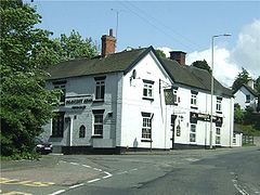
Draycott Arms.jpg
The Draycott Arms is on the corner of Uttoxeter Road and Cheadle Road
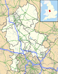
Draycott in the Moors is located in Staffordshire
Draycott in the Moors

 Draycott in the Moors shown within Staffordshire
Population 221 
Shire county Staffordshire
Region West Midlands
Country England
Sovereign state United Kingdom
Postcode district ST8 6xx
Police Staffordshire
Fire Staffordshire
Ambulance West Midlands
EU Parliament West Midlands
List of places: UK • England • Staffordshire

Draycott-in-the-Moors is a village between Newcastle-under-Lyme and Uttoxeter near the River Blythe. It is two and a half miles from Cheadle and is near Blythe Bridge railway station, on the North Staffordshire Railway.[1]

In 1851 the parish contained 518 inhabitants. Sir Edward Vavasour, Bart., was the lord of the manor.

Contents

Notable residents

  • The recusant Draycot family lived in the parish. Anthony Draycot, priest, died here in 1571.
  • Joseph Reeves, a shepherd of this parish, who claimed to have lived to 127 years old. He said he had never taken tobacco or physic, nor drank between meals, alleviating his thirst by rolling pebbles in his mouth."[1]

References

  1. ^ a b History, Gazetteer and Directory of Staffordshire, William White, Sheffield, 1851, accessed at Genuki, 28 February 2009

See also

External links

Media related to Draycott in the Moors at Wikimedia Commons


Wikimedia Foundation. 2010.

Игры ⚽ Поможем решить контрольную работу

Look at other dictionaries:

  • Draycott — may refer to: Draycott, Derbyshire Draycott and Breaston railway station (closed) Draycott, Gloucestershire Draycot, Oxfordshire Draycott, in Rodney Stoke parish, Somerset Draycott Sleights, a nearby SSSI Draycott railway station (closed)… …   Wikipedia

  • The Long Lane — est le nom médiéval et moderne de la voie romaine qui coupait presque plein ouest à travers le Derbyshire, depuis Derventio, camp fortifié et vicus romain situé dans la banlieue de la Derby moderne (dont le musée présente des éléments de ce… …   Wikipédia en Français

  • The Long Lane — (долгая дорога)  средневековое и современное название римской дороги, которая лежит к западу от Дервентио, римской крепости и викуса в окрестностях современного Дерби, и проходит через Дербишир к Рочестеру (где было римское поселение) в… …   Википедия

  • Draycott Sleights — Site of Special Scientific Interest …   Wikipedia

  • Curry and Hay Moors — Site of Special Scientific Interest Curry Moor Pumping Station …   Wikipedia

  • List of civil parishes in Staffordshire — This is a list of civil parishes in Staffordshire, England. Stoke on Trent is included in this list (though it is entirely unparished). =Cannock Chase= Cannock is unparished.* Brereton and Ravenhill * Bridgtown * Brindley Heath * Cannock Wood *… …   Wikipedia

  • Cresswell, Staffordshire — This article is about the village near Stoke on Trent. For the village near Stafford, see Creswell, Staffordshire. Coordinates: 52°57′05″N 2°02′15″W / 52.951434°N 2.0 …   Wikipedia

  • Blythe Bridge — infobox UK place country = England official name= Blythe Bridge longitude= 2.0709 latitude= 52.9704 population = 1,478 shire county= Staffordshire shire district= Staffordshire Moorlands civil parish= Blythe Bridge and Forsbrook region= West… …   Wikipedia

  • Somerset Levels — The Somerset Levels (or Somerset Levels and Moors as they are less commonly, but more correctly, called) is a sparsely populated wetland area of central Somerset, England, between the Quantock and Mendip hills. They consist of marine clay levels… …   Wikipedia

  • Cheadle Branch Line — Legend …   Wikipedia

Share the article and excerpts

Direct link
Do a right-click on the link above
and select “Copy Link”