- Regional Connector (Los Angeles Metro)
-
 Regional Connector
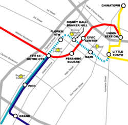
Metro rail map of downtown Los Angeles with possible routing of Regional Connector (in dashed blue line)Overview Type light-rail (LRT) System Los Angeles County Metro Rail Status in environmental review Locale Los Angeles Termini 7th St/Metro Center
Little Tokyo/Arts DistrictOperation Opened TBD Operator(s) Los Angeles County Metropolitan Transportation Authority (Metro) The Regional Connector (formally, the Metro Regional Connector Transit Corridor Project, also known as the Downtown Connector or Downtown Light-Rail Connector) is a proposed mass-transit rail project to create a new light-rail corridor through Downtown Los Angeles. The purpose of the corridor is to connect the Blue and Expo Lines to the Gold Line and Union Station. The corridor would become part of the Los Angeles County Metro Rail System.
The project is being planned by the Los Angeles County Metropolitan Transportation Authority (Metro). The project has been given high priority by Metro in its long-range plan[1] and has funding set aside in Measure R.[2]
The Draft Environmental Impact Report (DEIR) was completed in September 2010 and selection of a preferred alternative was completed in late October 2010. Metro staff is now working to complete preliminary engineering and a Final Environmental Impact Report (FEIR), and expects to complete the FEIR in Summer 2011. Metro hopes to complete construction and begin revenue service by 2018 or 2020.[3]
Contents
Background
The connector was envisioned as far back as 1984 when planning and building the Metro Blue Line and restudied with a through connection in the Pasadena Light Rail Corridor studies in 1990. LACMTA envisioned the Blue Line running through Downtown to Union Station and onward to Pasadena with potential future lines (Burbank/Glendale to the northwest and Exposition Park/Santa Monica to the south and west). The connector was not completed due to lack of funds and realignment of the Red Line Eastside Extension which later became an extension of the Pasadena Gold Line.
The connector was formally studied for the first time as a standalone project in a Major Investment Study in 1992–1993, in preparation of its Long Range Transportation Plan. The project was again revived in 2004, when LACMTA staff initiated a technical feasibility assessment for a potential regional connector. This study focused on conceptual methods to provide a regional connector and to alleviate potential operational constraints [1].
The 2004 staff study looked at the potential alignments of the Downtown Connector that could not be done entirely underground due to funding constraints from the voter-approved 1998 Prop A ban on local county subway funding. Most of the alignments involved an alignment under Flower Street, surfacing somewhere between 5th Street and 1st Street and then proceeding east to Alameda Street. From here, these alignments would connect to the Eastside light rail corridor (now part of the Metro Gold Line), and continue either north toward Union Station and Pasadena or east toward East Los Angeles. Most alignments had conceptual stations at the following locations:
-
- Central Library
- Bunker Hill
- Los Angeles City Hall
- Little Tokyo
LACMTA staff analyzed a number of at-grade, street-running couplets, transit mall, elevated and hybrid subway/at-grade/elevated alignments along various east-west streets such as Temple Street, First Street, Second Street and Third Street and utilizing available grade-separated infrastructure such as the Second Street Tunnel through Bunker Hill (between Hill and Figueroa Streets) or the Third Street Tunnel (between Hill and Flower Streets) to minimize costs, improve operating times and improve the feasibility of constructing the project.
In July 2006, the LACMTA Board voted to approve funding and staff to initiate a Major Investment Study (MIS) for the Regional Connector in conjunction with approval of a similar study for the extension of the Red Line subway. In June 2007, the LACMTA Board approved the consultants to perform the Alternative Analysis and MIS and in November 2007, preliminary outreach meetings for the Alternative Analysis were held at Central Library and the Japanese American National Museum (JANM). The results from these meetings were presented to the public in February 2008, including the descriptions of the eight route alternatives identified for analysis. These eight "build" alternatives were narrowed down to two in 2008. At the January 2009 Metro Board Meeting, the Regional Connector was approved and received funding to continue in the environmental study process.
Environmental review process
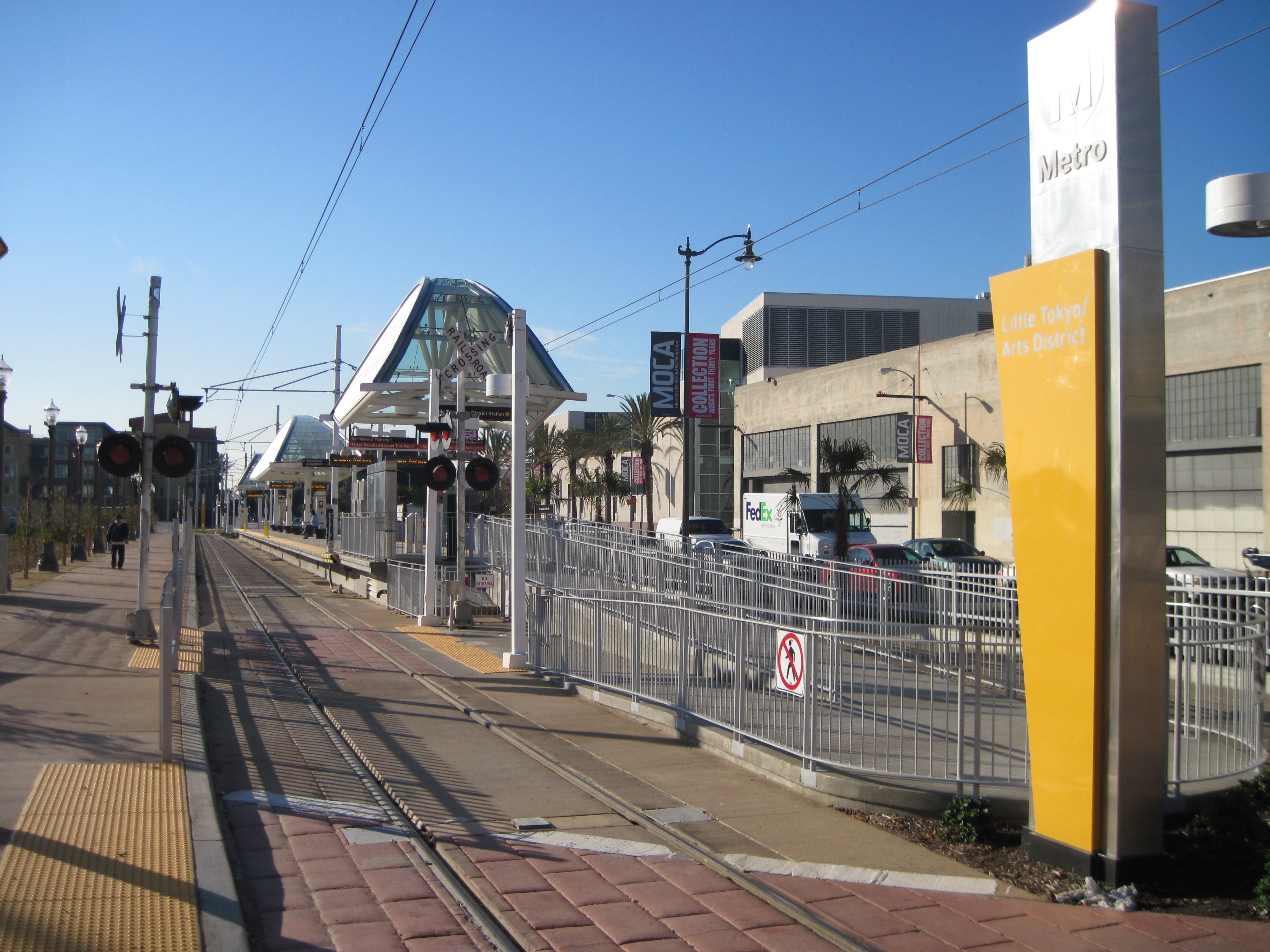
 If the underground alignment is chosen, the current Little Tokyo station may be moved underground and diagonally across Alameda and 1st Street.
The Alternatives Analysis yielded two LRT (light rail) build alternatives,[4] plus the required "No Build" and "TSM" (Transportation System Management) options. A third LRT build alternative was added in February 2010, at the request of Little Tokyo stakeholders (including property, business, and homeowners).
The operational intent of the project is to allow through running of service between the four corridors (Blue Line corridor, Expo corridor, Gold Pasadena corridor, and Gold Eastside corridor). All three build alternatives begin at the 7th St/Metro Center station, which is currently the northern terminus of the Blue Line and future terminus of the Expo Line (currently under construction). And all three build alternatives connect to the current Gold Line at Alameda Street near Temple Street or 1st Street.
On October 28, 2010, the LACMTA Board of Directors rejected At-Grade and underground emphasis alternatives, and opted for a fully underground option. This route remains underground below Flower and 2nd Streets until northwest of 1st/Alameda. By that point, the route would have split into two branches. Each branch would then emerge from a tunnel - one heading north to Union Station, and the second heading east to the Eastside.
Metro added this alignment in February 2010, after receiving public input on the other two options. This option puts the connector underground beneath 1st/Alameda. The fourth new station (at 1st/Alameda southwest block) would replace the existing Little Tokyo/Arts District station. The third station (nearest the Civic Center) was shifted slightly west toward Broadway, in order to take advantage of redevelopment efforts in the historic core. This option is generally fastest and has fewest impacts during operations, but it would have more construction impacts and higher costs as well.
Comparison of alternatives
The following table summarizes key characteristics of each alternative:[5][6]
LRT 1 LRT 2 LRT 3 Alternative Name At-Grade Emphasis Underground Emphasis Fully Underground Cost (2009 dollars) $899 million $1,120 million $1,245 million New daily systemwide trips 12,300 14,900 17,400 Cost effectiveness [Note 1] $20.44 (medium) $17.22 (medium) $16.77 (medium-high) Travel time Union Station to Pico 14 minutes 12 minutes 10 minutes Pico/Aliso to Pico 15 minutes 10 minutes 11 minutes Station locations Financial District s of Flower/5th (below-grade) n of Flower/5th (below-grade) n of Flower/5th (below-grade) Bunker Hill sw of 2nd/Hope (below-grade) sw of 2nd/Hope (below-grade) sw of 2nd/Hope (below-grade) Broadway n of 1st/Main (sb)(at-grade)
and
n of 1st/Los Angeles (nb)(at-grade)e of 2nd/Broadway (below-grade)
or
e of 2nd/Spring (below-grade)e of 2nd/Broadway (below-grade) Little Tokyo already exists (at-grade) already exists (at-grade) ne of 2nd/Central (below-grade) - ^ FTA cost-effectiveness index (CEI) vs. the TSM alternative.
Selected alternative
In September 2010, Metro published the Draft Environmental Impact Statement/Environmental Impact Report (Draft EIS/EIR). The report recommends adoption of the "Fully Underground LRT Alternative" (LRT 3 above).[7]
In October 2010, Metro staff reaffirmed this recommendation, but with the 5th/Flower station removed. The report cites concerns for the overall project cost.[8]
At the Metro Board meeting in late October 2010, the Board certified the Draft EIS/EIR and accepted the staff recommendation (Fully Underground Alternative with the 5th/Flower station deleted) as the Locally Preferred Alternative (LPA). The project staff will now conduct a final study of the LPA, which will culminate in a Final Environmental Impact Study/Environmental Impact Report (Final EIS/EIR).
Project funding
Measure R guarantees the Regional Connector $160 million for implementation of the project.[2] The remaining funds required will have to be raised from other local, state and/or federal sources.
Planned service
The purpose of the Regional Connector is to allow rail transit service to run through Downtown Los Angeles. This implies fundamental changes to the Metro Rail lines themselves. Metro has suggested that two lines would replace the current Blue, Expo and Gold Lines. One of these would be an east-west line, running along the Expo and Eastside corridors. The other would be a north-south line, running along the current Blue and Pasadena/Foothill corridors.
Early maps show the east-west line in Gold, and the north-south line in Blue. However, Metro has not yet announced how the lines would be renamed. Metro may retain the color-naming system and name the two new lines "Blue" and "Gold": or, they may decide to go with a different naming system (e.g., letters, numbers, or destinations).
No announcement has been made regarding fare increases, if any are to be made. Currently, a new fare must be purchased every time a passenger transfers from one line to another. The Regional Connector will reduce the number of transfers and therefore reduce income. However, that loss of revenue that may be offset with increased ridership.
References
- ^ Metro (LACMTA). "Long Range Transportation Plan". http://www.metro.net/projects_studies/images/final-2009-LRTP.pdf. Retrieved 2010-08-30.
- ^ a b Metro (LACMTA). "Measure R". http://www.metro.net/projects/measurer/. Retrieved 2010-08-30.
- ^ Metro (LACMTA). "Regional Connector Transit Corridor (project website)". http://www.metro.net/projects/connector/. Retrieved 2010-08-20.
- ^ http://blogdowntown.com/2008/05/3297-regional-connector-down-to-two-alternatives
- ^ http://www.metro.net/projects_studies/connector/images/deis-deir/Executive-Summary.pdf
- ^ http://www.metro.net/projects_studies/connector/images/deis-deir/Chapter-2.pdf
- ^ http://www.metro.net/projects/connector/draft-eis-eir-report/
- ^ http://www.metro.net/board/Items/2010/10_october/20101020P&PItem5.pdf
- Los Angeles County Metropolitan Transportation Authority [2]
- City of Los Angeles Office of the Mayor [3]
Los Angeles County Metropolitan Transportation AuthorityMetro services Metro Bus
Major facilities Capital projects Expo Line (Phase 1 · Phase 2) • Foothill Extension • Crenshaw Line • Westside Subway Extension • Regional ConnectorOther information Bus fleet • Rail fleet • Transit Access Pass (TAP) • Transportation in Los AngelesCategories:- Los Angeles County Metro Rail projects
- Proposed public transportation in the United States
-

Wikimedia Foundation. 2010.