- Dervenochoria
-
Dervenochoria
ΔερβενοχώριαLocation 
 Dervenochoria
Coordinates 38°13′N 23°30′E / 38.217°N 23.5°ECoordinates: 38°13′N 23°30′E / 38.217°N 23.5°E Location within the regional unit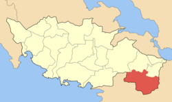
Government Country: Greece Region: Central Greece Regional unit: Boeotia Municipality: Tanagra Population statistics (as of 2001) Municipal unit - Population: 2,191 - Area: 228.9 km2 (88 sq mi) - Density: 10 /km2 (25 /sq mi) Other Time zone: EET/EEST (UTC+2/3) Elevation (center): 566 m (1,857 ft) Postal: 190 12, 320 05 Telephone: 26940 Auto: ΒΙ Dervenochoria (Greek: Δερβενοχώρια) is a former municipality in Boeotia, Greece. Since the 2011 local government reform it is part of the municipality Tanagra, of which it is a municipal unit.[1] Its 2001 population was 2,191. Its area is 228.9 km², and it covers the southernmost portion of Boeotia. The main village is Pyli.
Contents
Subdivisions
The municipal unit Dervenochoria is subdivided into the following communities (constituent villages in brackets):
Geography
Its geography consists of grasslands and bushes to the south and west, forest in the midlands and to the east that connects with Parnitha. Since the fire, many of them are burnt.
History
The municipality was created in 1997.
Most of Dervenochoria was hit by a devastating wildfire (see 2007 Greek forest fires) on Thursday June 28, 2007 that came from Parnitha westward. Some damages to property including houses and buildings were reported. The aftermath was that much of the forest turned into an ashy landscape that may take years to restore its natural beauty.
References
- ^ Kallikratis law Greece Ministry of Interior (Greek)
External links
Municipal unit of Dervenochoria Municipal unit of Oinofyta Municipal unit of Schimatari Municipal unit of Tanagra Categories:- Populated places in Boeotia
- Dervenochori


Wikimedia Foundation. 2010.