Delamere Way

Delamere Way
Delamere Way
Delamere Way Waymarker.JPG
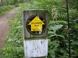
The Delamere Way Waymarker
Length 21 miles (34 km)
Location Cheshire, England
Trailheads Frodsham
Stockton Heath
Use Hiking
Season All year

The Delamere Way is a footpath running from Frodsham to Stockton Heath within the English county of Cheshire. The total length of the trail is 21 miles (34 km).[1]

The route

The Delamere Way starts at the Bridgewater Canal bridge on the A49 road (known locally as London Road), opposite the London Bridge public house. The path then proceeds to the village of Hatton passing through the nearby Walton Hall Golf Club. The path crosses the M56 motorway and Whitley Brook as it navigates farmland towards the locks on the River Weaver at Dutton. The route then closely follows the railway to Acton Bridge and continues to Onston, Ruloe and Norley before entering Delamere Forest. The path meanders through the majority of the forest, passing Blake Mere lake, and briefly follows part of the Sandstone Trail which it then intersects further on. Upon leaving the forest the path continues on its way to Frodsham via Manley and Frodsham golf course, once again joining the Sandstone Trail close to the Bellemonte public house. The path finishes on Church Street, close to St Laurence's Church, Frodsham. The route is shown on Ordnance Survey Explorer Maps 267 and 276.

References

  1. ^ The Delamere Way - The Mid-Cheshire Footpath Society

External links


Wikimedia Foundation. 2010.

Игры ⚽ Нужно сделать НИР?

Look at other dictionaries:

  • Delamere Forest — Deciduous woodland at Delamere Forest in autumn Delamere Forest or Delamere Forest Park is a wood in the Cheshire West and Chester area of Cheshire, England, near the town of Frodsham. It includes 972 hectares (2,400 acres) of mixed deciduous …   Wikipedia

  • Delamere railway station — Delamere Location Place …   Wikipedia

  • Baker Way — The Baker Way is a footpath running from Chester railway station to Delamere railway station within the English county of Cheshire. The total length of the trail is 13 miles (19 km).The route leaves Chester and passes Christleton and Brown Heath… …   Wikipedia

  • Recreational walks in Cheshire — There are 1,864 milescite web | title=Public Rights of Way| work=Cheshire County Council | url=http://www.cheshire.gov.uk/countryside/Walking/index.htm | accessdate=2007 01 27] (3,000 km) of public rights of way in Cheshire, England.The following …   Wikipedia

  • Mid Cheshire Ridge — Peckforton ridge, with Beeston (left) and Peckforton (right) castles. The Beeston Gap is on the far left The Mid Cheshire Ridge is a range of low sandstone hills which stretch north to south through Cheshire in North West England. The ridge is… …   Wikipedia

  • Cuddington, Eddisbury — Coordinates: 53°14′24″N 2°36′01″W / 53.240°N 2.600297°W / 53.240; 2.600297 …   Wikipedia

  • A556 road — Looking west at Heyesmere towards Chester …   Wikipedia

  • Moto Hospitality — Type Private Industry Hospitality Predecessor Granada Founded Toddington (7 February 2001 ( …   Wikipedia

  • List of churches preserved by the Churches Conservation Trust in Southwest England — Whitcombe Church …   Wikipedia

  • John Douglas (architect) — For other people of the same name, see John Douglas (disambiguation). John Douglas John Douglas, photograph published in 1890 Born 11 April 1830(1830 04 11) Sandiway …   Wikipedia

Share the article and excerpts

Direct link
Do a right-click on the link above
and select “Copy Link”