De Cartier (Charleroi Pre-metro station)
- De Cartier (Charleroi Pre-metro station)
-
De Cartier is a Charleroi Pre-metro station, located in the center of Marchienne-au-Pont (part of the Charleroi municipality), in fare zone 2. It is an underground station featuring a central platform with escalator and stairs access at both ends.
The interior of the station, designed by architect Noterman, features a large mural depicting Marchienne-au-Pont somewhere between the 16th and 18th century. Reproductions of old, tilted walls are used as decoration on the opposite side of the station.
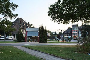
Nearby points of interest
- De Cartier castle (French: Château de Cartier), which has given its name to the station.
- Municipal park of Marchienne-au-Pont.
- Marchienne-au-Pont public swimming pool.
- Marchienne-au-Pont city hall.
- Schools : Notre-Dame and Athénée Royal Yvonne Vieslet.
- Our Lady of Mercy church.
- Marchienne-au-Pont soccer stadium.
Transfers
TEC Charleroi bus lines 43, 71, 72, 73, 74, 75, 83, 109a, 172.
Internal links
| v · Charleroi Metro lines and stations |
|
| Line 54 |
Sud • Villette • Ouest • Beaux- Arts • Waterloo • Samaritaine • Gazomètre • Gilly
|
|
| Line 55 |
Parc • Janson • Waterloo • Samaritaine • Gazomètre • Gilly
|
|
| Line 84 |
Pétria • Fontaine • Paradis • Leernes • Morgnies • Moulin • De Cartier • Providence • Dampremy • Piges • Beaux- Arts • Waterloo • Samaritaine • Gazomètre • Gilly
|
|
| Line 88 |
Parc • Janson • Waterloo • Beaux- Arts • Piges • Dampremy • Providence • De Cartier • Moulin • Morgnies • Leernes • Paradis • Fontaine • Pétria • Coron du berger • Surchiste • Route de Thuin • Jonction • Route de la station • Monument
|
|
| Line 89 |
Sud • Villette • Ouest • Beaux- Arts • Piges • Dampremy • Providence • De Cartier • Moulin • Morgnies • Leernes • Paradis • Fontaine • Pétria • Coron du berger • Surchiste • Route de Thuin • Jonction • Route de la station • Monument
|
|
| Future |
Gilly branch extension : Marabout • Sart- Culpart • Soleilmont - Downtown loop : Tirou
|
|
Wikimedia Foundation.
2010.
Look at other dictionaries:
Moulin (Charleroi Pre-metro station) — Moulin Station statistics Coordinates … Wikipedia
Marabout (Charleroi Pre-metro station) — Marabout Station statistics Coordinates … Wikipedia
Dampremy (Charleroi Pre-metro station) — Dampremy Station statistics Coordinates … Wikipedia
Morgnies (Charleroi Pre-metro station) — Morgnies Station statistics … Wikipedia
Charleroi Pre-Metro line 89 — A line 89 tram in Anderlues Line 89 is a line on the Charleroi Metro in Belgium operated by TEC Charleroi, running from Charleroi South railway station in downtown Charleroi to Anderlues (west of Charleroi), via the southwestern part of the… … Wikipedia
Charleroi Pre-Metro line 88 — A line 88 tram in Parc station … Wikipedia
Charleroi Pre-metro — The Charleroi Pre Metro ( Métro Léger de Charleroi ) is a 25 km express tram network in Belgium, consisting of a horseshoe shaped line around central Charleroi and two branches towards the suburbs of Gilly and Anderlues. It was built between 1976 … Wikipedia
Charleroi Pre-Metro line 84 — Line 84 is a line on the Charleroi Metro in Belgium operated by TEC Charleroi, running from Anderlues (west of Charleroi) to Gilly (northeast), via the northwestern part of the downtown loop. Line 84 is an hybrid between lines 88/89 and line 54.… … Wikipedia
Charleroi Pre-Metro line 54 — A line 54 tram in Waterloo station … Wikipedia
Charleroi Pre-Metro line 55 — Line 55 is a line on the Charleroi Metro in Belgium operated by TEC Charleroi, running from Parc station in downtown Charleroi to Gilly (part of the municipality of Charleroi), via the eastern part of the downtown loop. Line 55 was inaugurated on … Wikipedia