- Datelan Army Airfield
-
Dateland Army Airfield 
Part of Arizona World War II Army Airfields Yuma County, about 40 miles east of Yuma, Arizona 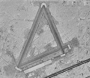
23 June 1996Type USAAF Training Airfield Coordinates 32°48′54.90″N 113°31′40.03″W / 32.81525°N 113.5277861°W Built 1943-1944 In use 1943-1945 (Active)
1945-1957 (Inactive)Controlled by United States Army Air Forces Garrison Fourth Air Force 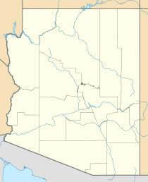
 Dateland AAFLocation of Dateland Army Airfield, AZ
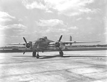 North American B-25J Mitchell medium bomber of the kind based at Dateland AAF
Dateland Army Airfield is an abandoned military airfield located 40 miles east of Yuma, Arizona.
Contents
Military use
The airfield was established on 1 January 1943 as a United States Army Air Forces training airfield, being under the command of the 3037th Army Air Force Base Unit, AAF Western Flying Training Command. Dateland was a sub-Post of Yuma AAFld. Colfred, Stovall and Welton Gunnery rangers were also established nearby. Dateland was originally designed for single engine aircraft gunnery training, but was converted to twin engine gunnery school in September 1943.
The site was chosen due to the availability of water and the adjacent location of the Yuma Gunnery Range. Construction was completed on 1 June 1943, and the facility was first garrisoned on 8 July 1943. Facilities constructed at the site between 1943-1946 were 95 buildings, 3 runways, 4 taxiways, a gasoline station, water system, electrical distribution system, sewage disposal system and perimeter fences.
In addition to the security and maintenance of the base, the airmen provided services for several flying organizations, among those being Mather Army Airfield which based 60 North American B-25J Mitchell aircraft from 25 December 1943 to 20 January 1944, logging a total of 11,000 hours of flight training.
The base was reduced to caretaker status on 31 October 1945, and was left with a contingent of 12 men and an officer to maintain the base. For many years the airfield was used for storage of various aircraft components. In the early 1950s, Dateland was used by various special forces squadrons of the MATS Air Resupply And Communications Service for training.
In 1957 the hangar and the other flight line buildings mysteriously burned down, and the Air Force sent in an investigation team to do an inventory on the B-25 parts and found none. The officer was court marshaled and the base was closed permanently in 1957.
Civil use
The airfield and all of its real estate was auctioned off in 1960 to private parties. In 1970 Dateland was subdivided into 3,300 lots leaving the airport intact. One owner was going to subdivide the airport area into lots and build small lakes. The airfield was apparently reopened as a private airfield at some point between 1971–77, however it was closed.
The present owners bought the Dateland property in 1995 and saved the airport from extinction. They planned to redevelop the airfield as a fly-in community, El Camino Del Sol Airpark, taking advantage of the extensive airfield facilities abandoned by the military. The developers touted Dateland as "the largest fly-in community in the USA", with a total of 427 lots having taxiway connections to the airfield, and a concrete ramp area big enough to park 300 planes. A motel and a museum were among the planned attributes.
Unfortunately, the commercial venture to reopen Dateland as a residential airpark had evidently failed. The remains of a sales trailer/office in the southwest corner of the airfield was boarded up and abandoned, which indicates this venture must not have been successful.
The remains of 3 runways still exist (6/24, 16/34, and the longest - 1/19, 6,600' long), along with a large concrete ramp area. The only building remaining is a sand-filled concrete bunker previously used to sight the machine guns of the B-25 Mitchell bombers.
See also
References
 This article incorporates public domain material from websites or documents of the Air Force Historical Research Agency.
- Shaw, Frederick J. (2004), Locating Air Force Base Sites History’s Legacy, Air Force History and Museums Program, United States Air Force, Washington DC, 2004.
- Manning, Thomas A. (2005), History of Air Education and Training Command, 1942–2002. Office of History and Research, Headquarters, AETC, Randolph AFB, Texas ASIN: B000NYX3PC
- Thole, Lou (1999), Forgotten Fields of America: World War II Bases and Training, Then and Now - Vol. 2. Publisher: Pictorial Histories Pub, ISBN 1575100517
External links
 Army Air Forces Training Command
Flying Training Flying Schools Eastern Flying Training Command · Central Flying Training Command · Western Flying Training CommandSpecialized Schools Bombardier · Contract Flying · Glider Training · Gunnery · Navigator
Technical Training Eastern Technical Training Command · Central Technical Training Command · Western Technical Training CommandCategories:- 1942 establishments
- USAAF West Coast Training Center
- World War II Desert Airfields
- USAAF Gunnery School
- Airfields of the United States Army Air Forces in Arizona
- History of Yuma County, Arizona
- Airports in Yuma County, Arizona


Wikimedia Foundation. 2010.