- D206 road (Croatia)
-
D206 state road
Route information Length: 28.7 km (17.8 mi) Major junctions From:  Hum na Sutli border crossing to Slovenia
 D207 in Hum na Sutli
 D507 near Valentinovo
To:  D1 in Krapina
Location Counties: Krapina-Zagorje Major cities: Krapina Highway system State roads in Croatia
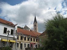 Krapina, at the eastern terminus of the D206 road
D206 is a state road in Hrvatsko Zagorje region of Croatia connecting Hum na Sutli border crossing to Slovenia to the city of Krapina and the A2 motorway Krapina interchange via D1 state road.[1] The road is 28.7 km (17.8 mi) long.[2]
The road, as well as all other state roads in Croatia, is managed and maintained by Hrvatske ceste, state owned company.[3]
Contents
Traffic volume
Traffic is regularly counted and reported by Hrvatske ceste, operator of the road.[4]
D206 traffic volume Road Counting site AADT ASDT Notes  D206
D2061112 Hum na Sutli 2,908 2,908 Adjacent to the Ž2092 junction. D2061105 Petrovsko 1,371 1,508 Adjacent to the Ž2121 junction. Road junctions and populated areas
D206 junctions/populated areas Type Slip roads/Notes 
Hum na Sutli border crossing to Slovenia.[5]
 Slovenian route 107 to Rogatec, Slovenia.
The western terminus of the road.
Hum na Sutli
D207 to Đurmanec (D1).Lastine
Ž2092 to Mali Tabor and Vučja Gorica.
Ž2095 to Klenovec Humski. Pregrada
Ž2096 to Donja Plemenšćina, Podbrezovica and Đurmanec (D207).
Ž2151 to Sopot and Desinić.Ž2118 to Gorjakovo. D507 to Gubaševo (D205).Valentinovo Slatina Svedruška
Ž2120 to Štuparje, Stara Ves Petrovska.Petrovsko Tkalci
Ž2121 to Gornja Pačetina.Krapina
D1 to Macelj border crossing[5] and Đurmanec (to the north) and to the A2 motorway Krapina interchange[1] and to Zabok (to the south).
Ž2098 to Đurmanec (D207) and to Popovec (D1).
The eastern terminus of the road.Sources
- ^ a b "Regulation on motorway markings, chainage, interchange/exit/rest area numbers and names" (in Croatian). Narodne novine. April 24, 2003. http://www.mmpi.hr/UserDocsImages/nn-73-03-Pravilnik-oznacav-ac.htm.
- ^ "Decision on categorization of public roads as state roads, county roads and local roads" (in Croatian). Narodne novine. February 17, 2010. http://narodne-novine.nn.hr/clanci/sluzbeni/2010_02_17_410.html.
- ^ "Public Roads Act" (in Croatian). Narodne novine. December 14, 2004. http://narodne-novine.nn.hr/clanci/sluzbeni/2004_12_180_3130.html.
- ^ "Traffic counting on the roadways of Croatia in 2009 - digest" (in English). Hrvatske ceste. May 1, 2010. http://www.hrvatske-ceste.hr/WEB%20-%20Legislativa/brojenje-prometa/CroDig2009.pdf.
- ^ a b "Map of border crossings and customs office areas" (in Croatian). Customs Administration of the Republic of Croatia. March 6, 2008. http://www.carina.hr/CURH/Dokumenti/Globalni/Karta_Carinarnica_RH.pdf.
See also
- State roads in Croatia
- Hrvatske ceste
Categories:- State roads in Croatia
- Krapina-Zagorje County


Wikimedia Foundation. 2010.