- D123 road (Croatia)
-
D123 state road
Route information Length: 1.1 km (0.7 mi) Major junctions From:  Sobra ferry port
To:  D120 in Sobra
Location Counties: Dubrovnik-Neretva Highway system State roads in Croatia
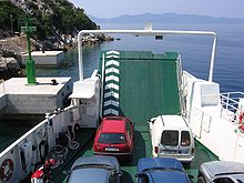 Jadrolinija ferry departing from Sobra, at the northern terminus of the D123 road
D123 is a state road on island of Mljet in Croatia connecting the main state road on the island (D120) to Sobra ferry port, from where Jadrolinija ferries fly to the mainland, docking in Prapratno and the D416 state road.[1] The road is 1.1 km (0.68 mi) long.[2]
The road, as well as all other state roads in Croatia, is managed and maintained by Hrvatske ceste, a state-owned company.[3]
Contents
Traffic volume
Traffic is not regularly counted on the road, however, Hrvatske ceste report number of vehicles using Prapratno-Sobra ferry line, connecting the D123 and D416 state road.[4] Substantial variations between annual (AADT) and summer (ASDT) traffic volumes are attributed to the fact that the road connects to a number of summer resorts.
D123 traffic volume Road Counting site AADT ASDT Notes  D123
D1238311 Prapratno-Sobra 96 237 Vehicles using Prapratno-Sobra ferry line. Road junctions and populated areas
D123 junctions/populated areas Type Slip roads/Notes 
Sobra ferry port – access to the mainland port of Prapratno (by Jadrolinija)[1] and the D416.
The northern terminus of the road.
Sobra
D120 to Pomena, Polače and Mljet National Park (to the west) and Saplunara (to the east).
The southern terminus of the road.Sources
- ^ a b "Jadrolinija ferry service" (in English). May 11, 2010. http://www.jadrolinija.hr/default.aspx?lang=2.
- ^ "Decision on categorization of public roads as state roads, county roads and local roads" (in Croatian). Narodne novine. February 17, 2010. http://narodne-novine.nn.hr/clanci/sluzbeni/2010_02_17_410.html.
- ^ "Public Roads Act" (in Croatian). Narodne novine. December 14, 2004. http://narodne-novine.nn.hr/clanci/sluzbeni/2004_12_180_3130.html.
- ^ "Traffic counting on the roadways of Croatia in 2009 - digest" (in English). Hrvatske ceste. May 1, 2010. http://www.hrvatske-ceste.hr/WEB%20-%20Legislativa/brojenje-prometa/CroDig2009.pdf.
See also
- State roads in Croatia
- Hrvatske ceste
- Jadrolinija
Categories:- State roads in Croatia
- Dubrovnik-Neretva County

Wikimedia Foundation. 2010.