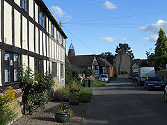
- Culmington
-
Coordinates: 52°26′02″N 2°44′56″W / 52.434°N 2.749°W
Culmington is a small village and civil parish in south Shropshire, England.
The nearest towns are Craven Arms and Ludlow. The village is situated just off the B4365 road, north of Stanton Lacy.
The River Corve flows just to its east. The village lies at around 100m above sea level.
External links
Ceremonial county of Shropshire Boroughs or districts Major settlements Bishop's Castle • Bridgnorth • Broseley • Church Stretton • Cleobury Mortimer • Clun • Craven Arms • Ellesmere • Ludlow • Market Drayton • Much Wenlock • Newport • Oswestry • Shifnal • Shrewsbury • Telford (Dawley • Madeley • Oakengates • Wellington) • Wem • Whitchurch
See also: List of civil parishes in ShropshireRivers Topics Categories:- Shropshire geography stubs
- Civil parishes in Shropshire
- Villages in Shropshire
Wikimedia Foundation. 2010.

