- Cozy Dell Shale
-
Cozy Dell Shale
Stratigraphic range: Eocene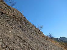
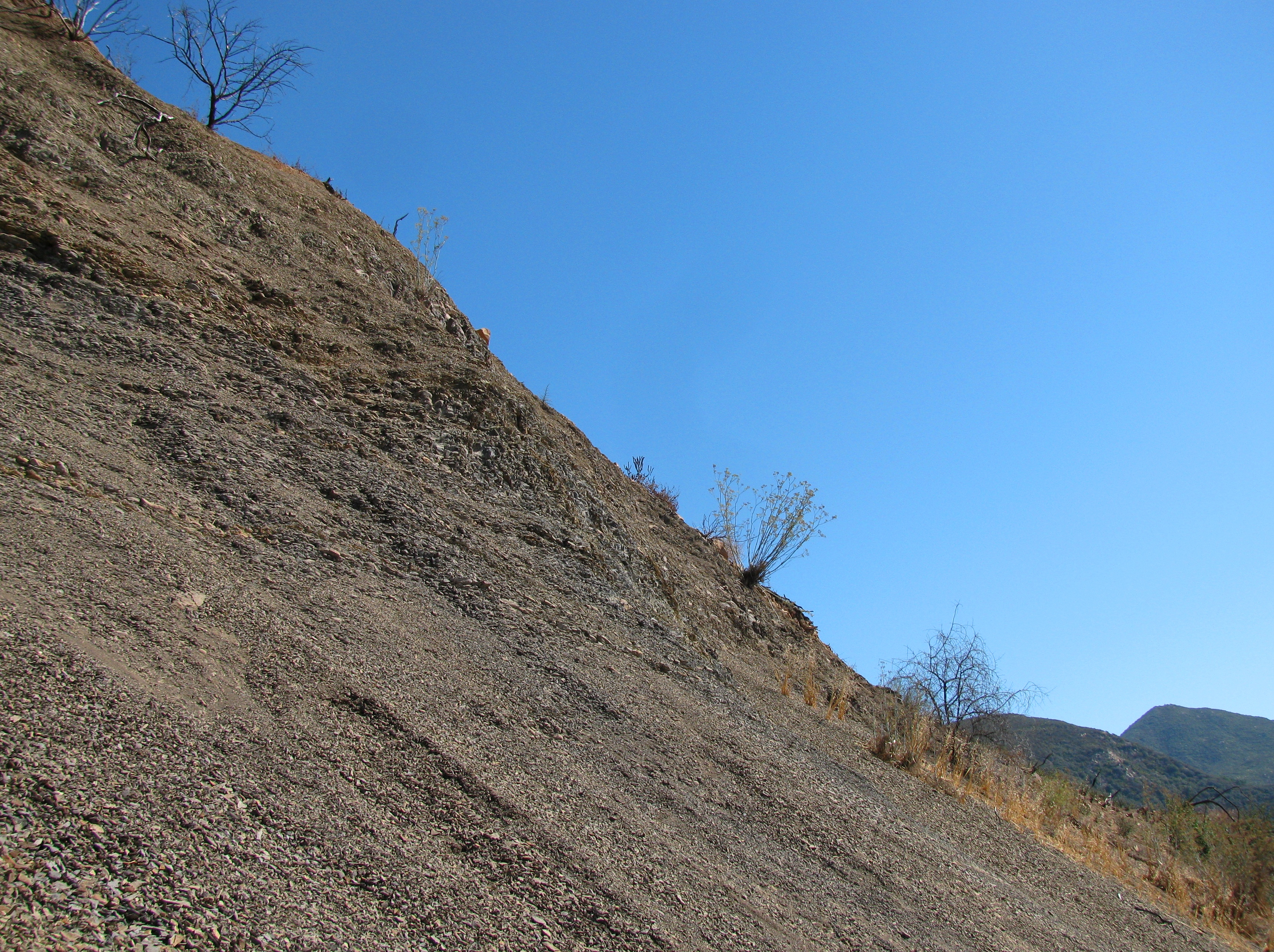
Weathered outcrop of the Cozy Dell Shale, with talus slope, in the Santa Ynez Mountains, California.Type sedimentary Underlies Coldwater Formation Overlies Matilija Sandstone Thickness 1,500 to 4,000 feet[1] Lithology Primary shale Other minor sandstone beds, calcareous nodules Location Named for Cozy Dell Canyon, Ventura County Named by Kerr and Schenck (1928)[2] Region Coastal southern California Country United States The Cozy Dell Shale is a sedimentary geologic unit of late Eocene age found principally in the Santa Ynez Mountain range north of Santa Barbara, California, from near Point Arguello in the west to central Ventura County in the east. A relatively soft and easily weathered unit, it forms saddles and passes between the more resistant Coldwater and Matilija formations, which form the prominent scenic peaks and ridges in the range. It outcrops infrequently, weathering instead to clayey soil which supports dense stands of chaparral.[3]
Contents
Type locality and extent
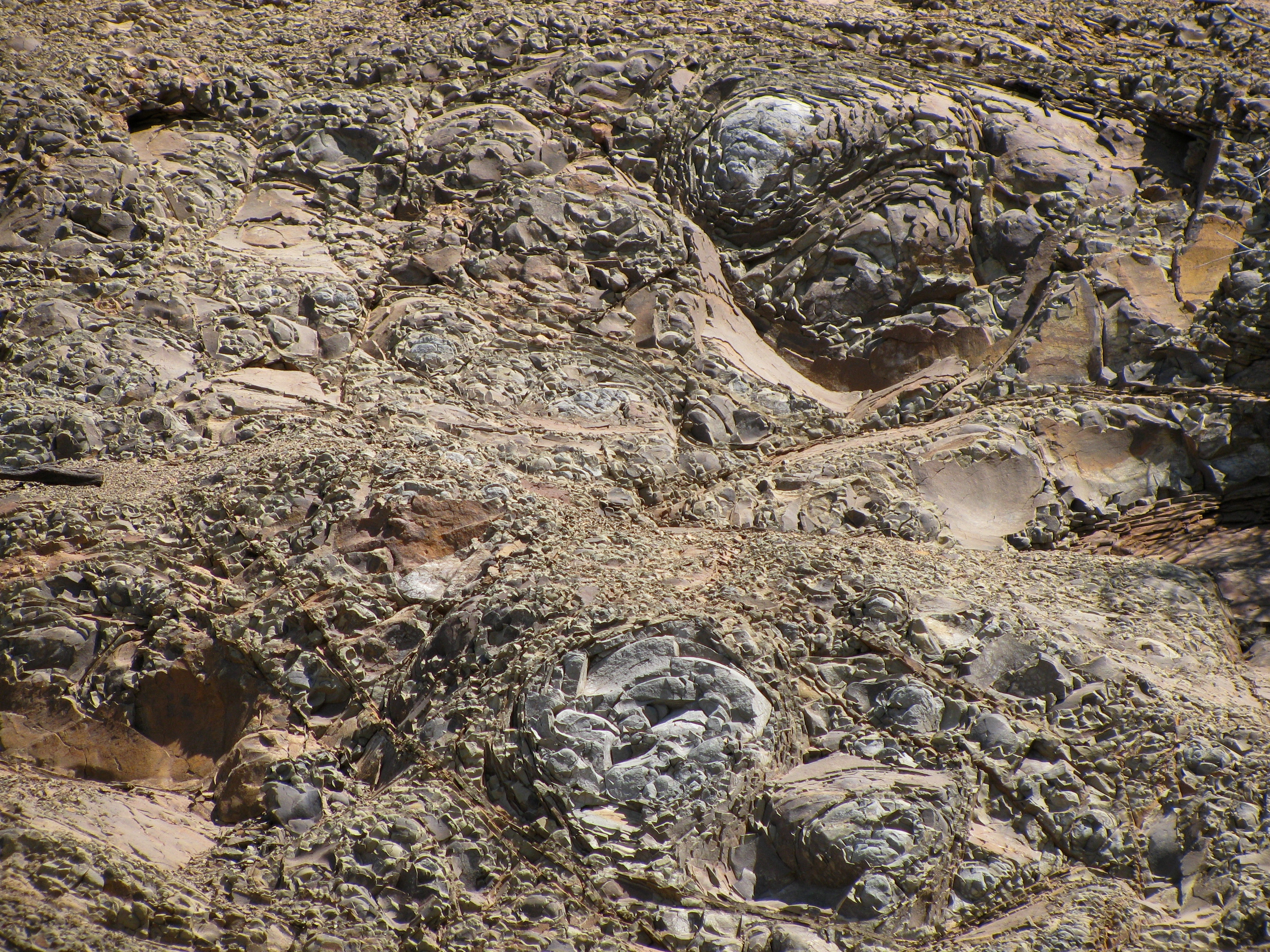
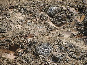 Close-up of the bedding of the Cozy Dell Shale. Scale is about 10 feet across.
The type locality of the Cozy Dell is in Cozy Dell Canyon, on the south slope of Nordhoff Ridge north of Ojai in Ventura County. The formation extends continuously from the mountains north of Ojai westward along the south slope of the Santa Ynez Mountains into Santa Barbara County, crossing the crest of the Santa Ynez range under and west of San Marcos Pass and then back again, forming much of the crest of the range north of Goleta. In the western portion of its range it grades into the Sacate Formation; north of the Santa Ynez crest it disappears underneath other units including the Coldwater Sandstone. South of the mountains, the unit dips under the coastal plain and then under the Santa Barbara Channel, where it is encountered in drill cores many thousands of feet below the sea floor. While the unit appears in a few small scattered locations north of the Santa Ynez River, there it has mostly been eroded away.[4]
Thickness of the formation varies widely. It is thickest west of San Marcos Pass, in the approximate center of its distribution, where it reaches 4,000 feet; within the Santa Ynez Mountains overall it averages about 1,700 feet thick.[5] In drill cores in the Santa Barbara Channel, it is considerably thinner, measuring 650 feet thick in the Hondo Oil Field[6] and only 350 feet in the Molino Gas Field, west of the Hondo field.[7] The formation dips to the south from the Santa Ynez Mountains, underneath the coastal plain, and then under the Santa Barbara Channel; in the Molino field the top of the formation is 13,000 feet below the sea floor.[7]
The unit was originally considered to be the middle part of the three-unit Tejon Formation, and appears that way in publications beginning in 1928. By the middle 1960s, it was considered to be a formation in its own right, along with the underlying Matilija and overlying Coldwater formations.[8]
Characteristics and deposition environment
The Cozy Dell Shale is gray to dark gray, weathering to brown and olive, and is mostly an argillaceous to silty shale unit. It also contains small beds of sandstones and a few areas of conglomerate, most significantly west of San Marcos Pass.[9][10] The unit breaks apart quickly when exposed to the elements, weathering to clayey soil supporting dense chaparral growth. Since it is sandwiched between two highly resistant rock units – the Matilija and Coldwater sandstones – and upended onto its side through most of its extent, it erodes to passes and saddles between the sandstone peaks and ridges of the adjacent units. Where it occurs in the subsurface, such as in the oil fields on the coast and offshore, it is usually highly impermeable – typical of shaly units – and serves as a cap rock, trapping hydrocarbons below.[6] In some cases, such as in the now-abandoned Cuarta Offshore Oil Field, about six miles west-southwest of Gaviota, the individual sandstone beds within the unit are sufficiently permeable to contain oil or gas, which in the case of the Cuarta field are 7,000 feet below the ocean floor.[11]
As a potential hydrocarbon resource, the unit is grouped with above- and below-lying sandstone units as part of the Gaviota-Sacate-Matilija Sandstone Play. While the Cozy Dell itself does not likely contain large pools of oil or gas, it may be a source rock for petroleum found in other units.[12]
The Cozy Dell represents the era when the Eocene sea covering the region reached its maximum depth. Only the finest-grained sediments reached the ocean bottom, and the land providing the outflow had been eroded to low relief. The sediments were principally a micaceous mud, although a fairly high organic content indicates microorganisms flourished on the ocean bottom at that time.[13] Recent magnetostratigraphic dating has determined that the Cozy Dell unit was deposited between approximately 46 to 42 Ma (million years ago).[14] Additionally, studies of the correlation of the unit with similar units in the California Central Valley, along with paleomagnetic data, show that the tectonic block on which the Cozy Dell and subsequent formations was deposited – including the western part of the Transverse Ranges – has rotated clockwise almost 90 degrees since the time of deposition.[14][15]
Paleontology
While the formation is rich in microfossils, no significant larger fossils have been found in southwestern Santa Barbara County.[16] However some larger fossils have been found, particularly in the region near Ojai.[13]
Notes
- ^ Dibblee, Thomas. Geology of the central Santa Ynez Mountains, Santa Barbara County, California. Bulletin 186, California Division of Mines and Geology. San Francisco, 1966. 29
- ^ Dibblee (1966), 28
- ^ Dibblee (1966) 29-30
- ^ Dibblee (1966) 28-29
- ^ Dibblee (1966) 29
- ^ a b Nancy W. Hinman, Daniel E. Schwartz. "Lithologic and Diagenetic Sequences of the Monterey Formation, Molino Field, Offshore Santa Barbara, California." SEPM Core Workshop No. 14. San Francisco, June 3, 1990. ISBN 0-918985-84-6 p. 274
- ^ a b Gregory A. Miles and Catherine A. Rigsby. "Lithostratigraphy and Depositional Environments of the Vaqueros and Upper Sespe/Alegria Formations, Hondo Field, Santa Barbara Channel, California." SEPM Core Workshop No. 14. San Francisco, June 3, 1990. ISBN 0-918985-84-6 p. 43
- ^ Dibblee, 28
- ^ Thomas M. Dibblee, 1987. Geologic Map of the Lake Cachuma Quadrangle, Santa Barbara County, California. California Department of Conservation, Division of Mines and Geology. Dibblee Foundation Map DF#10.
- ^ Dibblee (1966), 29
- ^ California Department of Conservation, Division of Oil, Gas, and Geothermal Resources (DOGGR). California Oil and Gas Fields, Volumes I, II and III. Vol. I (1998), Vol. II (1992), Vol. III (1982). PDF file available on CD from www.consrv.ca.gov. p. 652-653
- ^ James M. Galloway. "Santa Barbara-Ventura Basin Province." 112-114.
- ^ a b Dibblee (1966), 30
- ^ a b Donald R. Prothero and Justin R. Britt. "Magnetic stratigraphy and tectonic rotation of the Middle Eocene Matilija Sandstone and Cozy Dell Shale, Ventura County, California: implications for sequence stratigraphic correlations." Earth and Planetary Science Letters, Volume 163, Issues 1-4, November 1998, Pages 261-273. doi:10.1016/j.physletb.2003.10.071
- ^ Deborah R. Harden. California Geology. Prentice Hall, 1997. ISBN 0-02-350042-5 p. 433
- ^ County of Santa Barbara. Paleontological Resources section from the Lompoc Wind Project Final Environmental Impact Report. 3.12-4
Categories:- Geologic formations of the United States
- Natural history of California
- Geology of California
Wikimedia Foundation. 2010.