- Courtland Airport
-
Courtland Airport
Lawrence County Airport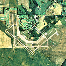
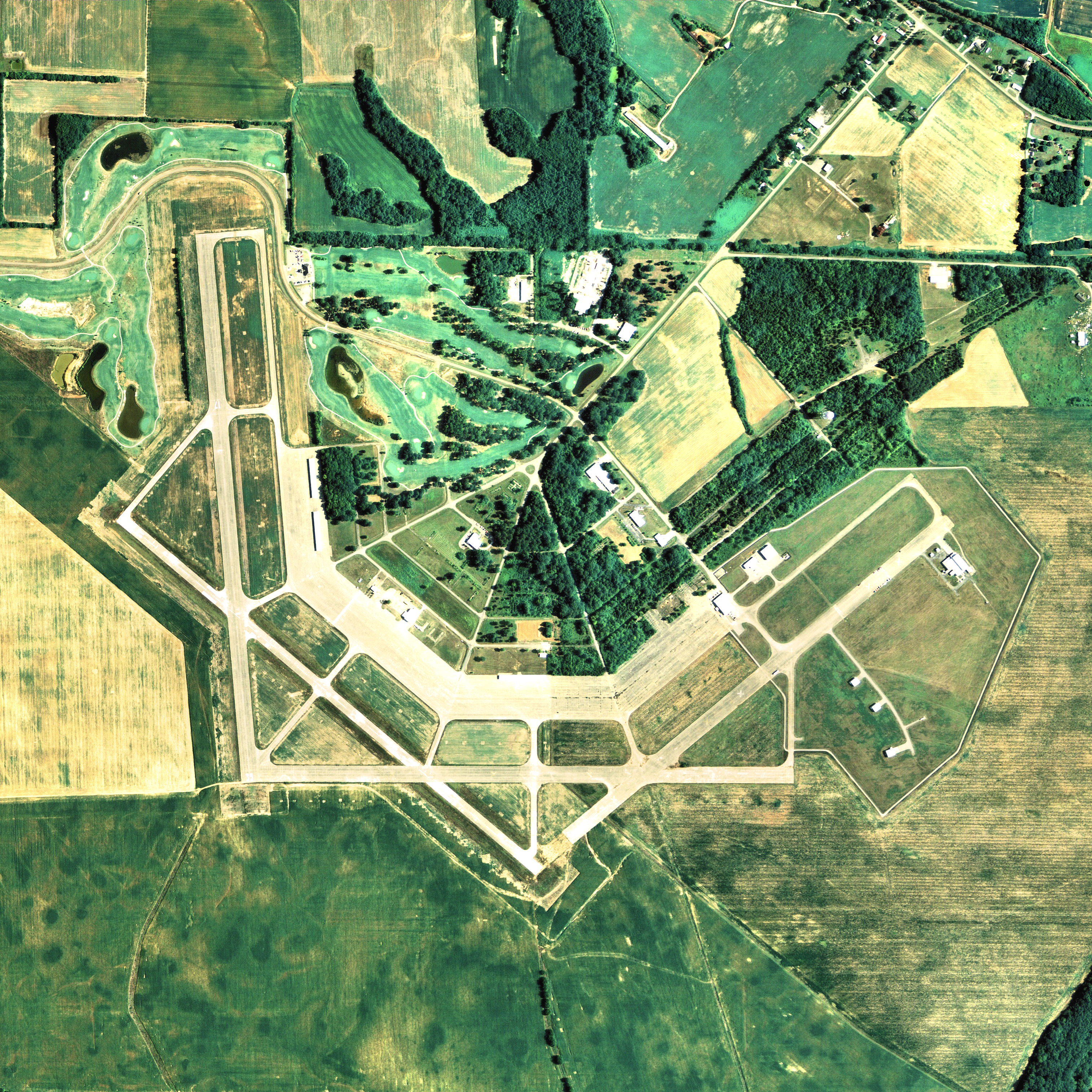
NAIP aerial image, 29 June 2006 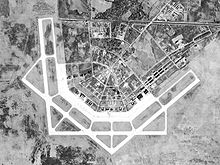
Courtland Army Airfield, 28 December 1949 IATA: none – ICAO: none – FAA LID: 9A4 Summary Airport type Public Owner Lawrence County Commission Serves Courtland, Alabama Elevation AMSL 588 ft / 179 m Coordinates 34°39′34″N 087°20′56″W / 34.65944°N 87.34889°WCoordinates: 34°39′34″N 087°20′56″W / 34.65944°N 87.34889°W Map Location of airport in Alabama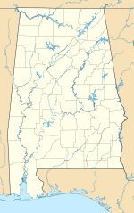
 9A4
9A4Runways Direction Length Surface ft m 13/31 4,994 1,522 Concrete 17/35 4,994 1,522 Concrete Statistics (2010) Aircraft operations 11,900 Based aircraft 32 Source: Federal Aviation Administration[1] Courtland Airport[1][2] (FAA LID: 9A4) is a public-use airport located two nautical miles (4 km) northeast of the central business district of Courtland, a town in Lawrence County, Alabama, United States. It is owned by the Lawrence County Commission[1] and was formerly known as Lawrence County Airport.[3][4]
This airport is included in the FAA's National Plan of Integrated Airport Systems for 2011–2015[5] and 2009–2013,[6] both of which categorized it as a general aviation facility.
Contents
History
Following the onset of World War II the United States faced a challenging goal to train upwards of 75,000 to 100,000 pilots per year. It was recognized that to achieve this goal, many new training fields would have to be constructed - hundreds across the country. Due to the climate allowing year-round flight instruction, as well as the low airways congestion, North Alabama was considered to be a good location for one of the new Army Air Force training fields. Following a review by a site selection board, Courtland was chosen to receive this facility. It was considered the best overall site of three evaluated within the North Alabama region.
Selection took place and the land acquired in April 1942. Construction was rapid given the emergency wartime conditions and within three months the post was to be in full operation. The airfield consisted of four concrete runways 5000x150(N/S), 5000x150(NE/SW), 5000x150(E/W), 5000x150(NW/SE). Also many taxiways, landing aids, and an extended length parking apron. Auxiliary airfields to support the training activities at the base were:
- Danville (Auxiliary #1) 34°25′27″N 087°07′08″W / 34.42417°N 87.11889°W
- Trinity (Auxiliary #2) 34°18′15″N 087°09′22″W / 34.30417°N 87.15611°W
- Bay (Auxiliary #3) 34°42′49″N 087°15′45″W / 34.71361°N 87.2625°W
- Leighton (Auxiliary #4) 34°39′27″N 087°29′40″W / 34.6575°N 87.49444°W
- Muscle Shoals (Auxiliary #5) 34°44′50″N 087°36′50″W / 34.74722°N 87.61389°W
In addition to the airfield, the building of a large support base with several hundred buildings, numerous streets, a utility network, was carried out with barracks, various administrative buildings, maintenance shops and hangars. The station facility consisted of a large number of buildings based on standardized plans and architectural drawings, with the buildings designed to be the "cheapest, temporary character with structural stability only sufficient to meet the needs of the service which the structure is intended to fulfill during the period of its contemplated war use" was underway. To conserve critical materials, most facilities were constructed of wood, concrete, brick, gypsum board and concrete asbestos. Metal was sparsely used. The station was designed to be nearly self-sufficient, with not only hangars, but barracks, warehouses, hospitals, dental clinics, dining halls, and maintenance shops were needed. There were libraries, social clubs for officers, and enlisted men, and stores to buy living necessities. The buildings, together with complete water, sewer, electric and gas utilities built within a short span of approximately 8 months, with the air field officially being activated in December 1942 as Courtland Army Air Field (CAAF) . Courtland was assiged to the Southeast Training Center of the Army Air Force Training Command. It was commanded by the 446th Army Air Force Base Unit.
Courtland AAF was the home of a Basic Flying School which utilized Vultee BT-13s for the Air Cadets. Personnel were required to fire pistols or carbines for marksmanship training and practice gas attack drills. The chemical agents used during training were tear gas, mustard agent, chlorine gas, incendiary and smoke munitions.
As part of a personal biography of his years in the Service, Dr. Charles Dills has written a first-person account of some of his experiences and impressions while at Courtland Army Airfield. Dr. Dills was a member of the first cadet class at Courtland (Class 43-E). This first cadet class began instruction there approximately late January, 1943.[7]
The Basic Flight School was replaced by a Specialized 4-Engine Flight School in August 1944. Establishment of this school involved the transfer of B-24 "Liberator" bombers and personnel from Chanute Field, Illinois. During this time, in addtion to the 4-Engine Flight School, a transition squadron was also emplaced at Courtland. The role of the transition squadron largely involved the retraining and/or reclassification of returning crews from Europe (crews who had fulfilled their required missions). Many personnel went on to B-29 schools at other locations as they were reclassified.
As training needs decreased toward the end of the war, training air fields were deactivated across the country. Courtland AAF was one of these, it being deactivated in June 1945. At the end of the war the airfield was determined to be excess by the War Department in 1946 and was excessed. The site was returned to the State of Alabama by Quitclaim Deed in 1948.
With regard to the original structures, most everything but the runways, and several concrete slabs with 3 or 4 wide concrete steps are gone now. A steel-framed aircraft hangar that was once used at Courtland still exists and is still in use, but is no longer located at the Courtland site. This structure was disassembled and moved to the Birmingham Municipal Airport (now Birmingham International Airport) during the early 1950's.
Lockheed Martin and other light industries call the Lawrence County Industrial Airpark site home today. A golf course also hugs the northeast to west perimeter.
Facilities and aircraft
Courtland Airport covers an area of 350 acres (142 ha) at an elevation of 588 feet (179 m) above mean sea level. It has two runways, 13/31 and 17/35, each with a concrete surface measuring 4,994 by 150 feet (1,522 x 46 m).[1]
For the 12-month period ending April 14, 2010, the airport had 11,900 aircraft operations, an average of 32 per day: 92% general aviation and 8% military. At that time there were 32 aircraft based at this airport: 81% single-engine and 19% multi-engine.[1]
See also
References
- ^ a b c d e FAA Airport Master Record for 9A4 (Form 5010 PDF). Federal Aviation Administration. Effective 25 August 2011.
- ^ "Air Show set for next week in Courtland". The Moulton Advertiser. 15 September 2011. http://www.moultonadvertiser.com/articles/2011/09/15/news/doc4e7203582de6b890740209.txt.
- ^ "Businessman seeks to lead airport". The Decatur Daily. 11 January 2007. http://legacy.decaturdaily.com/decaturdaily/news/070111/airport.shtml.
- ^ "Airport Information Reference Page (9A4)". FlyingDatabase.com. 16 August 2010. http://www.flyingdatabase.com/Air/store/FileDetail.php?FileID=2308.
- ^ "2011–2015 NPIAS Report, Appendix A (PDF, 2.03 MB)". 2011–2015 National Plan of Integrated Airport Systems. Federal Aviation Administration. 4 October 2010. http://www.faa.gov/airports/planning_capacity/npias/reports/media/2011/npias_2011_appA.pdf.
- ^ "2009–2013 NPIAS Report, Appendix A: Part 1 (PDF, 1.33 MB)". 2009–2013 National Plan of Integrated Airport Systems. Federal Aviation Administration. 15 October 2008. http://www.faa.gov/airports/planning_capacity/npias/reports/media/2009/npias_2009_appA_part1.pdf.
- ^ http://www.charlies-web.com/WWII_med/contentsced15.html
- ^
 This article incorporates public domain material from websites or documents of the Air Force Historical Research Agency.
 - ^ Thole, Lou (1999), Forgotten Fields of America : World War II Bases and Training, Then and Now - Vol. 2. Publisher: Pictorial Histories Pub, ISBN 1575100517
- ^ Shaw, Frederick J. (2004), Locating Air Force Base Sites History’s Legacy, Air Force History and Museums Program, United States Air Force, Washington DC, 2004.
- ^ Manning, Thomas A. (2005), History of Air Education and Training Command, 1942–2002. Office of History and Research, Headquarters, AETC, Randolph AFB, Texas ASIN: B000NYX3PC
External links
- Tennessee Valley Air Center, the fixed base operator (FBO)
- Aerial image as of 16 January 1999 from USGS The National Map
- FAA Terminal Procedures for 9A4, effective 20 October 2011
- Resources for this airport:
- AirNav airport information for 9A4
- FlightAware airport information and live flight tracker
- SkyVector aeronautical chart for 9A4
 Army Air Forces Training Command
Flying Training Flying Schools Eastern Flying Training Command · Central Flying Training Command · Western Flying Training CommandSpecialized Schools Bombardier · Contract Flying · Glider Training · Gunnery · Navigator
Technical Training Eastern Technical Training Command · Central Technical Training Command · Western Technical Training CommandCategories:- 1942 establishments
- Airports in Alabama
- Airfields of the United States Army Air Forces in Alabama
- Buildings and structures in Lawrence County, Alabama
- USAAF Southeast Training Center
- Transportation in Lawrence County, Alabama


Wikimedia Foundation. 2010.